When you click on links to various merchants on this site and make a purchase, this can result in this site earning a commission. Affiliate programs and affiliations include, but are not limited to, the eBay Partner Network.
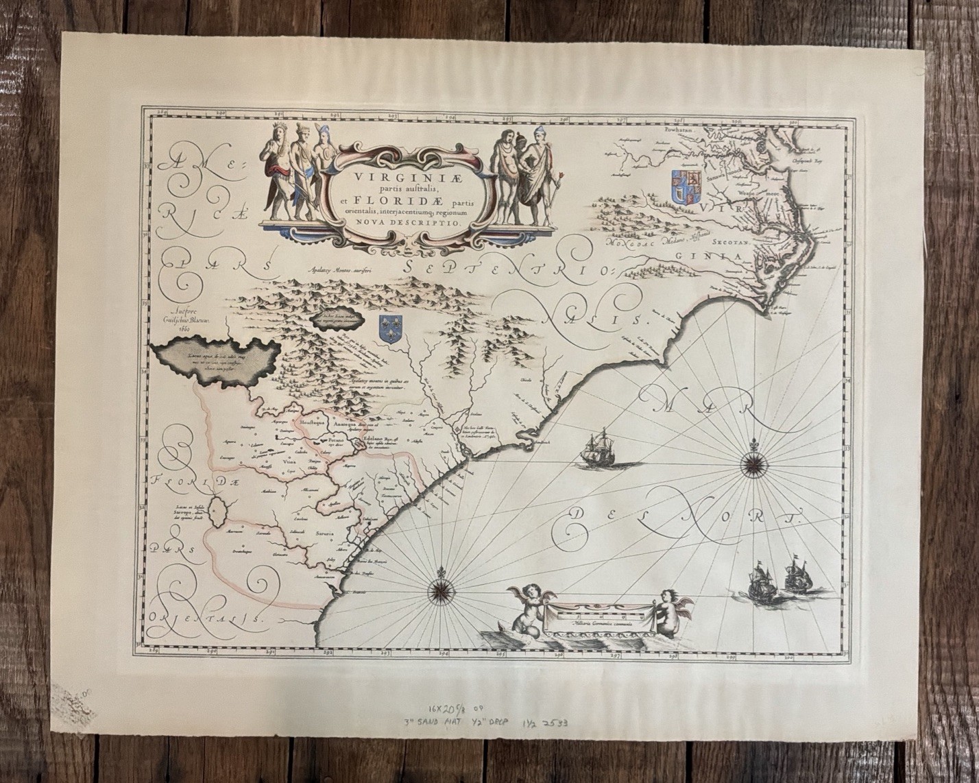
VIRGINIA FLORIDA 1640 WILLEM BLAEU LARGE ANTIQUE MAP LATIN EDITION 17TH CENTURY
Print size 24” x 19”
Map size is 19 3/4” x 15”
I not a map person, but is vintage and maybe antique.
Paper has grid marks all the way through.
Map was press, with beveled edges around the map.
Edges of whole print and not sharply cut.
Has no visible crease???
Title of the map :
"VIRGINIAE partis australis, et FLORIDAE partis orientalis, interjacentiumqus regionum NOVA DESCRIPTIO"
Large and nice antique copper engraved map of the southeast part of North America, by Willem Janszoon BLAEU (1571-1638), 17th century.
The map extends from the southern part of Chesapeake Bay to northern Florida. Cartographically it improves on the Hondius map of 1606, on which it was derived, with the Chesapeake Bay correctly indicated as a large bay and the Carolinas and Georgian coasts depicted more accurately. The map presents the English and French colonial interests in the region as depicted by their respective royal arms. At the southern end of the Appalachians is a note concerning gold and silver mines.
The map is decorated with a large cartouche flanked by Native Americans. The Atlantic Ocean contains two compass roses, three sailing ships and two aquatic putti holding the scale of miles. Dutch text on verso.
Blaeu family was the most important cartographer and geographer in 17th century.
Willem Janszoon Blaeu was the founder of the Blaeu cartography dynasty, the finest mapmakers of the Golden age of Dutch cartography.
He studied astronomy with Tycho Brahe at Uranienborg, and moved to Amsterdam to establish a shop in 1605, close his contemporaries and rivals Johannes Janssonius and Jacob Colom. He produced globes at first. Then, the sons of Willem, Johan and Cornelius, joined him in the firm. They produced their first atlas together in 1630 the "Atlas Appendix". Five years later, their produced their "Atlas Novus", edited in 4 languages. After the death of Willem, Joan expanded the Atlas Novus into the Atlas Major, the largest atlas of its time. This edition had between nine and twelve volumes, beautifully engraved and coloured. In 1648, they produced a very large wall world map in 20 parts. And they continued to produce globes too.