When you click on links to various merchants on this site and make a purchase, this can result in this site earning a commission. Affiliate programs and affiliations include, but are not limited to, the eBay Partner Network.
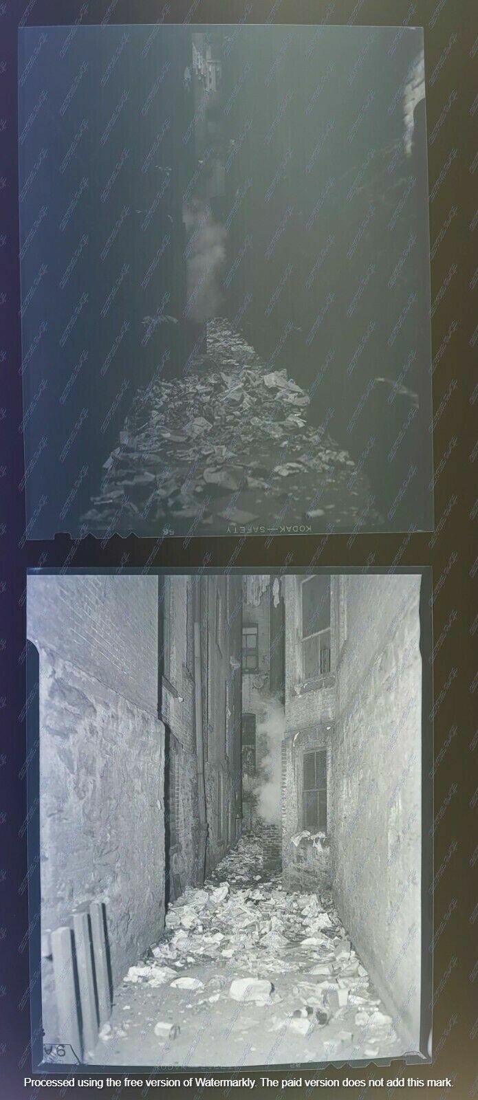
4 VINTAGE ORIGINAL 4X5 INCH NEGATIVES WITH ORIGINAL ENVELOPE AND PAPER DESCRIPTION FROM 1947 OF THE GONZOLEZ FAMILY SHOWING GARBAGE RIDDEN AREAWAYS IN REAR ANBD SIDE OF BUILDING 54V LENOX AVE, NYC IN HARLEM
Harlem is a neighborhood in Upper Manhattan, New York City. It is bounded roughly by Frederick Douglass Boulevard, St. Nicholas Avenue, and Morningside Park on the west; the Harlem River and 155th Street on the north; Fifth Avenue on the east; and Central Park North on the south. The greater Harlem area encompasses several other neighborhoods and extends west to the Hudson River, north to 155th Street, east to the East River, and south to Martin Luther King Jr. Boulevard, Central Park, and East 96th Street.
Originally a Dutch village, formally organized in 1658,[4] it is named after the city of Haarlem in the Netherlands. Harlem\'s history has been defined by a series of economic boom-and-bust cycles, with significant population shifts accompanying each cycle.[5] Harlem was predominantly occupied by Jewish and Italian Americans in the 19th century, but African-American residents began to arrive in large numbers during the Great Migration in the 20th century. In the 1920s and 1930s, Central and West Harlem were the center of the Harlem Renaissance, a major African-American cultural movement. With job losses during the Great Depression of the 1930s and the deindustrialization of New York City after World War II, rates of crime and poverty increased significantly.[6] In the 21st century, crime rates decreased significantly, and Harlem started to gentrify.
The area is served by the New York City Subway and local bus routes. It contains several public elementary, middle, and high schools, and is close to several colleges including Columbia University and the City College of New York. Central Harlem is part of Manhattan Community District 10.[1] It is patrolled by the 28th and 32nd Precincts of the New York City Police Department. The greater Harlem area also includes Manhattan Community Districts 9 and 11 and several police precincts, while fire services are provided by four New York City Fire Department companies.Contents1 Geography1.1 SoHa controversy1.2 Political representation2 History3 Culture3.1 Music3.2 Religious life3.3 Landmarks3.3.1 Officially designated landmarks3.3.2 Other points of interest4 Demographics4.1 Central Harlem4.2 Other sections5 Police and crime5.1 Crime trends5.2 Gangs6 Fire safety7 Health7.1 Social factors7.2 Health problems7.2.1 Health and housing conditions7.2.2 Asthma7.2.3 Other health problems8 Post offices and ZIP Codes9 Education9.1 Schools9.2 Higher education9.3 Libraries10 Transportation10.1 Bridges10.2 Public transportation10.2.1 Subway10.2.2 Bus11 See also12 References13 Further reading14 External linksGeography
A map of Upper Manhattan, with Greater Harlem highlighted. Harlem proper is the neighborhood in the center.Harlem is located in Upper Manhattan, often referred to as \"Uptown\" by locals. The three neighborhoods comprising the greater Harlem area—West, Central, and East Harlem—stretch from the Harlem River and East River to the east, to the Hudson River to the west; and between 155th Street in the north, where it meets Washington Heights, and an uneven boundary along the south that runs along 96th Street east of Fifth Avenue, 110th Street between Fifth Avenue to Morningside Park, and 125th Street west of Morningside Park to the Hudson River.[7][8][9] Encyclopædia Britannica references these boundaries,[10] though the Encyclopedia of New York City takes a much more conservative view of Harlem\'s boundaries, regarding only central Harlem as part of Harlem proper.[11]: 573
Central Harlem is the name of Harlem proper; it falls under Manhattan Community District 10.[7] This section is bounded by Fifth Avenue on the east; Central Park on the south; Morningside Park, St. Nicholas Avenue and Edgecombe Avenue on the west; and the Harlem River on the north.[7] A chain of three large linear parks—Morningside Park, St. Nicholas Park and Jackie Robinson Park—situated on steeply rising banks, form most of the district\'s western boundary. Fifth Avenue, as well as Marcus Garvey Park (also known as Mount Morris Park), separate this area from East Harlem to the east.[7] Central Harlem includes the Mount Morris Park Historic District.
West Harlem (Manhattanville and Hamilton Heights) comprises Manhattan Community District 9 and does not form part of Harlem proper. The two neighborhoods\' area is bounded by Cathedral Parkway/110th Street on the south; 155th Street on the north; Manhattan/Morningside Ave/St. Nicholas/Bradhurst/Edgecombe Avenues on the east; and Riverside Park/the Hudson River on the west. Manhattanville begins at roughly 123rd Street and extends northward to 135th Street. The northernmost section of West Harlem is Hamilton Heights.[8]
East Harlem, also called Spanish Harlem or El Barrio, is located within Manhattan Community District 11, which is bounded by East 96th Street on the south, East 138th Street on the north, Fifth Avenue on the west, and the Harlem River on the east. It is not part of Harlem proper.[9]
SoHa controversyFurther information: Morningside Heights, Manhattan § SoHa controversyIn the 2010s some real estate professionals started rebranding south Harlem and Morningside Heights as \"SoHa\" (a name standing for \"South Harlem\" in the style of SoHo or NoHo) in an attempt to accelerate gentrification of the neighborhoods. \"SoHa\", applied to the area between West 110th and 125th Streets, has become a controversial name.[12][13][14] Residents and other critics seeking to prevent this renaming of the area have labelled the SoHa brand as \"insulting and another sign of gentrification run amok\"[15] and have said that \"the rebranding not only places their neighborhood\'s rich history under erasure but also appears to be intent on attracting new tenants, including students from nearby Columbia University\".[16]
Multiple New York City politicians have initiated legislative efforts to curtail this practice of neighborhood rebranding, which when successfully introduced in other New York City neighborhoods, have led to increases in rents and real estate values, as well as \"shifting demographics\".[16] In 2011, U.S. Representative Hakeem Jeffries attempted but failed to implement legislation \"that would punish real estate agents for inventing false neighborhoods and redrawing neighborhood boundaries without city approval.\"[16] By 2017, New York State Senator Brian Benjamin also worked to render illegal the practice of rebranding historically recognized neighborhoods.[16]
Political representationPolitically, central Harlem is in New York\'s 13th congressional district.[17][18] It is in the New York State Senate\'s 30th district,[19][20] the New York State Assembly\'s 68th and 70th districts,[21][22] and the New York City Council\'s 7th, 8th, and 9th districts.[23]
History
Harlem, from the old fort in the Central Park, New York Public Library
Three Harlem Women, ca. 1930Main article: History of HarlemBefore the arrival of European settlers, the area that would become Harlem (originally Haarlem) was inhabited by a Native American band, the Wecquaesgeek, dubbed Manhattans or Manhattoe by Dutch settlers, who along with other Native Americans, most likely Lenape,[24] occupied the area on a semi-nomadic basis. As many as several hundred farmed the Harlem flatlands.[25] Between 1637 and 1639, a few settlements were established.[26][27] The settlement of Harlem was formally incorporated in 1660[28] under the leadership of Peter Stuyvesant.[29]
During the American Revolution, the British burned Harlem to the ground.[30] It took a long time to rebuild, as Harlem grew more slowly than the rest of Manhattan during the late 18th century.[31] After the American Civil War, Harlem experienced an economic boom starting in 1868. The neighborhood continued to serve as a refuge for New Yorkers, but increasingly those coming north were poor and Jewish or Italian.[32] The New York and Harlem Railroad,[33] as well as the Interborough Rapid Transit and elevated railway lines,[34] helped Harlem\'s economic growth, as they connected Harlem to lower and midtown Manhattan.Apartment building in Central Harlem
A condemned building in Harlem after the 1970sThe Jewish and Italian demographic decreased, while the black and Puerto Rican population increased in this time.[35] The early-20th century Great Migration of black people to northern industrial cities was fueled by their desire to leave behind the Jim Crow South, seek better jobs and education for their children, and escape a culture of lynching violence; during World War I, expanding industries recruited black laborers to fill new jobs, thinly staffed after the draft began to take young men.[36] In 1910, Central Harlem population was about 10% black people. By 1930, it had reached 70%.[37]
Starting around the time of the end of World War I, Harlem became associated with the New Negro movement, and then the artistic outpouring known as the Harlem Renaissance, which extended to poetry, novels, theater, and the visual arts. So many black people came that it \"threaten[ed] the very existence of some of the leading industries of Georgia, Florida, Tennessee and Alabama.\"[38] Many settled in Harlem. By 1920, central Harlem was 32.43% black. The 1930 census revealed that 70.18% of central Harlem\'s residents were black and lived as far south as Central Park, at 110th Street.[39]
However, by the 1930s, the neighborhood was hit hard by job losses in the Great Depression. In the early 1930s, 25% of Harlemites were out of work, and employment prospects for Harlemites stayed bad for decades. Employment among black New Yorkers fell as some traditionally black businesses, including domestic service and some types of manual labor, were taken over by other ethnic groups. Major industries left New York City altogether, especially after 1950. Several riots happened in this period, including in 1935 and 1943.
There were major changes following World War II. In the late 1950s and early 1960s, Harlem was the scene of a series of rent strikes by neighborhood tenants, led by local activist Jesse Gray, together with the Congress of Racial Equality, Harlem Youth Opportunities Unlimited (HARYOU), and other groups. These groups wanted the city to force landlords to improve the quality of housing by bringing them up to code, to take action against rats and roaches, to provide heat during the winter, and to keep prices in line with existing rent control regulations.[40]
The largest public works projects in Harlem in these years were public housing, with the largest concentration built in East Harlem.[41] Typically, existing structures were torn down and replaced with city-designed and managed properties that would, in theory, present a safer and more pleasant environment than those available from private landlords. Ultimately, community objections halted the construction of new projects.[42]
From the mid-20th century, the low quality of education in Harlem has been a source of distress. In the 1960s, about 75% of Harlem students tested under grade levels in reading skills, and 80% tested under grade level in math.[43] In 1964, residents of Harlem staged two school boycotts to call attention to the problem. In central Harlem, 92% of students stayed home.[44] In the post-World War II era, Harlem ceased to be home to a majority of the city\'s black people,[45] but it remained the cultural and political capital of black New York, and possibly black America.[46][47]
By the 1970s, many of those Harlemites who were able to escape from poverty left the neighborhood in search of better schools and homes, and safer streets. Those who remained were the poorest and least skilled, with the fewest opportunities for success. Though the federal government\'s Model Cities Program spent $100 million on job training, health care, education, public safety, sanitation, housing, and other projects over a ten-year period, Harlem showed no improvement.[48] The city began saleing its enormous portfolio of Harlem properties to the public in 1985. This was intended to improve the community by placing property in the hands of people who would live in them and maintain them. In many cases, the city would even pay to completely renovate a property before selling it (by lottery) below market value.[49]
After the 1990s, Harlem began to grow again. Between 1990 and 2006 the neighborhood\'s population grew by 16.9%, with the percentage of black people decreasing from 87.6% to 69.3%,[39] then dropping to 54.4% by 2010,[50] and the percentage of whites increasing from 1.5% to 6.6% by 2006,[39] and to \"almost 10%\" by 2010.[50] A renovation of 125th Street and new properties along the thoroughfare[51][52] also helped to revitalize Harlem.[53]
CultureSee also: Harlem Renaissance
Welcome to Harlem sign above the now defunct Victoria 5 cinema theater on 125th stIn the 1920s and 1930s, Central and West Harlem was the focus of the \"Harlem Renaissance\", an outpouring of artistic work without precedent in the American Black community. Though Harlem musicians and writers are particularly well remembered, the community has also hosted numerous actors and theater companies, including the New Heritage Repertory Theater,[29] National Black Theater, Lafayette Players, Harlem Suitcase Theater, The Negro Playwrights, American Negro Theater, and the Rose McClendon Players.[54]The Apollo Theater on 125th Street in November 2006The Apollo Theater opened on 125th Street on January 26, 1934, in a former burlesque house. The Savoy Ballroom, on Lenox Avenue, was a renowned venue for swing dancing, and was immortalized in a popular song of the era, \"Stompin\' At The Savoy\". In the 1920s and 1930s, between Lenox and Seventh Avenues in central Harlem, over 125 entertainment venues were in operation, including speakeasies, cellars, lounges, cafes, taverns, supper clubs, rib joints, theaters, dance halls, and bars and grills.[55]
133rd Street, known as \"Swing Street\", became known for its cabarets, speakeasies and jazz scene during the Prohibition era, and was dubbed \"Jungle Alley\" because of \"inter-racial mingling\" on the street.[56][57] Some jazz venues, including the Cotton Club, where Duke Ellington played, and Connie\'s Inn, were restricted to whites only. Others were integrated, including the Renaissance Ballroom and the Savoy Ballroom.
In 1936, Orson Welles produced his black Macbeth at the Lafayette Theater in Harlem.[58] Grand theaters from the late 19th and early 20th centuries were torn down or converted to churches. Harlem lacked any permanent performance space until the creation of the Gatehouse Theater in an old Croton aqueduct building on 135th Street in 2006.[59]Spiritual African Drummer on 135th Street between Adam Clayton Powell Boulevard and Frederick Douglass BoulevardFrom 1965 until 2007, the community was home to the Harlem Boys Choir, a touring choir and education program for young boys, most of whom are black.[60] The Girls Choir of Harlem was founded in 1989, and closed with the Boys Choir.[61]
Harlem is also home to the largest African American Day Parade, which celebrates the culture of African diaspora in America. The parade was started up in the spring of 1969 with Congressman Adam Clayton Powell, Jr. as the Grand Marshal of the first celebration.[62]
Arthur Mitchell, a former dancer with the New York City Ballet, established Dance Theatre of Harlem as a school and company of classical ballet and theater training in the late 1960s. The company has toured nationally and internationally. Generations of theater artists have gotten a start at the school.
By the 2010s, new dining hotspots were opening in Harlem around Frederick Douglass Boulevard.[63] At the same time, some residents fought back against the powerful waves of gentrification the neighborhood is experiencing. In 2013, residents staged a sidewalk sit-in to protest a five-days-a-week farmers market that would shut down Macombs Place at 150th Street.[64]
Music
Black Ivory in Harlem 2017Many R&B/Soul groups and artists formed in Harlem. The Main Ingredient, Frankie Lymon & The Teenagers, Black Ivory, Cameo, Keith Sweat, Freddie Jackson, Alyson Williams, Johnny Kemp, Teddy Riley and others got their start in Harlem.
Manhattan\'s contributions to hip-hop stems largely from artists with Harlem roots such as Doug E. Fresh, Big L, Kurtis Blow, The Diplomats, Mase or Immortal Technique. Harlem is also the birthplace of popular hip-hop dances such as the Harlem shake, toe wop, and Chicken Noodle Soup.
In the 1920s, African American pianists who lived in Harlem invented their own style of jazz piano, called stride, which was heavily influenced by ragtime. This style played a very important role in early jazz piano[65][66]
Religious life
St. Andrew\'s Episcopal ChurchReligious life has historically had a strong presence in Black Harlem. The area is home to over 400 churches,[67] some of which are official city or national landmarks.[68][69] Major Christian denominations include Baptists, Pentecostals, Methodists (generally African Methodist Episcopal Zionist, or \"AMEZ\" and African Methodist Episcopalian, or \"AME\"), Episcopalians, and Roman Catholic. The Abyssinian Baptist Church has long been influential because of its large congregation. The Church of Jesus Christ of Latter-day Saints built a chapel on 128th Street in 2005.
Many of the area\'s churches are \"storefront churches\", which operate in an empty store, or a basement, or a converted brownstone townhouse. These congregations may have fewer than 30–50 members each, but there are hundreds of them.[70] Others are old, large, and designated landmarks. Especially in the years before World War II, Harlem produced popular Christian charismatic \"cult\" leaders, including George Wilson Becton and Father Divine.[71]
Mosques in Harlem include the Masjid Malcolm Shabazz (formerly Mosque No. 7 Nation of Islam, and the location of the 1972 Harlem mosque incident), the Mosque of Islamic Brotherhood and Masjid Aqsa. Judaism, too, maintains a presence in Harlem through the Old Broadway Synagogue. A non-mainstream synagogue of Black Hebrews, known as Commandment Keepers, was based in a synagogue at 1 West 123rd Street until 2008.
Landmarks
St Martin\'s Episcopal Church, at Lenox Avenue and 122nd Street
Hotel Theresa building at the corner of Adam Clayton Powell Jr. Boulevard and 125th Street
Adam Clayton Powell Jr. State Office Building, at the same intersection as the Hotel TheresaOfficially designated landmarksMany places in Harlem are official city landmarks labeled by the New York City Landmarks Preservation Commission or are listed on the National Register of Historic Places:
12 West 129th Street, a New York City landmark[72]17 East 128th Street, a New York City landmark[73]369th Regiment Armory, a New York City landmark and NRHP-listed site[74][69]Abyssinian Baptist Church, a New York City landmark[75]Apollo Theater, a New York City landmark and NRHP-listed site[76][69]Astor Row, a set of New York City landmark houses[68]: 207 Blockhouse No. 1, Fort Clinton, and Nutter\'s Battery, part of Central Park, a New York City scenic landmark and NRHP-listed site[77][69]Central Harlem West–130–132nd Streets Historic District, a New York City landmark[78]Dunbar Apartments, a New York City landmark[79]Graham Court Apartments, a New York City landmark[80]Hamilton Grange, a New York City landmark and NRHP-listed site[81]Harlem River Houses, a New York City landmark[82]Harlem YMCA, a New York City landmark[83]Hotel Theresa, a New York City landmark[84]Jackie Robinson YMCA Youth Center, a New York City landmark[85]Langston Hughes House, a New York City landmark and NRHP-listed site[86][69]Macombs Dam Bridge and 155th Street Viaduct, a New York City landmark[87]Manhattan Avenue-West 120th-123rd Streets Historic District, a NRHP historic district[69]Metropolitan Baptist Church, a New York City landmark and NRHP-listed site[88][69]Minton\'s Playhouse, a NRHP-listed site[69]Morningside Park, a New York City scenic landmark[89]Mother African Methodist Episcopal Zion Church, a New York City landmark[90]Mount Morris Park Historic District, a New York City landmark district[91]Mount Olive Fire Baptized Holiness Church, a New York City landmark[92]New York Public Library 115th Street Branch, a New York City landmark and NRHP-listed site[93][69]Regent Theatre, a New York City landmark[94]Schomburg Collection for Research in Black Culture, a New York City landmark and NRHP-listed site[95][69]St. Aloysius Roman Catholic Church, a New York City landmark[96]St. Andrew\'s Church, a New York City landmark and NRHP-listed site[97][69]St. Philip\'s Protestant Episcopal Church, a New York City landmark[98]St. Martin\'s Episcopal Church (formerly Trinity Church), a New York City landmark[99]St. Nicholas Historic District, a New York City landmark district[100]St. Paul\'s German Evangelical Lutheran Church, a New York City landmark[101]Wadleigh High School for Girls, a New York City landmark[102]Washington Apartments, a New York City landmark[103]Other points of interestOther prominent points of interest include:
Adam Clayton Powell Jr. State Office BuildingAll Saints ChurchATLAH World Missionary ChurchBushman Steps, stairway that led baseball fans from the subway to The Polo Grounds ticket booth.[104]Cotton ClubDuke Ellington CircleFrederick Douglass CircleHarbor Conservatory for the Performing ArtsHarlem Children\'s ZoneHarlem Hospital CenterThe Harlem School of the ArtsLenox LoungeMarcus Garvey ParkHarlem Fire Watchtower, a New York City landmark and NRHP-listed site[105][69]Morningside ParkNational Black TheatreNew York College of Podiatric MedicineRed RoosterRucker ParkSavoy BallroomSt. Nicholas HousesStudio Museum in HarlemSylvia\'s Soul FoodTouro College of Osteopathic MedicineNew York Amsterdam NewsDemographicsThe demographics of Harlem\'s communities have changed throughout its history. In 1910, 10% of Harlem\'s population was black but by 1930, they had become a 70% majority.[6] The period between 1910 and 1930 marked a huge point in the great migration of African Americans from the South to New York. It also marked an influx from downtown Manhattan neighborhoods where blacks were feeling less welcome, to the Harlem area.[6] The black population in Harlem peaked in 1950, with a 98% share of the population (population 233,000). As of 2000, central Harlem\'s black population comprised 77% of the total population of that area; however, the black population is declining as many African Americans move out and more immigrants move in.[106]
Harlem suffers from unemployment rates generally more than twice the citywide average, as well as high poverty rates.[107] and the numbers for men have been consistently worse than the numbers for women. Private and governmental initiatives to ameliorate unemployment and poverty have not been successful. During the Great Depression, unemployment in Harlem went past 20% and people were being evicted from their homes.[108] At the same time, the federal government developed and instituted the redlining policy. This policy rated neighborhoods, such as Central Harlem, as unappealing based on the race, ethnicity, and national origins of the residents.[3] Central Harlem was deemed \'hazardous\' and residents living in Central Harlem were refused home loans or other investments.[3] Comparably, wealthy and white residents in New York City neighborhoods were approved more often for housing loans and investment applications.[3] Overall, they were given preferential treatment by city and state institutions.
In the 1960s, uneducated blacks could find jobs more easily than educated ones could, confounding efforts to improve the lives of people who lived in the neighborhood through education.[3] Land owners took advantage of the neighborhood and offered apartments to the lower-class families for cheaper rent but in lower-class conditions.[109] By 1999 there were 179,000 housing units available in Harlem.[110] Housing activists in Harlem state that, even after residents were given vouchers for the Section 8 housing that was being placed, many were not able to live there and had to find homes elsewhere or become homeless.[110] These policies are examples of societal racism, also known as structural racism. As public health leaders have named structural racism as a key social determinant of health disparities between racial and ethnic minorities,[111] these 20th century policies have contributed to the current population health disparities between Central Harlem and other New York City neighborhoods.[3]
Central HarlemFor census purposes, the New York City government classifies Central Harlem into two neighborhood tabulation areas: Central Harlem North and Central Harlem South, divided by 126th street.[112] Based on data from the 2010 United States Census, the population of Central Harlem was 118,665, a change of 9,574 (8.1%) from the 109,091 counted in 2000. Covering an area of 926.05 acres (374.76 ha), the neighborhood had a population density of 128.1 inhabitants per acre (82,000/sq mi; 31,700/km2).[113] The racial makeup of the neighborhood was 9.5% (11,322) White, 63% (74,735) African American, 0.3% (367) Native American, 2.4% (2,839) Asian, 0% (46) Pacific Islander, 0.3% (372) from other races, and 2.2% (2,651) from two or more races. Hispanic or Latino of any race were 22.2% (26,333) of the population. Harlem\'s Black population was more concentrated in Central Harlem North, and its White population more concentrated in Central Harlem South, while the Hispanic / Latino population was evenly split.[114]
The most significant shifts in the racial composition of Central Harlem between 2000 and 2010 were the White population\'s increase by 402% (9,067), the Hispanic / Latino population\'s increase by 43% (7,982), and the Black population\'s decrease by 11% (9,544). While the growth of the Hispanic / Latino was predominantly in Central Harlem North, the decrease in the Black population was slightly greater in Central Harlem South, and the drastic increase in the White population was split evenly across the two census tabulation areas. Meanwhile, the Asian population grew by 211% (1,927) but remained a small minority, and the small population of all other races increased by 4% (142).[115]
The entirety of Community District 10, which comprises Central Harlem, had 116,345 inhabitants as of NYC Health\'s 2018 Community Health Profile, with an average life expectancy of 76.2 years.[3]: 2, 20 This is lower than the median life expectancy of 81.2 for all New York City neighborhoods.[116]: 53 (PDF p. 84) Most inhabitants are children and middle-aged adults: 21% are between the ages of 0–17, while 35% are between 25 and 44, and 24% between 45 and 64. The ratio of college-aged and elderly residents was lower, at 10% and 11% respectively.[3]: 2
As of 2017, the median household income in Community District 10 was $49,059.[2] In 2018, an estimated 21% of Community District 10 residents lived in poverty, compared to 14% in all of Manhattan and 20% in all of New York City. Around 12% of residents were unemployed, compared to 7% in Manhattan and 9% in New York City. Rent burden, or the percentage of residents who have difficulty paying their rent, is 48% in Community District 10, compared to the boroughwide and citywide rates of 45% and 51% respectively. Based on this calculation, as of 2018, Community District 10 is considered to be gentrifying: according to the Community Health Profile, the district was low-income in 1990 and has seen above-median rent growth up to 2010.[3]: 7
Other sectionsIn 2010, the population of West Harlem was 110,193.[117] West Harlem, consisting of Manhattanville and Hamilton Heights, is predominately Hispanic / Latino, while African Americans make up about a quarter of the West Harlem population.[8]
In 2010, the population of East Harlem was 120,000.[118] East Harlem originally formed as a predominantly Italian American neighborhood.[119] The area began its transition from Italian Harlem to Spanish Harlem when Puerto Rican migration began after World War II,[120] though in recent decades, many Dominican, Mexican and Salvadorean immigrants have also settled in East Harlem.[121] East Harlem is now predominantly Hispanic / Latino, with a significant African-American presence.[120]
Police and crime
NYPD Police Service Area 6, which serves NYCHA developments in greater HarlemCentral Harlem is patrolled by two precincts of the New York City Police Department (NYPD).[122] Central Harlem North is covered by the 32nd Precinct, located at 250 West 135th Street,[123] while Central Harlem South is patrolled by the 28th Precinct, located at 2271–2289 Eighth Avenue.[124]
The 28th Precinct has a lower crime rate than it did in the 1990s, with crimes across all categories having decreased by 76.0% between 1990 and 2019. The precinct reported 5 murders, 11 rapes, 163 robberies, 235 felony assaults, 90 burglaries, 348 grand larcenies, and 28 grand larcenies auto in 2019.[125] Of the five major violent felonies (murder, rape, felony assault, robbery, and burglary), the 28th Precinct had a rate of 1,125 crimes per 100,000 residents in 2019, compared to the boroughwide average of 632 crimes per 100,000 and the citywide average of 572 crimes per 100,000.[126][127][128]
The crime rate in the 32nd Precinct has also decreased since the 1990s, with crimes across all categories having decreased by 75.7% between 1990 and 2019. The precinct reported 10 murders, 25 rapes, 219 robberies, 375 felony assaults, 110 burglaries, 315 grand larcenies, and 34 grand larcenies auto in 2019.[129] Of the five major violent felonies (murder, rape, felony assault, robbery, and burglary), the 32nd Precinct had a rate of 1,042 crimes per 100,000 residents in 2019, compared to the boroughwide average of 632 crimes per 100,000 and the citywide average of 572 crimes per 100,000.[126][127][128]
As of 2018, Community District 10 has a non-fatal assault hospitalization rate of 116 per 100,000 people, compared to the boroughwide rate of 49 per 100,000 and the citywide rate of 59 per 100,000. Its incarceration rate is 1,347 per 100,000 people, the second-highest in the city, compared to the boroughwide rate of 407 per 100,000 and the citywide rate of 425 per 100,000.[3]: 8
In 2019, the highest concentration of both felony assaults in Central Harlem was around the intersection of 125th Street and Malcolm X Boulevard, where there were 25 felony assaults and 18 robberies. The Harlem River Drive by the Ralph J. Rangel Houses was also a hotspot, with 23 felony assaults and 10 robberies.[126]
Crime trendsMain article: Crime in Harlem
The Harlem riot of 1964In the early 20th century, Harlem was a stronghold of the Sicilian Mafia, other Italian organized crime groups, and later the Italian-American Mafia. As the ethnic composition of the neighborhood changed, black criminals began to organize themselves similarly. However, rather than compete with the established mobs, gangs concentrated on the \"policy racket\", also called the numbers game, or bolita in East Harlem. This was a gambling scheme similar to a lottery that could be played, illegally, from countless locations around Harlem. According to Francis Ianni, \"By 1925 there were thirty black policy banks in Harlem, several of them large enough to collect bets in an area of twenty city blocks and across three or four avenues.\"[130]
By the early 1950s, the total money at play amounted to billions of dollars, and the police force had been thoroughly corrupted by bribes from numbers bosses.[131] These bosses became financial powerhouses, providing capital for loans for those who could not qualify for them from traditional financial institutions, and investing in legitimate businesses and real estate. One of the powerful early numbers bosses was a woman, Madame Stephanie St. Clair, who fought gun battles with mobster Dutch Schultz over control of the lucrative trade.[132]
The popularity of playing the numbers waned with the introduction of the state lottery, which is legal but has lower payouts and has taxes collected on winnings.[133] The practice continues on a smaller scale among those who prefer the numbers tradition or who prefer to trust their local numbers bank to the state.
Statistics from 1940 show about 100 murders per year in Harlem, \"but rape is very rare\".[134] By 1950, many whites had left Harlem and by 1960, much of the black middle class had departed. At the same time, control of organized crime shifted from Italian syndicates to local black, Puerto Rican, and Cuban groups that were somewhat less formally organized.[130] At the time of the 1964 riots, the drug addiction rate in Harlem was ten times higher than the New York City average, and twelve times higher than the United States as a whole. Of the 30,000 drug addicts then estimated to live in New York City, 15,000 to 20,000 lived in Harlem. Property crime was pervasive, and the murder rate was six times higher than New York\'s average. Half of the children in Harlem grew up with one parent, or none, and lack of supervision contributed to juvenile delinquency; between 1953 and 1962, the crime rate among young people increased throughout New York City, but was consistently 50% higher in Harlem than in New York City as a whole.[135]
Injecting heroin grew in popularity in Harlem through the 1950s and 1960s, though the use of this drug then leveled off. In the 1980s, use of crack cocaine became widespread, which produced collateral crime as addicts stole to finance their purchasing of additional drugs, and as dealers fought for the right to sell in particular regions, or over deals gone bad.[136]
With the end of the \"crack wars\" in the mid-1990s, and with the initiation of aggressive policing under mayors David Dinkins and his successor Rudy Giuliani, crime in Harlem plummeted. Compared to in 1981, when 6,500 robberies were reported in Harlem, reports of robberies dropped to 4,800 in 1990; to 1,700 in 2000; and to 1,100 in 2010.[137] Within the 28th and 32nd precincts, there have been similar changes in all categories of crimes tracked by the NYPD.[123][124]
GangsThere are many gangs in Harlem, often based in housing projects; when one gang member is killed by another gang, revenge violence erupts which can last for years.[138] In addition, the East Harlem Purple Gang of the 1970s, which operated in East Harlem and surroundings, was an Italian American group of hitmen and heroin dealers.[139]
Harlem and its gangsters have a strong link to hip hop, rap and R&B culture in the United States, and many successful rappers in the music industry came from gangs in Harlem.[140] Gangster rap, which has its origins in the late 1980s, often has lyrics that are \"misogynistic or that glamorize violence\", glamorizing guns, drugs and easy women in Harlem and New York City.[141][140]
Fire safety
The Quarters of FDNY Engine Company 59/Ladder Company 30Central Harlem is served by four New York City Fire Department (FDNY) fire stations:[142]
Engine Company 37/Ladder Company 40 – 415 West 125th Street[143]Engine Company 58/Ladder Company 26 – 1367 5th Avenue[144]Engine Company 59/Ladder Company 30 – 111 West 133rd Street[145]Engine Company 69/Ladder Company 28/Battalion 16 – 248 West 143rd Street[146]Five additional firehouses are located in West and East Harlem. West Harlem contains Engine Company 47 and Engine Company 80/Ladder Company 23, while East Harlem contains Engine Company 35/Ladder Company 14/Battalion 12, Engine Company 53/Ladder Company 43, and Engine Company 91.[142]
HealthAs of 2018, preterm births and births to teenage mothers are more common in Central Harlem than in other places citywide. In Central Harlem, there were 103 preterm births per 1,000 live births (compared to 87 per 1,000 citywide), and 23 births to teenage mothers per 1,000 live births (compared to 19.3 per 1,000 citywide), though the teenage birth rate is based on a small sample size.[3]: 11 Central Harlem has a low population of residents who are uninsured. In 2018, this population of uninsured residents was estimated to be 8%, less than the citywide rate of 12%.[3]: 14
The concentration of fine particulate matter, the deadliest type of air pollutant, in Central Harlem is 0.0079 milligrams per cubic metre (7.9×10⁻⁹ oz/cu ft), slightly more than the city average.[3]: 9 Ten percent of Central Harlem residents are smokers, which is less than the city average of 14% of residents being smokers.[3]: 13 In Central Harlem, 34% of residents are obese, 12% are diabetic, and 35% have high blood pressure, the highest rates in the city—compared to the citywide averages of 24%, 11%, and 28% respectively.[3]: 16 In addition, 21% of children are obese, compared to the citywide average of 20%.[3]: 12
Eighty-four percent of residents eat some fruits and vegetables every day, which is less than the city\'s average of 87%. In 2018, 79% of residents described their health as \"good,\" \"very good,\" or \"excellent,\" more than the city\'s average of 78%.[3]: 13 For every supermarket in Central Harlem, there are 11 bodegas.[3]: 10
The nearest major hospital is NYC Health + Hospitals/Harlem in north-central Harlem.[147][148]
Social factorsThe population health of Central Harlem is closely linked to influential social factors on health, also known as social determinants of health, and the impact of structural racism on the neighborhood. The impact of discriminatory policies such as redlining have contributed to residents\' bearing worse health outcomes in comparison to the average New York city resident. This applies to life expectancy, poverty rates, environmental neighborhood health, housing quality, and childhood and adult asthma rates. Additionally, the health of Central Harlem residents are linked to their experience of racism.[149][150] Public health and scientific research studies have found evidence that experiencing racism creates and exacerbates chronic stress that can contribute to major causes of death, particularly for African-American and Hispanic populations in the United States, like cardiovascular health disparities between Central Harlem and the rest of New York City can be attributed to \'avoidable causes\' such as substandard housing quality, poverty, and law enforcement violence – all of which are issues identified by the American Public Health Association as key social determinants of health. These deaths that can be attributed to avoidable causes are known as \"avertable deaths\" of \"excess mortality\'\"in public health.[154]
Health problemsHealth and housing conditionsAccess to affordable housing and employment opportunities with fair wages and benefits are closely associated with good health.[155] Public health leaders have shown that inadequate housing qualities is linked to poor health.[156] As Central Harlem also bears the effects of racial segregation, public health researchers claim that racial segregation is also linked to substandard housing and exposure to pollutants and toxins. These associations have been documented to increase individual risk of chronic diseases and adverse birth outcomes.[111] Historical income segregation via redlining also positions residents to be more exposed to risks that contribute to adverse mental health status, inadequate access to healthy foods, asthma triggers, and lead exposure.[156][155]Drew Hamilton Houses, a large low-income NYCHA housing project in Central HarlemAsthmaAsthma is more common in children and adults in Central Harlem, compared to other New York City neighborhoods.[157] The factors that can increase risk of childhood and adult asthma are associated with substandard housing conditions.[158] Substandard housing conditions are water leaks, cracks and holes, inadequate heating, presence of mice or rats, peeling paint and can include the presence of mold, moisture, dust mites.[159] In 2014, Central Harlem tracked worse in regards to home maintenance conditions, compared to the average rates Manhattan and New York City. Twenty percent of homes had cracks or holes; 21% had leaks and 19% had three or more maintenance deficiencies.[157]
Adequate housing is defined as housing that is free from heating breakdowns, cracks, holes, peeling paint and other defects. Housing conditions in Central Harlem reveal that only 37% of its renter-occupied homes were adequately maintained by landlords in 2014. Meanwhile, 25% of Central Harlem households and 27% of adults reported seeing cockroaches (a potential trigger for asthma), a rate higher than the city average. Neighborhood conditions are also indicators of population: in 2014, Central Harlem had 32 per 100,000 people hospitalized due to pedestrian injuries, higher than Manhattan\'s and the city\'s average.[157]
Additionally, poverty levels can indicate one\'s risk of vulnerability to asthma. In 2016, Central Harlem saw 565 children aged 5–17 years old per 10,000 residents visiting emergency departments for Asthma emergencies, over twice both Manhattan\'s and the citywide rates. The rate of childhood asthma hospitalization in 2016 was more than twice that of Manhattan and New York City, with 62 hospitalizations per 10,000 residents.[157] Rates of adult hospitalization due to asthma in Central Harlem trends higher in comparison to other neighborhoods. In 2016, 270 adults per 10,000 residents visited the emergency department due to asthma, close to three times the average rates of both Manhattan and New York City.[157]
Other health problemsHealth outcomes for men have generally been worse than those of women. Infant mortality was 124 per thousand in 1928, meaning that 12.4% of infants would die.[160] By 1940, infant mortality in Harlem was 5%, and the death rate from disease generally was twice that of the rest of New York. Tuberculosis was the main killer, and four times as prevalent among Harlem citizens than among the rest of New York\'s population.[160]
A 1990 study of life expectancy of teenagers in Harlem reported that 15-year-old girls in Harlem had a 65% chance of surviving to the age of 65, about the same as women in Pakistan. Fifteen-year-old men in Harlem, on the other hand, had a 37% chance of surviving to 65, about the same as men in Angola; for men, the survival rate beyond the age of 40 was lower in Harlem than Bangladesh.[161] Infectious diseases and diseases of the circulatory system were to blame, with a variety of contributing factors, including consumption of the deep-fried foods traditional to the South, which may contribute to heart disease.
Post offices and ZIP CodesHarlem is located within five primary ZIP Codes. From south to north they are 10026 (from 110th to 120th Streets), 10027 (from 120th to 133rd Streets), 10037 (east of Lenox Avenue and north of 130th Street), 10030 (west of Lenox Avenue from 133rd to 145th Streets) and 10039 (from 145th to 155th Streets). Harlem also includes parts of ZIP Codes 10031, 10032, and 10035.[162] The United States Postal Service operates five post offices in Harlem:
Morningside Station – 232 West 116th Street[163]Manhattanville Station and Morningside Annex – 365 West 125th Street[164]College Station – 217 West 140th Street[165]Colonial Park Station – 99 Macombs Place[166]Lincoln Station – 2266 5th Avenue[167]EducationInvestigate Harlem, an area of New York City that became a vibrant African American community in the early 1900s. Find out why people moved to Harlem and how its social and cultural environment nurtured writers and artists. Note what you learn in the chart.e and Urban Policy]]|access-date=October 5, 2016}}</ref>
Central Harlem\'s rate of elementary school student absenteeism is higher than the rest of New York City. In Central Harlem, 25% of elementary school students missed twenty or more days per school year, more than the citywide average of 20%.[116]: 24 (PDF p. 55) [3]: 6 Additionally, 64% of high school students in Central Harlem graduate on time, less than the citywide average of 75%.[3]: 6
SchoolsThe New York City Department of Education operates the following public elementary schools in Central Harlem:[168]
PS 76 A Phillip Randolph (grades PK-8)[169]PS 92 Mary Mcleod Bethune (grades PK-5)[170]PS 123 Mahalia Jackson (grades PK-8)[171]PS 149 Sojourner Truth (grades PK-8)[172]PS 154 Harriet Tubman (grades PK-5)[173]PS 175 Henry H Garnet (grades PK-5)[174]PS 185 the Early Childhood Discovery and Design Magnet School (grades PK-2)[175]PS 194 Countee Cullen (grades PK-5)[176]PS 197 John B Russwurm (grades PK-5)[177]PS 200 The James Mccune Smith School (grades PK-5)[178]PS 242 The Young Diplomats Magnet School (grades PK-5)[179]Stem Institute of Manhattan (grades K-5)[180]Thurgood Marshall Academy Lower School (grades K-5)[181]The following middle and high schools are located in Central Harlem:[168]
Frederick Douglass Academy (grades 6–12)[182]Frederick Douglass Academy II Secondary School (grades 6–12)[183]Mott Hall High School (grades 9–12)[184]Thurgood Marshall Academy For Learning And Social Change (grades 6–12)[185]Wad leigh Secondary School for the Performing and Visual Arts (grades 6–12)[186]Harlem has a high rate of charter school enrollment: a fifth of students were enrolled in charter schools in 2010.[187] By 2017, that proportion had increased to 36%, about the same that attended their zoned public schools. Another 20% of Harlem students were enrolled in public schools elsewhere.[188]
Higher educationThe CUNY Graduate School of Public Health and Health Policy, New York College of Podiatric Medicine, City College of New York, and Touro College of Osteopathic Medicine, in addition to a branch of College of New Rochelle, are all located in Harlem. The Morningside Heights and Manhattanville campuses of Columbia University are located just west of Harlem.
Libraries
New York Public Library, Schomburg Center for Research in Black CultureThe New York Public Library (NYPL) operates four circulating branches and one research branch in Harlem, as well as several others in adjacent neighborhoods.
The Schomburg Center for Research in Black Culture, a research branch, is located at 515 Malcolm X Boulevard. It is housed in a Carnegie library structure that opened in 1905, though the branch itself was established in 1925 based on a collection from its namesake, Arturo Alfonso Schomburg. The Schomburg Center is a National Historic Landmark, as well as a city designated landmark and a National Register of Historic Places (NRHP)-listed site.[189]The Countee Cullen branch is located at 104 West 136th Street. It was originally housed in the building now occupied by the Schomburg Center. The current structure, in 1941, is an annex of the Schomburg building.[190]The Harry Belafonte 115th Street branch is located at 203 West 115th Street. The three-story Carnegie library, built in 1908, is both a city designated landmark and an NRHP-listed site. It was renamed for the entertainer and Harlem resident Harry Belafonte in 2017.[191]The Harlem branch is located at 9 West 124th Street. It is one of the oldest libraries in the NYPL system, having operated in Harlem since 1826. The current three-story Carnegie library building was built in 1909 and renovated in 2004.[192]The Macomb\'s Bridge branch is located at 2633 Adam Clayton Powell Jr. Boulevard. The branch opened in 1955 at 2650 Adam Clayton Powell Jr. Boulevard, inside the Harlem River Houses, and was the smallest NYPL branch at 685 square feet (63.6 m2). In January 2020, the branch moved across the street to a larger space.[193]Other nearby branches include the 125th Street and Aguilar branches in East Harlem; the Morningside Heights branch in Morningside Heights; and the George Bruce and Hamilton Grange branches in western spanning the Harlem River between Harlem to the left and the Bronx to the right
Harlem–125th Street station on the Metro-North RailroadThe Harlem River separates the Bronx and Manhattan, necessitating several spans between the two New York City boroughs. Five free bridges connect Harlem and the Bronx: the Willis Avenue Bridge (for northbound traffic only), Third Avenue Bridge (for southbound traffic only), Madison Avenue Bridge, 145th Street Bridge, and Macombs Dam Bridge. In East Harlem, the Wards Island Bridge, also known as the 103rd Street Footbridge, connects Manhattan with Wards Island. The Triborough Bridge is a complex of three separate bridges that offers connections between Queens, East Harlem, and the Bronx.[195]
Public transportationPublic transportation service is provided by the Metropolitan Transportation Authority. This includes the New York City Subway and MTA Regional Bus Operations. Some Bronx local routes also serve Manhattan, providing customers with access between both boroughs.[196][197] Metro-North Railroad has a commuter rail station at Harlem–125th Street, serving trains to the Lower Hudson Valley and Connecticut.[198]
SubwayHarlem is served by the following subway lines:
IRT Lenox Avenue Line (2 and 3 trains) between Central Park North–110th Street and Harlem–148th Street[199]IND Eighth Avenue Line (A, B, C, and D trains) between Cathedral Parkway–110th Street and 155th Street[199]IND Concourse Line (B and D trains) at 155th Street[199]In addition, several other lines stop nearby:
IRT Broadway–Seventh Avenue Line (1 train) between Cathedral Parkway–110th Street and 145th Street, serving western Harlem[199]IRT Lexington Avenue Line (4, 5, 6, and <6> trains) between 96th Street and 125th Street, serving East Harlem[199]Phase 2 of the Second Avenue Subway is also planned to serve East Harlem, with stops at 106th Street, 116th Street, and Harlem–125th Street.[200][201]
BusHarlem is served by numerous local bus routes operated by MTA Regional Bus Operations:[197]
Bx6 and Bx6 SBS along 155th StreetBx19 along 145th StreetBx33 along 135th StreetM1 along Fifth/Madison AvenuesM2 along Seventh Avenue, Central Park North, and Fifth/Madison AvenuesM3 along Manhattan Avenue, Central Park North, and Fifth/Madison AvenuesM4 along Broadway, Central Park North, and Fifth/Madison AvenuesM60 SBS, M100, M101 and Bx15 along 125th StreetM7 and M102 along Lenox Avenue and 116th StreetM10 along Frederick Douglass BoulevardM116 along 116th StreetRoutes that run near Harlem, but do not stop in the neighborhood, include:[197]
M5 along Riverside DriveM11 along Amsterdam AvenueM35 via Triborough BridgeM98 and M103 along Third/Lexington AvenuesM104 along BroadwaySee alsoList of films shot in HarlemList of people from Harlem
Lenox Avenue – also named Malcolm X Boulevard; both names are officially recognized – is the primary north–south route through Harlem in the upper portion of the New York City borough of Manhattan. This two-way street runs from Farmers\' Gate at Central Park North (110th Street) to 147th Street. Its traffic is figuratively described as \"Harlem\'s heartbeat\" by Langston Hughes in his poem Juke Box Love Song.[2] The IRT Lenox Avenue Line runs under the entire length of the street, serving the New York City Subway\'s 2 and 3 trains.
From 119th Street to 123rd Street, Lenox Avenue is part of the Mount Morris Park Historic District, designated by the New York City Landmarks Preservation Commission in 1971.[3]Contents1 History2 In popular culture3 Gallery4 References5 Further reading6 External linksHistoryOriginally a part of Sixth Avenue, the segment north of Central Park was renamed in late 1887[4] for philanthropist James Lenox. In 1987, it was co-named Malcolm X Boulevard, in honor of the slain civil rights leader.[5][6]Co-signing of Lenox Avenue and Malcolm X BoulevardThe avenue was the heart of Harlem during the Harlem Renaissance in the 1930s. The street brought together African Americans, Latinos, British West Indians, and Spaniards who developed relationships over common interests such as jazz and food.[7] In 1932, Harlem was so firmly established as the world capital of jazz and African-American culture in general that \"black cinema\" films like Harlem Is Heaven were playing on the nation\'s big screens. Jazz flourished and grew like it could have in no other time and place. \"You might have had 15 great clubs on one block, all going at once,\" said the trombonist and bandleader Wycliffe Gordon. \"Imagine going into a joint to check out Willie \'The Lion\' Smith, and sitting next to you are Duke Ellington and James P. Johnson.\" Lenox Avenue is thought by some to be one of the most important streets in the world for African American culture.[8]
The Savoy Ballroom was located between 140th and 141st Streets on Lenox Avenue.[9] Other historical venues of Lenox Avenue are Sylvia\'s Restaurant, located between 126th and 127th; and the Lenox Lounge, located between 124th and 125th.
In popular culture
This section does not cite any sources. Please help improve this section by adding citations to reliable sources. Unsourced material may be challenged and removed. (August 2016) (Learn how and when to remove this template message)Lenox Avenue – 1937 composition and 1938 ballet by William Grant StillThe corner of Lenox Avenue and 125th Street is mentioned in the song \"When the Revolution Comes\" by The Last Poets on their self-titled album (1970).[10]Small Talk at 125th and Lenox (1970) is an album by Gil Scott-Heron.Lenox Avenue Breakdown is an album by jazz alto saxophonist Arthur Blythe. Columbia Records released the album in 1979.In The Fire Next Time, James Baldwin refers to Lenox Avenue simply as \"The Avenue\".The main characters of the 1992 novel Jazz by Toni Morrison live on Lenox Avenue.The video for Madonna\'s 1994 single \"Secret\" was shot on Lenox Avenue.[11]\"Lenox Avenue: Midnight\", a well-known poem by Langston Hughes, is set on Lenox Avenue, as is his \"The Weary Blues\". The avenue is mentioned in his \"Juke Box Love Song\" and \"Consider Me\".The avenue is featured in the first verse of the original Irving Berlin lyrics of \"Puttin\' On the Ritz\". The song refers to the then-popular fad of poor but flashily dressed black Harlemites parading up and down Lenox Avenue, \"Spending ev\'ry dime / For a wonderful time\".In the title track of his debut record Lifestylez ov da Poor & Dangerous, Big L raps about 139th Street and Lenox Avenue.The street signs are heavily featured in the opening titles of the 2016 Netflix series Luke Cage, which takes place and was filmed in Harlem.Part of Teyana Taylor\'s 2018 music video for the remix of \"Gonna Love Me\" was shot on Lenox Avenue, near a mural of Big L.Gallery
Mosque No. 7 at 116th StreetThe Ebenezer Gospel Tabernacle at 121st Street, formerly the Lenox Avenue Unitarian Church (1889)[12]: 59 Ephesus Seventh-Day Adventist Church at 123rd Street, formerly the Second Collegiate Church of Harlem (1887)[12]: 64 Harlem Hospital at 135th StreetThe Savoy West at 138th StreetRainbow over Malcolm X Boulevard, in a view looking northward from Central Park North
Harlem, district of New York City, U.S., occupying a large part of northern Manhattan. Harlem as a neighbourhood has no fixed boundaries; it may generally be said to lie between 155th Street on the north, the East and Harlem rivers on the east, 96th Street (east of Central Park) and 110th Street and Cathedral Parkway (north and west of Central Park) on the south, and Amsterdam Avenue on the west.
HarlemHarlemBrownstones in Harlem, New York City.MomosIn 1658 Peter Stuyvesant, Dutch governor of New Netherland, established the settlement of Nieuw Haarlem, named after Haarlem in the Netherlands. During the American Revolution, George Washington, retreating from Long Island, regrouped his forces and fought the delaying Battle of Harlem Heights (September 16, 1776) just west of modern Harlem between 103rd and 120th streets. Through the 18th century Harlem was a farming and pastoral area. In the 19th century it became a fashionable residential district with many houses used as summer retreats. Apartment houses arose during the building boom of the 1880s. High rates of vacancy in the years following the panic of 1893 led property owners to rent to Blacks, especially along Lenox Avenue, and by World War I much of Harlem was firmly established as a Black residential and commercial area. The chief artery of Black Harlem is 125th Street, popularly called “the Main Stem.”
Read More default imageREAD MORE ON THIS TOPICNew York Rens: Bob Douglas and basketball in HarlemIn the United States during the first half of 20th century, when a long list of Jim Crow laws meant to subjugate and humiliate African Americans...After World War I Harlem became the centre of the creative literary development called the “Harlem Renaissance.” Such figures as the poets Countee Cullen, James Weldon Johnson, Alain Locke, and Claude McKay were leaders of this new realism. An important anthology of writings of this movement is Locke’s The New Negro (1925).
the Cotton Clubthe Cotton ClubThe Cotton Club, Harlem, New York City, early 1930s.Science History Images/AlamyHarlem, New York CityHarlem, New York CityPeople walking in Harlem, New York City, 1942.National Archives—Hulton Archive/Getty ImagesAs the neighbourhoods surrounding Harlem resisted expansion of its growing Black population, residential overcrowding increased. At the same time, the aging dwellings there received only minimal maintenance, and many were abandoned by their owners when the cost of rehabilitation and compliance with city housing codes became high. This still-continuing vicious circle, aggravated by high rates of unemployment and residential mobility, has caused severe deterioration of the neighbourhood. By the 1980s private community organizations and the city administration had taken measures to arrest these trends and their attendant social maladjustments. Public housing, new approaches in community-controlled schools, and better medical facilities were important developments.
The term Harlem was often used inaccurately as a synonym for New York’s Black community. In fact, by the 1970s the Black population had expanded beyond this area to other parts of Manhattan and to large parts of the Bronx and Brooklyn. In the early 21st century Blacks constituted some 40 percent of the population of Harlem, and the dual pressures of gentrification and new waves of immigration contributed to further decline in the proportion. New York City’s large Puerto Rican population historically had its principal centre in eastern Harlem, along Park Avenue from 96th Street northward, in an area known pejoratively as “Spanish Harlem.” By 2010, however, the Hispanic community was concentrated in central Harlem, and east Harlem’s overall population numbers stood at roughly half of their 1950 peak. The late 2000s also saw an increase in the number of Harlem’s white non-Hispanic residents, a demographic shift by which whites constituted a larger percentage of Harlem’s population than they had at any time since 1940. One of the remnants of that early era of integration, “Italian Harlem,” persisted as a small enclave along First Avenue and Pleasant Avenue, with an axis along 116th Street.
The Editors of Encyclopaedia BritannicaThis article was most recently revised and updated by Adam Augustyn, Managing Editor, Reference Content.Learn More in these related Britannica articles:New York Rens: Bob Douglas and basketball in HarlemIn the United States during the first half of 20th century, when a long list of Jim Crow laws meant to subjugate and humiliate African Americans was still in place in large parts of the country, sports were much the same as any other…Central ParkNew York City: Internal migration…destinations, and the growth of Harlem as the “Black metropolis” was the unintended result. In the first decade of the 20th century, the Afro-American Realty Company began to rent homes to African Americans in what was then a predominantly Jewish neighbourhood, and the churches they attended downtown soon relocated to…Central ParkNew York City: Character of the city…Hall defines machine politics, and Harlem evokes images of the Jazz Age, African American aspirations, and slums. The word tenement brings to mind both the miseries of urban life and the upward mobility of striving immigrant masses. New York has more Jews than Tel Aviv, more Irish than Dublin, more…newsletter iconHISTORY AT YOUR FINGERTIPSSign up here to see what happened On This Day, every day in your inbox!Email addressEmail addressBy signing up, you agree to our Privacy Notice.Harlem race riot of 1943ARTICLEIntroductionThe contextThe eventThe aftermathFAST FACTSADDITIONAL INFOHomePolitics, Law & GovernmentLaw, Crime & PunishmentHarlem race riot of 1943United States history BY The Editors of Encyclopaedia Britannica | View Edit HistoryFAST FACTSFacts & Related ContentDate: August 1, 1943 - August 2, 1943Location: Harlem Manhattan New York New York City United StatesHarlem race riot of 1943, riot that occurred in the Manhattan neighbourhood of Harlem on August 1–2, 1943. It was set off when a white police officer shot an African American soldier after he attempted to intervene in the police officer’s arrest of an African American woman for disturbing the peace. The spark was ignited in the lobby of the Braddock Hotel, a seven-story hotel on the southeast corner of 126th Street and Eighth Avenue.
The contextAfter the 1943 Detroit riots had left 30 people dead, mayors across the country attempted to quell the racial unrest simmering beneath the surface in their cities. New York City was suffering from spiraling cost increases because of the wartime economy, and Harlem, with its predominantly Black population, was hit especially hard. Tensions were high because of the high cost of living resulting from shortages of food and other essentials. Further, African Americans throughout the country continued to suffer from racial discrimination, and the Black residents of Harlem felt that the New York City police were harassing the African American community.
The eventOn August 1, 1943, an African American soldier tried to intervene when a white police officer tried to arrest an African American woman in Harlem for disorderly conduct. Bullets were fired, and the soldier was shot and wounded. As in the noted 1935 riot, rumours swirled through Harlem that the Black soldier was dead, and another riot began.
Rioters looted stores, smashed windows, and battled with police. On August 2 Mayor Fiorello La Guardia requested that U.S. Army troops help contain the violence. The mayor went on the radio, asking Harlem residents to remain in their homes, and he put a 10:30 PM curfew into effect. Meanwhile, army troops were posted on many street corners throughout Harlem.
During the course of the riot, which ended on August 2, 6 people died, 495 were injured, and more than 500 were arrested. As in 1935, a number of stores and shops in Harlem suffered damage. The value of damage in the 1943 riot was estimated at $5 million.
The aftermathIn the aftermath of the riot, the federal Office of Price Administration (OPA) agreed to open an office on 135th Street in Harlem to investigate complaints about price gouging. The office was soon flooded with complaints. Mayor La Guardia was warned that when lease renewals came due, the landlords would violate voluntary price restraints. The mayor thus increased pressure on the city agencies involved, which forced the landlords to comply with price controls, a circumstance that may have prevented another riot. The event was recalled by several African American writers, including James Baldwin, Langston Hughes, Claude Brown, and Malcolm X (then Malcolm Little).
This article was most recently revised and updated by Adam Augustyn, Managing Editor, Reference Content.Learn More in these related Britannica articles:New York City: Central areaManhattanManhattan, borough of New York City, coextensive with New York county, in southeastern New York state, U.S. The borough, mainly on Manhattan Island, spills over into the Marble Hill section on the mainland and includes a number of islets in the East River. It is bounded by the Hudson River…HarlemHarlem, poem by Langston Hughes, published in 1951 as part of his Montage of a Dream Deferred, an extended poem cycle about life in Harlem. The 11-line poem, which begins: considers…disturbing the peaceDisturbing the peace, any of three distinct types of legal offense. In its broadest sense, the term is synonymous with crime itself and means an indictable offense. In another and more common sense, however, the phrase includes only those crimes that are punishable primarily…newsletter iconHISTORY AT YOUR FINGERTIPSSign up here to see what happened On This Day, every day in your inbox!Email addressEmail addressBy signing up, you agree to our Privacy Notice.Harlem race riot of 1935ARTICLEIntroductionThe contextThe eventLegacyFAST FACTSADDITIONAL INFOHomePolitics, Law & GovernmentLaw, Crime & PunishmentHarlem race riot of 1935United States history BY The Editors of Encyclopaedia Britannica | View Edit HistoryFAST FACTSFacts & Related ContentDate: March 19, 1935 - March 21, 1935Location: Harlem Manhattan New York New York City United StatesHarlem race riot of 1935, a riot that occurred in the Manhattan neighbourhood of Harlem on March 19–20, 1935. It was precipitated by a teenager’s theft of a penknife from a store and was fueled by economic hardship, racial injustice, and community mistrust of the police. It is sometimes considered the first modern American race riot.
The contextOnce home to a number of New York’s prominent families, Harlem by the early 1900s had become a major centre of African American culture. It provided the backdrop against which the Harlem Renaissance was set. Indeed, the race riot of 1935 is considered the terminating event of that cultural flowering.
By the 1930s African Americans had begun to make some strides toward equality—the first African American since Reconstruction had been elected to Congress; boycotts had resulted in opening up job opportunities for African Americans; and the Congress of Industrial Organizations had become the first union to admit Black people.
Despite those steps, however, racial inequality was still prevalent. The Great Depression had left the national economy in a shambles. Millions of people, of all ethnicities, were out of work. Further, African Americans continued to be the victims of discriminatory practices. They were often the first to be fired and the last to be hired. As homeowners they struggled with redlining policies, unfair rents, and falling property values.
Life in Harlem, as in many urban settings, was difficult during that period. The once-teeming nightclubs that had employed so many Blacks closed, and thousands of Southern Blacks, hoping to escape poverty and discrimination, settled in Harlem. To add to the residents’ frustration, the New York City government generally neglected Harlem, so its streets, playgrounds, and public facilities were often the last on the list to be repaired.
The eventOn March 19 Lino Rivera, a 16-year-old Black Puerto Rican, was caught stealing a penknife from the S.H. Kress dime store at 256 West 125th Street (across from the Apollo Theater), and the owner called the police. By the time the officers arrived, a crowd had gathered outside the store. The storekeeper, afraid of what the crowd might do if the boy was arrested, asked police to let Rivera go. The officers agreed, and the boy left by the store’s backdoor.
No one told the crowd what had happened, and soon rumours spread that the police had killed Rivera. More than 10,000 people took to the streets to protest the perceived police brutality. Black frustration exploded into rioting and the destruction of property. With the onset of looting, storekeepers tried to protect their property by posting such signs as “Black owned” and “We employ Black people” in their windows. When the all-white police force arrived to attempt to regain control, the rioters fought them.
The riot continued through the night of March 19 and into the next day. When it ended, 125 people had been arrested, more than 100 people had been injured, and 3 individuals were dead—all of them Black. Property damage to some 200 stores was in excess of $2 million.
LegacyAfter the riot, New York City Mayor Fiorello La Guardia, who had been in office for slightly more than a year, appointed a biracial commission to investigate the “disturbance” of May 19. When the commission issued its report later that year, La Guardia suppressed it because it painted such a grim picture of conditions among Black New Yorkers. Yet La Guardia remained popular with Black leaders and voters because he had championed Black causes and had included a small number of Blacks in city government.
After the riot, the mayor worked to further expand the opportunities for Blacks in city government as well as integrate city hospitals and improve sanitation, health care, and fire and police protection. Despite such attempts to improve conditions, La Guardia could do little to alleviate the long-term problems facing Harlem’s residents.
This article was most recently revised and updated by Adam Augustyn, Managing Editor, Reference Content.Learn More in these related Britannica articles:New York City: Central areaManhattanManhattan, borough of New York City, coextensive with New York county, in southeastern New York state, U.S. The borough, mainly on Manhattan Island, spills over into the Marble Hill section on the mainland and includes a number of islets in the East River. It is bounded by the Hudson River…HarlemHarlemHarlem, district of New York City, U.S., occupying a large part of northern Manhattan. Harlem as a neighbourhood has no fixed boundaries; it may generally be said to lie between 155th Street on the north, the East and Harlem rivers on the east, 96th Street (east of Central Park) and…the Cotton ClubHarlem RenaissanceHarlem Renaissance, a blossoming (c. 1918–37) of African American culture, particularly in the creative arts, and the most influential movement in African American literary history. Embracing literary, musical, theatrical, and visual arts, participants sought to reconceptualize “the Negro” apart from the white stereotypes that had influenced Black peoples’ relationship to…newsletter iconHISTORY AT YOUR FINGERTIPSSign up here to see what happened On This Day, every day in your inbox!Email addressEmail addressBy signing up, you agree to our Privacy Notice.Apollo TheaterARTICLEIntroduction & Quick FactsFAST FACTSADDITIONAL INFOHomeEntertainment & Pop CultureTheaterApollo Theatertheatre, New York City, United StatesAlternate titles: 125th Street Apollo Theater, Hurtig and Seamon’s New (Burlesque) Theater, The Apollo BY The Editors of Encyclopaedia Britannica | View Edit HistoryApollo Theater, theatre established in 1913 at 253 West 125th Street in the Harlem district of New York City. It has been a significant venue for African American popular music.
The Apollo was the central theatre on Harlem’s main commercial street, and its position reflects its central role in Harlem’s culture. Designed by New York architect George Keister, the building was leased by Jules Hurtig and Harry Seamon and opened as Hurtig and Seamon’s New (Burlesque) Theater. After a few years it was purchased by a competitor and renamed the 125th Street Apollo Theater. The district surrounding the building was opened up during the 1910s to African Americans making the Great Migration out of the South, and in the 1920s Harlem was transformed into a Black residential and commercial area.
The Apollo was again under new ownership in 1932; burlesque shows began to give way to musical revues, and the theatre’s new owners began to tailor shows to the area’s most recent residents. The building opened its doors to African Americans for the first time on January 26, 1934. That year the long-standing weekly talent show called Amateur Night at the Apollo was born, and one of its early winners was the young Ella Fitzgerald. These Wednesday night shows became legendary, not only for the individuals and groups discovered there (including Lena Horne, Sam Cooke, the Orioles, Marvin Gaye, James Brown, and many others) but also for the highly sophisticated and critical audience that attended. Many performers—including Brown, Moms Mabley, B.B. King, and Clyde McPhatter—recorded live albums at the theatre; these recordings document the Apollo’s trademark performer-audience dialogue.
In addition to introducing a vast number of rising stars, the Apollo quickly became a vital stop for any Black entertainer, and virtually every major African American musical act performed there at least once—as did several white acts (notably Buddy Holly), who often were booked because they were assumed to be Black. The management maintained a policy of alternating live stage shows with B movies (allegedly to clear the house). The Apollo was the pinnacle of the “chitlin circuit” of venues—including the Regal Theater in Chicago and the Howard Theater in Washington, D.C.—that catered to African American audiences. As a show of respect for its legacy, the building was left untouched during the riots of the 1960s. In 1977 the shows were discontinued, and the theatre was operated (unsuccessfully) as a movie theatre. A year later the building was closed. Purchased by investors in 1981, the Apollo received landmark status in 1983, was renovated, and was reopened to the public in 1985.
The Editors of Encyclopaedia BritannicaThis article was most recently revised and updated by Adam Augustyn, Managing Editor, Reference Content.Learn More in these related Britannica articles:Moms Mabley…comedian to appear at the Apollo Theater, and she became a regular there, appearing more often than any other act in that theatre’s history.…HarlemHarlemHarlem, district of New York City, U.S., occupying a large part of northern Manhattan. Harlem as a neighbourhood has no fixed boundaries; it may generally be said to lie between 155th Street on the north, the East and Harlem rivers on the east, 96th Street (east of Central Park) and…Barack Obama: 2008 election night rallyAfrican AmericansAfrican Americans, one of the largest of the many ethnic groups in the United States. African Americans are mainly of African ancestry, but many have non-Black ancestors as well.…newsletter iconHISTORY AT YOUR FINGERTIPSSign up here to see what happened On This Day, every day in your inbox!Email addressEmail addressBy signing up, you agree to our Privacy Notice.Cotton ClubARTICLEIntroduction & Quick FactsFAST FACTSMEDIAADDITIONAL INFOHomeEntertainment & Pop CultureMusic, Contemporary GenresJazz MusicCotton Clubnightclub, New York City, New York, United States BY The Editors of Encyclopaedia Britannica | View Edit HistoryFAST FACTSFacts & Related Contentthe Cotton Clubthe Cotton ClubSee all mediaDate: 1920 - 1940Areas Of Involvement: JazzRelated People: Jimmy McHughCotton Club, legendary nightspot in the Harlem district of New York City that for years featured prominent Black entertainers who performed for white audiences. The club served as the springboard to fame for Duke Ellington, Cab Calloway, and many others.
Jack Johnson, the first African American heavyweight boxing champion, opened the Club Deluxe, a 400-seat nightclub at the corner of 142nd Street and Lenox Avenue, in 1920. In 1922 the club was taken over by Owen (“Owney”) Madden, a well-known Manhattan underworld figure. Madden rechristened the establishment the Cotton Club, limited the audience to white patrons, entirely reworked the interior, and turned the club into the most popular cabaret in Harlem. The new 700-seat club offered stimulating surroundings for its nightly revues by a renowned chorus line. Weekly radio broadcasts spread the fame of the club and its musicians to a national audience.
Among the many seminal figures of jazz and blues who performed at the Cotton Club, bandleader Duke Ellington was perhaps the most closely associated with the venue. His orchestra was hired as the house band in 1927, and it was said that the primitive-style decor of the club inspired the “jungle style” of his bands of the era. “Mood Indigo,” “Black and Tan Fantasy,” “Creole Love Call,” and “Rockin’ in Rhythm” were among the Ellington classics first performed by the band during its Cotton Club years. Cab Calloway and his orchestra took over as house band in 1931; they too had a long and successful run at the club. Other prominent entertainers, including Louis Armstrong, Ethel Waters, Lena Horne, Bill (“Bojangles”) Robinson, and the Nicholas Brothers also contributed greatly to the club’s success.
The Cotton Club’s best years were from 1922 to 1935. Following the Harlem riots of 1935, the establishment moved to West 48th Street, but the club never regained its earlier success and was closed in 1940. Since then the Cotton Club name has been appropriated by nightclubs around the world, including a re-creation of the original club in Harlem that opened in 1978. Films such as Francis Ford Coppola’s fictional The Cotton Club (1984) and Ken Burns’s documentary Jazz (2001) brought the story to new audiences.
The Editors of Encyclopaedia BritannicaThis article was most recently revised and updated by Patricia Bauer, Assistant Editor.Learn More in these related Britannica articles:Duke EllingtonDuke Ellington: Ellington’s ensembleExtended residencies at the Cotton Club in Harlem (1927–32, 1937–38) stimulated Ellington to enlarge his band to 14 musicians and to expand his compositional scope. He selected his musicians for their expressive individuality, and several members of his ensemble—including trumpeter Cootie Williams (who replaced Miley), cornetist Rex Stewart, trombonist…Nicholas BrothersNicholas Brothers: The 1930s: Broadway, films, and nightclub appearances…to play at Harlem’s famous Cotton Club alongside Black show business legends such as the jazz pianist, bandleader, and composer Duke Ellington, the singer Ethel Waters, the bandleader and singer Cab Calloway, and the tap dancer Bill Robinson. The youngsters were an instant sensation. Impeccably attired, Harold and Fayard, now…Lena HorneLena Horne…became a dancer at the Cotton Club in Harlem, New York City. In two years at the Cotton Club she appeared with such entertainers as Cab Calloway and eventually starred in her own shows. In 1935 she joined the Noble Sissle orchestra under the name Helena Horne. Horne was married…newsletter iconHISTORY AT YOUR FINGERTIPSSign up here to see what happened On This Day, every day in your inbox!Email addressEmail addressBy signing up, you agree to our Privacy Notice.New York City 1980s overviewARTICLEIntroduction & Quick FactsADDITIONAL INFOHomeGeography & TravelCities & TownsCities & Towns P-SNew York City 1980s overview BY Charlie Gillett | View Edit HistoryBy the 1980s the record business in New York City was cocooned in the major labels’ midtown Manhattan skyscraper offices, where receptionists were instructed to refuse tapes from artists who did not already have industry connections via a lawyer, a manager, or an accountant. Small labels such as Tommy Boy, Profile, and Def Jam set up offices in more accessible locations, and through their doors walked an army of rappers accompanied by “posses” of friends, bodyguards, and producers.
Charlie GillettLearn More in these related Britannica articles:Central ParkNew York CityNew York City, city and port located at the mouth of the Hudson River, southeastern New York state, northeastern U.S. It is the…Tommy Boy Records: Rocking the Planet from West 85th StreetDance Music Report editor Tom Silverman started up Tommy Boy Records in 1981 in his Manhattan, New York City, apartment on West 85th Street. Producer Arthur Baker helped put the label on the map with hits by Afrika Bambaataa —“Looking for the Perfect Beat” (1982) and “Planet Rock” (1983)—whose robotic…Profile Records: “Run This Way”Hip-hop was scorned by the established music industry as a novelty idiom until 1986, when Run-D.M.C. enrolled Aerosmith’s vocalist, Steven Tyler, and guitarist, Joe Perry, to take part in a revival of the hard rockers’ hit “Walk This Way” from 10 years earlier. Released on the Profile label, the resultant…newsletter iconHISTORY AT YOUR FINGERTIPSSign up here to see what happened On This Day, every day in your inbox!Email addressEmail addressBy signing up, you agree to our Privacy Notice.Harlem race riot of 1964ARTICLEIntroduction & Quick FactsFAST FACTSADDITIONAL INFOHomePolitics, Law & GovernmentLaw, Crime & PunishmentHarlem race riot of 1964United States history BY The Editors of Encyclopaedia Britannica | View Edit HistoryFAST FACTSFacts & Related ContentDate: July 18, 1964 - July 20, 1964Location: Brooklyn Harlem New York New York City United StatesContext: African AmericansHarlem race riot of 1964, a six-day period of rioting that started on July 18, 1964, in the Manhattan neighbourhood of Harlem after a white off-duty police officer shot and killed an African American teenager. The rioting spread to Bedford-Stuyvesant and Brownsville in Brooklyn and to South Jamaica, Queens, and was the first of a number of race riots in major American cities—including Rochester, New York; Jersey City, Paterson, and Elizabeth, New Jersey; Dixmoor (near Chicago), Illinois; and Philadelphia—in that year alone, not to mention the notorious Watts riots of 1965.
Harlem experienced this, its third race riot, two decades after the riot of 1943. When veteran officer Thomas Gilligan fatally shot 15-year-old James Powell, violent protests erupted throughout the neighbourhood. A protest organized by the Congress of Racial Equality (CORE) had originally been planned to address the disappearance of three civil rights workers in Mississippi, but its focus was quickly shifted to the Powell shooting in particular and police brutality in general. The march began peacefully, but emotions were running high. Some protesters became violent; police responded violently; and chaos quickly followed. Rioters looted stores, vandalized private property, and struggled against the police who had been called into the neighbourhood to restore order.
The rioting continued for two nights and spread to other African American neighbourhoods and beyond. When the smoke cleared and peace had been restored, 1 person was dead, more than 100 had been injured, and more than 450 had been arrested.
This article was most recently revised and updated by Kathleen Kuiper, Senior Editor.Learn More in these related Britannica articles:HarlemHarlemHarlem, district of New York City, U.S., occupying a large part of northern Manhattan. Harlem as a neighbourhood has no fixed boundaries; it may generally be said to lie between 155th Street on the north, the East and Harlem rivers on the east, 96th Street (east of Central Park) and…RochesterRochesterRochester, industrial city, seat (1821) of Monroe county, northwestern New York, U.S. It is a St. Lawrence Seaway port on the Genesee River at its outlet into Lake Ontario, 71 miles (114 km) east-northeast of Buffalo. It is the centre of a metropolitan area that includes Greece, Irondequoit, Perinton, Henrietta,…Jersey CityJersey CityJersey City, city, seat (1840) of Hudson county, northeastern New Jersey, U.S. It is situated on a peninsula between the Hudson and Hackensack rivers, opposite Manhattan Island, New York City, with which it is connected by the Holland Tunnel and the Port Authority Trans-Hudson rapid transit system. Its site, originally…newsletter iconHISTORY AT YOUR FINGERTIPSSign up here to see what happened On This Day, every day in your inbox!Email addressEmail addressBy signing up, you agree to our Privacy Notice.New York 1950s overviewARTICLEIntroduction & Quick FactsADDITIONAL INFOHomeGeography & TravelCities & TownsCities & Towns P-SNew York 1950s overview BY Charlie Gillett | View Edit HistoryAt the start of the 1950s, midtown Manhattan was the centre of the American music industry, containing the headquarters of three major labels (RCA, Columbia, and Decca), most of the music publishers, and many recording studios. Publishers were the start of the recording process, employing “song pluggers” to go across town and persuade each of the major label artists-and-repertoire (A&R) men to record a new song with one of their established singers. Alongside traditional publishers, whose writers composed for stage shows and Hollywood musicals, were newer companies specializing in country music (including Peer-Southern and Hill and Range) and many affiliates of independent rhythm-and-blues labels. Some larger independent publishers made copublishing arrangements with smaller companies and acted as midwives for the birth of rock and roll by instigating pop cover versions of hits from the country and rhythm-and-blues markets.
Mitch Miller was the first major-label A&R man to appreciate the potential in covering country hits, producing “The Tennessee Waltz” by Patti Page for Mercury in 1950 and the first pop cover of a Hank Williams song, “Cold, Cold Heart,” by Tony Bennett for Columbia in 1951. Later, he turned an obscure song by a black vocal group from Nashville, Tennessee, the Prisonaires’ “Just Walking in the Rain,” into an international hit for Columbia’s Johnnie Ray. By 1956 several independent labels had learned to beat the pop covers with their own original versions. These labels included rhythm-and-blues pioneers such as Jubilee and Atlantic as well as newcomers such as Roulette and its associated labels Gone, End, and Gee, whose original version of “Why Do Fools Fall in Love?” by Frankie Lymon and the Teenagers outsold hit covers by Gale Storm, the Diamonds, and Gloria Mann. During the last years of the decade, the small publishers in the Brill Building took an ever-larger share of the pop market.
Charlie GillettLearn More in these related Britannica articles:Central ParkNew York CityNew York City, city and port located at the mouth of the Hudson River, southeastern New York state, northeastern U.S. It is the…New York City: Central areaManhattanManhattan, borough of New York City, coextensive with New York county, in southeastern New York state, U.S. The borough, mainly on Manhattan Island, spills over into the Marble Hill section on the mainland and includes a number of islets in the East River. It is bounded by the Hudson River…RCA Records label.RCA in Music City, U.S.A.: The Nashville SoundChet Atkins was a respected guitarist and songwriter long before he was put in charge of RCA’s office in Nashville in 1957. Most producers took their cues from the prevailing prejudices at The Grand Ole Opry, the long-running live radio show on WSM, Nashville, which networked a traditional concept of…newsletter iconHISTORY AT YOUR FINGERTIPSSign up here to see what happened On This Day, every day in your inbox!Email addressEmail addressBy signing up, you agree to our Privacy Notice.Mabel Keaton StaupersARTICLEIntroduction & Quick FactsFAST FACTSADDITIONAL INFOHomeHealth & MedicineMedicinePhysiciansMabel Keaton StaupersAmerican nurse and executiveAlternate titles: Mabel Keaton Doyle BY The Editors of Encyclopaedia Britannica | View Edit HistoryFAST FACTSFacts & Related ContentBorn: February 27, 1890 Barbados West IndiesDied: November 29, 1989 (aged 99) Washington, D.C. United StatesSubjects Of Study: Harlem health careRole In: World War IIMabel Keaton Staupers, née Doyle, (born February 27, 1890, Barbados, West Indies—died November 29, 1989, Washington, D.C., U.S.), Caribbean-American nurse and organization executive, most noted for her role in eliminating segregation in the Armed Forces Nurse Corps during World War II.
Staupers immigrated to the United States with her family in 1903. In 1914 she enrolled in the Freedmen’s Hospital School of Nursing (Howard University College of Nursing) in Washington, D.C., and after graduating with honours in 1917, she became a private-duty nurse. In 1920 she joined black physicians Louis T. Wright and James Wilson to establish the Booker T. Washington Sanitarium, the first hospital in Harlem to treat black Americans with tuberculosis. Staupers served as the director of nursing of the Washington Sanitarium in 1920–21 and afterward accepted a working fellowship at the Henry Phipps Institute for Tuberculosis in Philadelphia.
BRITANNICA EXPLORES100 WOMEN TRAILBLAZERSMeet extraordinary women who dared to bring gender equality and other issues to the forefront. From overcoming oppression, to breaking rules, to reimagining the world or waging a rebellion, these women of history have a story to tell.In 1922 Staupers returned to New York City to undertake a study of the health-care needs in Harlem. Her research led to the founding of the Harlem Committee of the New York Tuberculosis and Health Association. She became the organization’s first executive secretary, a post she held for twelve years. In 1934 she was named executive secretary of the National Association of Colored Graduate Nurses (NACGN), which, owing to her early efforts, would eventually help black nurses to gain unrestricted membership in state and national nursing organizations.
Taking advantage of the high public awareness of the nursing profession during World War II, Staupers launched a campaign seeking the integration of black nurses into the Armed Forces Nurse Corps. By 1941 black nurses were admitted to the U.S. Army Nurse Corps, but a strict system of quotas hindered their full integration; the U.S. Navy continued its policy of exclusion. When the War Department began to consider a draft of nurses, Staupers enlisted the help of First Lady Eleanor Roosevelt and orchestrated a nationwide letter-writing campaign to convince President Franklin D. Roosevelt and other political leaders of the need to recognize black nurses. Overwhelming public support of desegregation persuaded the armed forces, both Army and Navy, to wholly accept black nurses by January 1945.
Staupers’ success in ending discrimination in the Armed Forces Nurse Corps buoyed her struggle for the full integration of the American Nurses Association, which was achieved in 1948. With the NACGN goal of full professional integration of black nurses having been met, the organization dissolved itself in 1951.
In 1951 Staupers was awarded the Spingarn Medal from the National Association for the Advancement of Colored People (NAACP). She published her autobiography, No Time for Prejudice: A Story of the Integration of Negroes in Nursing in the United States, in 1961.
Learn More in these related Britannica articles:American Nurses AssociationAmerican Nurses Association (ANA), national professional organization that promotes and protects the welfare of nurses in their work settings, projects a positive view of the nursing profession, and advocates on issues of concern to…United StatesUnited StatesUnited States, country in North America, a federal republic of 50 states. Besides the 48 conterminous states that occupy the middle latitudes of the continent, the United States includes the state of Alaska, at the northwestern extreme of North America, and the island state of Hawaii, in the…CaribCaribCarib, American Indian people who inhabited the Lesser Antilles and parts of the neighbouring South American coast at the time of the Spanish conquest. Their name was given to the Caribbean Sea, and its Arawakan equivalent is the origin of the English word cannibal. Today the term Cariban is used…newsletter iconHISTORY AT YOUR FINGERTIPSSign up here to see what happened On This Day, every day in your inbox!Email addressEmail addressBy signing up, you agree to our Privacy Notice.New York City 1960s overviewARTICLEIntroduction & Quick FactsADDITIONAL INFOHomeGeography & TravelCities & TownsCities & Towns P-SNew York City 1960s overview BY Charlie Gillett | View Edit HistoryAt the start of the decade, Paul Simon, Neil Diamond, and Lou Reed were among the hopeful young songwriters walking the warrenlike corridors and knocking on the glass-paneled doors of publishers in the Brill Building and its neighbours along Broadway. Only Diamond achieved significant success in the traditional manner. A craftsman who took his place on the assembly line, he wrote songs for Don Kirshner that were recorded by the Monkees, Lulu, and others before he launched his own successful career as a performer.
Diamond’s New York City contemporaries found a different route, developing a repertoire and reputation through live performances in the coffeehouses and clubs of Greenwich Village and the East Village, where they hoped to attract the attention of people who mattered. Among the tastemakers were Robert Shelton, who wrote about folk and country music for The New York Times; Paul Rothchild, artists-and-repertoire (A&R) man at Elektra Records, the leading folk music label; and Albert Grossman, manager of the folk trio Peter, Paul and Mary and of the singer and songwriter Bob Dylan.
When Dylan’s series of albums for Columbia became the soundtrack for the college-educated generation, Grossman left New York City and began operating out of his lair at Woodstock in upstate New York, redefining the structure of the music industry on behalf of his clients. According to his rules, advances could be hiked up in anticipation of substantial album sales, recording artists could control the packaging and marketing strategies of their albums, and live performers were due larger shares of gate receipts. Music industry executives, accustomed to pulling the strings from their seats in air-conditioned skyscraper offices, were obliged to meet Grossman’s terms, and thus the industry was changed forever.New York, often called New York City to distinguish it from New York State, or NYC for short, is the most populous city in the United States. With a 2020 population of 8,804,190 distributed over 300.46 square miles (778.2 km2),[2] New York City is also the most densely populated major city in the United States. Located at the southern tip of the State of New York, the city is the center of the New York metropolitan area, the largest metropolitan area in the world by urban area.[9] With over 20 million people in its metropolitan statistical area and approximately 23 million in its combined statistical area, it is one of the world\'s most populous megacities. New York City has been described as the cultural, financial, and media capital of the world, significantly influencing commerce,[10] entertainment, research, technology, education, politics, tourism, art, fashion, and sports, and is the most photographed city in the world.[11] Home to the headquarters of the United Nations,[12] New York is an important center for international diplomacy,[13][14] and has sometimes been called the capital of the world.[15][16]
Situated on one of the world\'s largest natural harbors, New York City is composed of five boroughs, each of which is coextensive with a respective county of the State of New York. The five boroughs—Brooklyn (Kings County), Queens (Queens County), Manhattan (New York County), the Bronx (Bronx County), and Staten Island (Richmond County)—were created when local governments were consolidated into a single municipal entity in 1898.[17] The city and its metropolitan area constitute the premier gateway for legal immigration to the United States. As many as 800 languages are spoken in New York,[18] making it the most linguistically diverse city in the world. New York is home to more than 3.2 million residents born outside the United States,[19] the largest foreign-born population of any city in the world as of 2016.[20][21] As of 2019, the New York metropolitan area is estimated to produce a gross metropolitan product (GMP) of $2.0 trillion. If the New York metropolitan area were a sovereign state, it would have the eighth-largest economy in the world. New York is home to the highest number of billionaires of any city in the world.[22]
New York City traces its origins to a trading post founded on the southern tip of Manhattan Island by Dutch colonists in approximately 1624.[23] The settlement was named New Amsterdam (Dutch: Nieuw Amsterdam) in 1626 and was chartered as a city in 1653.[24] The city came under English control in 1664 and was renamed New York after King Charles II of England granted the lands to his brother, the Duke of York.[24][25] The city was regained by the Dutch in July 1673 and was renamed New Orange for one year and three months; the city has been continuously named New York since November 1674.[26][27] New York City was the capital of the United States from 1785 until 1790,[28] and has been the largest U.S. city since 1790.[29] The Statue of Liberty greeted millions of immigrants as they came to the U.S. by ship in the late 19th and early 20th centuries,[30] and is a symbol of the U.S. and its ideals of liberty and peace.[31] In the 21st century, New York has emerged as a global node of creativity, entrepreneurship,[32] and environmental sustainability,[33][34] and as a symbol of freedom and cultural diversity.[35] In 2019, New York was voted the greatest city in the world per a survey of over 30,000 people from 48 cities worldwide, citing its cultural diversity.[36]
Many districts and monuments in New York City are major landmarks, including three of the world\'s ten most visited tourist attractions in 2013.[37] A record 66.6 million tourists visited New York City in 2019. Times Square is the brightly illuminated hub of the Broadway Theater District,[38] one of the world\'s busiest pedestrian intersections,[39][40] and a major center of the world\'s entertainment industry.[41] Many of the city\'s landmarks, skyscrapers,[42] and parks are known around the world. The Empire State Building has become the global standard of reference to describe the height and length of other structures.[43][44][45] Manhattan\'s real estate market is among the most expensive in the world.[46][47] Providing continuous 24/7 service and contributing to the nickname The City That Never Sleeps, the New York City Subway is the largest single-operator rapid transit system worldwide, with 472 rail stations. The city has over 120 colleges and universities, including Columbia University, New York University, Rockefeller University, and the City University of New York system, which is the largest urban public university system in the United States.[48] Anchored by Wall Street in the Financial District of Lower Manhattan, New York City has been called both the world\'s leading financial center and the most financially powerful city in the world, and is home to the world\'s two largest stock exchanges by total market capitalization, the New York Stock Exchange and NASDAQ.[49][50]Contents1 Etymology2 History2.1 Early history2.2 Dutch rule2.3 English rule2.4 Province of New York2.5 American Revolution2.6 Nineteenth century2.7 Modern history3 Geography3.1 Boroughs3.2 Architecture3.3 Climate3.4 Parks3.5 Military installations4 Demographics4.1 Population density4.2 Race and ethnicity4.3 Sexual orientation and gender identity4.4 Religion4.5 Wealth and income disparity5 Economy5.1 Wall Street5.2 Tech and biotech5.3 Real estate5.4 Tourism5.5 Media and entertainment6 Education and scholarly activity6.1 Primary and secondary education6.2 Higher education and research7 Human resources7.1 Public health7.2 Public safety7.3 Public library system8 Culture and contemporary life8.1 Pace8.2 Arts8.3 Cuisine8.4 Parades8.5 Accent and dialect8.6 Sports9 Environment9.1 Environmental impact reduction9.2 Water purity and availability9.3 Air quality9.4 Environmental revitalization10 Government and politics10.1 Government10.2 Politics11 Transportation11.1 Rapid transit11.2 Air11.3 Ferries11.4 Taxis, vehicles for hire, and trams11.5 Streets and highways11.6 Cycling network12 Notable people13 Global outreach14 See also15 Notes16 References17 Further reading18 External linksEtymologyIn 1664, the city was named in honor of the Duke of York, who would become King James II of England.[51] James\'s older brother, King Charles II, appointed the Duke proprietor of the former territory of New Netherland, including the city of New Amsterdam, when England seized it from the Dutch.[52]
HistoryMain articles: History of New York City and Timeline of New York CityEarly historyIn the precolonial era, the area of present-day New York City was inhabited by Algonquian Native Americans, including the Lenape. Their homeland, known as Lenapehoking, included Staten Island, Manhattan, the Bronx, the western portion of Long Island (including the areas that would later become the boroughs of Brooklyn and Queens), and the Lower Hudson Valley.[53]
The first documented visit into New York Harbor by a European was in 1524 by Italian Giovanni da Verrazzano, an explorer from Florence in the service of the French crown.[54] He claimed the area for France and named it Nouvelle Angoulême (New Angoulême).[55] A Spanish expedition, led by the Portuguese captain Estêvão Gomes sailing for Emperor Charles V, arrived in New York Harbor in January 1525 and charted the mouth of the Hudson River, which he named Río de San Antonio (Saint Anthony\'s River). The Padrón Real of 1527, the first scientific map to show the East Coast of North America continuously, was informed by Gomes\' expedition and labeled the northeastern United States as Tierra de Esteban Gómez in his honor.[56]
In 1609, the English explorer Henry Hudson rediscovered New York Harbor while searching for the Northwest Passage to the Orient for the Dutch East India Company.[57] He proceeded to sail up what the Dutch would name the North River (now the Hudson River), named first by Hudson as the Mauritius after Maurice, Prince of Orange. Hudson\'s first mate described the harbor as \"a very good Harbour for all windes\" and the river as \"a mile broad\" and \"full of fish\".[58] Hudson sailed roughly 150 miles (240 km) north,[59] past the site of the present-day New York State capital city of Albany, in the belief that it might be an oceanic tributary before the river became too shallow to continue.[58] He made a ten-day exploration of the area and claimed the region for the Dutch East India Company. In 1614, the area between Cape Cod and Delaware Bay was claimed by the Netherlands and called Nieuw-Nederland (New Netherland).
The first non–Native American inhabitant of what would eventually become New York City was Juan Rodriguez (transliterated to Dutch as Jan Rodrigues), a merchant from Santo Domingo. Born in Santo Domingo of Portuguese and African descent, he arrived in Manhattan during the winter of 1613–14, trapping for pelts and trading with the local population as a representative of the Dutch. Broadway, from 159th Street to 218th Street in Upper Manhattan, is named Juan Rodriguez Way in his honor.[60][61]
Dutch ruleA permanent European presence near New York Harbor began in 1624—making New York the 12th oldest continuously occupied European-established settlement in the continental United States[62]—with the founding of a Dutch fur trading settlement on Governors Island. In 1625, construction was started on a citadel and Fort Amsterdam, later called Nieuw Amsterdam (New Amsterdam), on present-day Manhattan Island.[63][64] The colony of New Amsterdam was centered on what would later be known as Lower Manhattan. It extended from the lower tip of Manhattan to modern day Wall Street, where a 12-foot wooden stockade was built in 1653 to protect against Native American and British raids.[65] In 1626, the Dutch colonial Director-General Peter Minuit, acting as charged by the Dutch West India Company, purchased the island of Manhattan from the Canarsie, a small Lenape band,[66] for \"the value of 60 guilders\"[67] (about $900 in 2018).[68] A disproved legend claims that Manhattan was purchased for $24 worth of glass beads.[69][70]
Following the purchase, New Amsterdam grew slowly.[71] To attract settlers, the Dutch instituted the patroon system in 1628, whereby wealthy Dutchmen (patroons, or patrons) who brought 50 colonists to New Netherland would be awarded swaths of land, along with local political autonomy and rights to participate in the lucrative fur trade. This program had little success.[72]
Since 1621, the Dutch West India Company had operated as a monopoly in New Netherland, on authority granted by the Dutch States General. In 1639–1640, in an effort to bolster economic growth, the Dutch West India Company relinquished its monopoly over the fur trade, leading to growth in the production and trade of food, timber, tobacco, and slaves (particularly with the Dutch West Indies).[71][73]
In 1647, Peter Stuyvesant began his tenure as the last Director-General of New Netherland. During his tenure, the population of New Netherland grew from 2,000 to 8,000.[74][75] Stuyvesant has been credited with improving law and order in the colony; however, he also earned a reputation as a despotic leader. He instituted regulations on liquor sales, attempted to assert control over the Dutch Reformed Church, and blocked other religious groups (including Quakers, Jews, and Lutherans) from establishing houses of worship.[76] The Dutch West India Company would eventually attempt to ease tensions between Stuyvesant and residents of New Amsterdam.[77]
English ruleIn 1664, unable to summon any significant resistance, Stuyvesant surrendered New Amsterdam to English troops, led by Colonel Richard Nicolls, without bloodshed.[76][77] The terms of the surrender permitted Dutch residents to remain in the colony and allowed for religious freedom.[78] In 1667, during negotiations leading to the Treaty of Breda after the Second Anglo-Dutch War, the Dutch decided to keep the nascent plantation colony of what is now Suriname (on the northern South America coast) they had gained from the English; and in return, the English kept New Amsterdam. The fledgling settlement was promptly renamed \"New York\" after the Duke of York (the future King James II and VII), who would eventually be deposed in the Glorious Revolution.[79] After the founding, the duke gave part of the colony to proprietors George Carteret and John Berkeley. Fort Orange, 150 miles (240 km) north on the Hudson River, was renamed Albany after James\'s Scottish title.[80] The transfer was confirmed in 1667 by the Treaty of Breda, which concluded the Second Anglo-Dutch War.[81]
On August 24, 1673, during the Third Anglo-Dutch War, Dutch captain Anthony Colve seized the colony of New York from the English at the behest of Cornelis Evertsen the Youngest and rechristened it \"New Orange\" after William III, the Prince of Orange.[82] The Dutch would soon return the island to England under the Treaty of Westminster of November 1674.[83][84]
Several intertribal wars among the Native Americans and some epidemics brought on by contact with the Europeans caused sizeable population losses for the Lenape between the years 1660 and 1670.[85] By 1700, the Lenape population had diminished to 200.[86] New York experienced several yellow fever epidemics in the 18th century, losing ten percent of its population to the disease in 1702 alone.[87][88]
Province of New York
Columbia University was founded by royal charter in 1754 under the name of King\'s College.New York grew in importance as a trading port while as a part of the colony of New York in the early 1700s.[89] It also became a center of slavery, with 42% of households holding slaves by 1730, the highest percentage outside Charleston, South Carolina.[90] Most slaveholders held a few or several domestic slaves, but others hired them out to work at labor. Slavery became integrally tied to New York\'s economy through the labor of slaves throughout the port, and the banks and shipping tied to the American South. Discovery of the African Burying Ground in the 1990s, during construction of a new federal courthouse near Foley Square, revealed that tens of thousands of Africans had been buried in the area in the colonial period.[91]
The 1735 trial and acquittal in Manhattan of John Peter Zenger, who had been accused of seditious libel after criticizing colonial governor William Cosby, helped to establish the freedom of the press in North America.[92] In 1754, Columbia University was founded under charter by King George II as King\'s College in Lower Manhattan.[93]
American RevolutionThe Stamp Act Congress met in New York in October 1765, as the Sons of Liberty, organized in the city, skirmished over the next ten years with British troops stationed there.[94] The Battle of Long Island, the largest battle of the American Revolutionary War, was fought in August 1776 within the modern-day borough of Brooklyn.[95] After the battle, in which the Americans were defeated, the British made the city their military and political base of operations in North America. The city was a haven for Loyalist refugees and escaped slaves who joined the British lines for freedom newly promised by the Crown for all fighters. As many as 10,000 escaped slaves crowded into the city during the British occupation. When the British forces evacuated at the close of the war in 1783, they transported 3,000 freedmen for resettlement in Nova Scotia.[96] They resettled other freedmen in England and the Caribbean.The Battle of Long Island, the largest battle of the American Revolution, took place in Brooklyn in 1776.The only attempt at a peaceful solution to the war took place at the Conference House on Staten Island between American delegates, including Benjamin Franklin, and British general Lord Howe on September 11, 1776. Shortly after the British occupation began, the Great Fire of New York occurred, a large conflagration on the West Side of Lower Manhattan, which destroyed about a quarter of the buildings in the city, including Trinity Church.[97]
In 1785, the assembly of the Congress of the Confederation made New York City the national capital shortly after the war. New York was the last capital of the U.S. under the Articles of Confederation and the first capital under the Constitution of the United States. New York City as the U.S. capital hosted several events of national scope in 1789—the first President of the United States, George Washington, was inaugurated; the first United States Congress and the Supreme Court of the United States each assembled for the first time; and the United States Bill of Rights was drafted, all at Federal Hall on Wall Street.[98] By 1790, New York had surpassed Philadelphia to become the largest city in the United States, but by the end of that year, pursuant to the Residence Act, the national capital was moved to Philadelphia.[99][100]
Nineteenth centuryA painting of a snowy city street with horse-drawn sleds and a 19th-century fire truck under blue skyBroadway follows the Native American Wickquasgeck Trail through Manhattan.[101]Over the course of the nineteenth century, New York City\'s population grew from 60,000 to 3.43 million.[102] Under New York State\'s abolition act of 1799, children of slave mothers were to be eventually liberated but to be held in indentured servitude until their mid-to-late twenties.[103][104] Together with slaves freed by their masters after the Revolutionary War and escaped slaves, a significant free-Black population gradually developed in Manhattan. Under such influential United States founders as Alexander Hamilton and John Jay, the New York Manumission Society worked for abolition and established the African Free School to educate Black children.[105] It was not until 1827 that slavery was completely abolished in the state, and free Blacks struggled afterward with discrimination. New York interracial abolitionist activism continued; among its leaders were graduates of the African Free School. New York city\'s population jumped from 123,706 in 1820 to 312,710 by 1840, 16,000 of whom were Black.[106][107]
In the 19th century, the city was transformed by both commercial and residential development relating to its status as a national and international trading center, as well as by European immigration, respectively.[108] The city adopted the Commissioners\' Plan of 1811, which expanded the city street grid to encompass almost all of Manhattan. The 1825 completion of the Erie Canal through central New York connected the Atlantic port to the agricultural markets and commodities of the North American interior via the Hudson River and the Great Lakes.[109] Local politics became dominated by Tammany Hall, a political machine supported by Irish and German immigrants.[110]The current 5 boroughs of Greater New York as they appeared in 1814. Bronx was in Westchester County, Queens County included modern Nassau County, Kings County had 6 towns, one of which was Brooklyn, and New York City is shown by hatching in lower Manhattan.Several prominent American literary figures lived in New York during the 1830s and 1840s, including William Cullen Bryant, Washington Irving, Herman Melville, Rufus Wilmot Griswold, John Keese, Nathaniel Parker Willis, and Edgar Allan Poe. Public-minded members of the contemporaneous business elite lobbied for the establishment of Central Park, which in 1857 became the first landscaped park in an American city.
The Great Irish Famine brought a large influx of Irish immigrants; more than 200,000 were living in New York by 1860, upwards of a quarter of the city\'s population.[111] There was also extensive immigration from the German provinces, where revolutions had disrupted societies, and Germans comprised another 25% of New York\'s population by 1860.[112]
Democratic Party candidates were consistently elected to local office, increasing the city\'s ties to the South and its dominant party. In 1861, Mayor Fernando Wood called upon the aldermen to declare independence from Albany and the United States after the South seceded, but his proposal was not acted on.[105] Anger at new military conscription laws during the American Civil War (1861–1865), which spared wealthier men who could afford to pay a $300 (equivalent to $6,306 in 2020) commutation fee to hire a substitute,[113] led to the Draft Riots of 1863, whose most visible participants were ethnic Irish working class.[105]
The draft riots deteriorated into attacks on New York\'s elite, followed by attacks on Black New Yorkers and their property after fierce competition for a decade between Irish immigrants and Black people for work. Rioters burned the Colored Orphan Asylum to the ground, with more than 200 children escaping harm due to efforts of the New York Police Department, which was mainly made up of Irish immigrants.[112] At least 120 people were killed.[114] Eleven Black men were lynched over five days, and the riots forced hundreds of Blacks to flee the city for Williamsburg, Brooklyn, and New Jersey. The Black population in Manhattan fell below 10,000 by 1865, which it had last been in 1820. The White working class had established dominance.[112][114] Violence by longshoremen against Black men was especially fierce in the docks area.[112] It was one of the worst incidents of civil unrest in American history.[115]
Modern historyA man working on a steel girder high about a city skyline.A construction worker atop the Empire State Building as it was being built in 1930. The Chrysler Building is behind him.In 1898, the modern City of New York was formed with the consolidation of Brooklyn (until then a separate city), the County of New York (which then included parts of the Bronx), the County of Richmond, and the western portion of the County of Queens.[116] The opening of the subway in 1904, first built as separate private systems, helped bind the new city together.[117] Throughout the first half of the 20th century, the city became a world center for industry, commerce, and communication.[118]
In 1904, the steamship General Slocum caught fire in the East River, killing 1,021 people on board.[119] In 1911, the Triangle Shirtwaist Factory fire, the city\'s worst industrial disaster, took the lives of 146 garment workers and spurred the growth of the International Ladies\' Garment Workers\' Union and major improvements in factory safety standards.[120]
New York\'s non-White population was 36,620 in 1890.[121] New York City was a prime destination in the early twentieth century for African Americans during the Great Migration from the American South, and by 1916, New York City had become home to the largest urban African diaspora in North America.[122] The Harlem Renaissance of literary and cultural life flourished during the era of Prohibition.[123] The larger economic boom generated construction of skyscrapers competing in height and creating an identifiable skyline.
New York became the most populous urbanized area in the world in the early-1920s, overtaking London. The metropolitan area surpassed the 10 million mark in the early-1930s, becoming the first megacity in human history.[124] The difficult years of the Great Depression saw the election of reformer Fiorello La Guardia as mayor and the fall of Tammany Hall after eighty years of political dominance.[125]
Returning World War II veterans created a post-war economic boom and the development of large housing tracts in eastern Queens and Nassau County as well as similar suburban areas in New Jersey. New York emerged from the war unscathed as the leading city of the world, with Wall Street leading America\'s place as the world\'s dominant economic power. The United Nations Headquarters was completed in 1952, solidifying New York\'s global geopolitical influence, and the rise of abstract expressionism in the city precipitated New York\'s displacement of Paris as the center of the art world.[126]
A two-story building with brick on the first floor, with two arched doorways, and gray stucco on the second floor off of which hang numerous rainbow flags.The Stonewall Inn in Greenwich Village, a designated U.S. National Historic Landmark and National Monument, as the site of the June 1969 Stonewall riots and the cradle of the modern gay rights movement.[127][128][129]The Stonewall riots were a series of spontaneous, violent demonstrations by members of the gay community against a police raid that took place in the early morning hours of June 28, 1969, at the Stonewall Inn in the Greenwich Village neighborhood of Lower Manhattan.[130] They are widely considered to constitute the single most important event leading to the gay liberation movement[127][131][132][133] and the modern fight for LGBT rights.[134][135] Wayne R. Dynes, author of the Encyclopedia of Homosexuality, wrote that drag queens were the only \"transgender folks around\" during the June 1969 Stonewall riots. The transgender community in New York City played a significant role in fighting for LGBT equality during the period of the Stonewall riots and thereafter.[136]
In the 1970s, job losses due to industrial restructuring caused New York City to suffer from economic problems and rising crime rates.[137] While a resurgence in the financial industry greatly improved the city\'s economic health in the 1980s, New York\'s crime rate continued to increase through that decade and into the beginning of the 1990s.[138] By the mid 1990s, crime rates started to drop dramatically due to revised police strategies, improving economic opportunities, gentrification, and new residents, both American transplants and new immigrants from Asia and Latin America. Important new sectors, such as Silicon Alley, emerged in the city\'s economy.[139] New York\'s population reached all-time highs in the 2000 census and then again in the 2010 census.
Two tall, gray, rectangular buildings spewing black smoke and flames, particularly from the left of the two.United Airlines Flight 175 hits the South Tower of the World Trade Center on September 11, 2001.New York City suffered the bulk of the economic damage and largest loss of human life in the aftermath of the September 11, 2001 attacks.[140] Two of the four airliners hijacked that day were flown into the twin towers of the World Trade Center, destroying them and killing 2,192 civilians, 343 firefighters, and 71 law enforcement officers. The North Tower became the tallest building ever to be destroyed anywhere then or subsequently.[141]
The area was rebuilt with a new One World Trade Center, a 9/11 memorial and museum, and other new buildings and infrastructure.[142] The World Trade Center PATH station, which had opened on July 19, 1909 as the Hudson Terminal, was also destroyed in the attacks. A temporary station was built and opened on November 23, 2003. An 800,000-square-foot (74,000 m2) permanent rail station designed by Santiago Calatrava, the World Trade Center Transportation Hub, the city\'s third-largest hub, was completed in 2016.[143] The new One World Trade Center is the tallest skyscraper in the Western Hemisphere[144] and the sixth-tallest building in the world by pinnacle height, with its spire reaching a symbolic 1,776 feet (541.3 m) in reference to the year of U.S. Occupy Wall Street protests in Zuccotti Park in the Financial District of Lower Manhattan began on September 17, 2011, receiving global attention and popularizing the Occupy movement against social and economic inequality worldwide.[149]GeographyMain articles: Geography of New York City and Geography of New York–New Jersey Harbor Estuary
The core of the New York City metropolitan area, with Manhattan Island at its center.During the Wisconsin glaciation, 75,000 to 11,000 years ago, the New York City area was situated at the edge of a large ice sheet over 2,000 feet (610 m) in depth.[151] The erosive forward movement of the ice (and its subsequent retreat) contributed to the separation of what is now Long Island and Staten Island. That action also left bedrock at a relatively shallow depth, providing a solid foundation for most of Manhattan\'s skyscrapers.[152]
New York City is situated in the northeastern United States, in southeastern New York State, approximately halfway between Washington, D.C. and Boston. The location at the mouth of the Hudson River, which feeds into a naturally sheltered harbor and then into the Atlantic Ocean, has helped the city grow in significance as a trading port. Most of New York City is built on the three islands of Long Island, Manhattan, and Staten Island.
The Hudson River flows through the Hudson Valley into New York Bay. Between New York City and Troy, New York, the river is an estuary.[153] The Hudson River separates the city from the U.S. state of New Jersey. The East River—a tidal strait—flows from Long Island Sound and separates the Bronx and Manhattan from Long Island. The Harlem River, another tidal strait between the East and Hudson rivers, separates most of Manhattan from the Bronx. The Bronx River, which flows through the Bronx and Westchester County, is the only entirely freshwater river in the city.[154]
The city\'s land has been altered substantially by human intervention, with considerable land reclamation along the waterfronts since Dutch colonial times; reclamation is most prominent in Lower Manhattan, with developments such as Battery Park City in the 1970s and 1980s.[155] Some of the natural relief in topography has been evened out, especially in Manhattan.[156]
The city\'s total area is 468.484 square miles (1,213.37 km2); 302.643 sq mi (783.84 km2) of the city is land and 165.841 sq mi (429.53 km2) of this is water.[157][158] The highest point in the city is Todt Hill on Staten Island, which, at 409.8 feet (124.9 m) above sea level, is the highest point on the eastern seaboard south of Maine.[159] The summit of the ridge is mostly covered in woodlands as part of the Staten Island Greenbelt.[160]
BoroughsMain articles: Boroughs of New York City and Neighborhoods in New York CityA map showing five boroughs in different colors. 1. Manhattan 2. Brooklyn 3. Queens 4. The Bronx 5. Staten IslandNew York City\'s five boroughsvteJurisdiction Population GDP Land area DensityBorough County Census(2020) billions(2012 US$) squaremiles squarekm persons /mi2 persons /km2The BronxBronx1,472,654 $ 42.695 42.2 109.3 34,920 13,482BrooklynKings2,736,074 $ 91.559 69.4 179.7 39,438 15,227ManhattanNew York1,694,251 $ 600.244 22.7 58.8 74,781 28,872QueensQueens2,405,464 $ 93.310 108.7 281.5 22,125 8,542Staten IslandRichmond495,747 $ 14.514 57.5 148.9 8,618 3,327City of New York8,804,190 $ 842.343 302.64 783.83 29,095 11,234State of New York20,215,751 $ 1,731.910 47,126.40 122,056.82 429 166Sources:[161][162][163][164] and see individual borough articlesNew York City is sometimes referred to collectively as the Five Boroughs.[165] There are hundreds of distinct neighborhoods throughout the boroughs, many with a definable history and character.
If the boroughs were each independent cities, four of the boroughs (Brooklyn, Queens, Manhattan, and the Bronx) would be among the ten most populous cities in the United States (Staten Island would be ranked 37th as of 2020); these same boroughs are coterminous with the four most densely populated counties in the United States: New York (Manhattan), Kings (Brooklyn), Bronx, and Queens.
Manhattan
Lower and Midtown Manhattan, as seen by a SkySat satellite in 2017Manhattan (New York County) is the geographically smallest and most densely populated borough. It is home to Central Park and most of the city\'s skyscrapers, and is sometimes locally known as The City.[166] Manhattan\'s population density of 72,033 people per square mile (27,812/km2) in 2015 makes it the highest of any county in the United States and higher than the density of any individual American city.[167]
Manhattan is the cultural, administrative, and financial center of New York City and contains the headquarters of many major multinational corporations, the United Nations Headquarters, Wall Street, and a number of important universities. The borough of Manhattan is often described as the financial and cultural center of the world.[168][169]
Most of the borough is situated on Manhattan Island, at the mouth of the Hudson River. Several small islands also compose part of the borough of Manhattan, including Randall\'s Island, Wards Island, and Roosevelt Island in the East River, and Governors Island and Liberty Island to the south in New York Harbor.
Manhattan Island is loosely divided into the Lower, Midtown, and Uptown regions. Uptown Manhattan is divided by Central Park into the Upper East Side and the Upper West Side, and above the park is Harlem, bordering the Bronx (Bronx County).
Harlem was predominantly occupied by Jewish and Italian Americans in the 19th century until the Great Migration. It was the center of the Harlem Renaissance.
The borough of Manhattan also includes a small neighborhood on the mainland, called Marble Hill, which is contiguous with the Bronx. New York City\'s remaining four boroughs are collectively referred to as the Outer Boroughs.Ten mile (16km) Manhattan skyline panorama from 120th Street to the Battery, taken in February 2018 from across the Hudson River in Weehawken, New Jersey.Riverside ChurchTime Warner Center220 Central Park SouthCentral Park TowerOne57432 Park Avenue53W53Chrysler BuildingBank of America TowerConde Nast BuildingThe New York Times BuildingEmpire State BuildingManhattan Westa: 55 Hudson Yards, 14b: 35 Hudson Yards, 14c: 10 Hudson Yards, 14d: 15 Hudson Yards56 Leonard Street8 Spruce StreetWoolworth Building70 Pine Street30 Park Place40 Wall StreetThree World Trade CenterFour World Trade CenterOne World Trade CenterBrooklynBrooklyn (Kings County), on the western tip of Long Island, is the city\'s most populous borough. Brooklyn is known for its cultural, social, and ethnic diversity, an independent art scene, distinct neighborhoods, and a distinctive architectural heritage. Downtown Brooklyn is the largest central core neighborhood in the Outer Boroughs. The borough has a long beachfront shoreline including Coney Island, established in the 1870s as one of the earliest amusement grounds in the U.S.[170] Marine Park and Prospect Park are the two largest parks in Brooklyn.[171] Since 2010, Brooklyn has evolved into a thriving hub of entrepreneurship and high technology startup firms,[172][173] and of postmodern art and design.[173][174]Downtown Brooklyn skyline from Governors Island in September 2016.QueensQueens (Queens County), on Long Island north and east of Brooklyn, is geographically the largest borough, the most ethnically diverse county in the United States,[175] and the most ethnically diverse urban area in the world.[176][177] Historically a collection of small towns and villages founded by the Dutch, the borough has since developed both commercial and residential prominence. Downtown Flushing has become one of the busiest central core neighborhoods in the outer boroughs. Queens is the site of Citi Field, the baseball stadium of the New York Mets, and hosts the annual U.S. Open tennis tournament at Flushing Meadows-Corona Park. Additionally, two of the three busiest airports serving the New York metropolitan area, John F. Kennedy International Airport and LaGuardia Airport, are located in Queens. The third is Newark Liberty International Airport in Newark, New Jersey.
The BronxThe Bronx (Bronx County) is New York City\'s northernmost borough and the only New York City borough that lies mainly on the mainland United States. It is the location of Yankee Stadium, the baseball park of the New York Yankees, and home to the largest cooperatively owned housing complex in the United States, Co-op City.[178] It is also home to the Bronx Zoo, the world\'s largest metropolitan zoo,[179] which spans 265 acres (1.07 km2) and houses more than 6,000 animals.[180] The Bronx is also the birthplace of hip hop music and culture.[181] Pelham Bay Park is the largest park in New York City, at 2,772 acres (1,122 ha).[182]
Staten IslandStaten Island (Richmond County) is the most suburban in character of the five boroughs. Staten Island is connected to Brooklyn by the Verrazano-Narrows Bridge, and to Manhattan by way of the free Staten Island Ferry, a daily commuter ferry which provides unobstructed views of the Statue of Liberty, Ellis Island, and Lower Manhattan. In central Staten Island, the Staten Island Greenbelt spans approximately 2,500 acres (10 km2), including 28 miles (45 km) of walking trails and one of the last undisturbed forests in the city.[183] Designated in 1984 to protect the island\'s natural lands, the Greenbelt comprises seven city parks.The growing skyline of Long Island City, Queens (background),[184] facing the East River and Manhattan in May 2017The Grand Concourse in the Bronx, foreground, with Manhattan in the background in February 2018St. George, Staten Island as seen from the Staten Island Ferry, the world\'s busiest passenger-only ferry system, shuttling passengers between Manhattan and Staten Island
ArchitectureFurther information: Architecture of New York City; List of buildings, sites, and monuments in New York City; List of tallest buildings in New York City; and List of hotels in New York CityClockwise, from upper left: The Empire State Building is a solitary icon of New York, defined by its setbacks, Art Deco details, and spire as the world\'s tallest building from 1931 to 1970; the Chrysler Building, built in 1930, is also a Manhattan icon in the Art Deco style, with ornamental hubcaps and its spire; Modernist architecture juxtaposed with Gothic Revival architecture in Midtown Manhattan; and landmark 19th-century rowhouses, including brownstones, on tree-lined Kent Street in the Greenpoint Historic District, Brooklyn.New York has architecturally noteworthy buildings in a wide range of styles and from distinct time periods, from the Dutch Colonial Pieter Claesen Wyckoff House in Brooklyn, the oldest section of which dates to 1656, to the modern One World Trade Center, the skyscraper at Ground Zero in Lower Manhattan and the most expensive office tower in the world by construction cost.[185]
Manhattan\'s skyline, with its many skyscrapers, is universally recognized, and the city has been home to several of the tallest buildings in the world. As of 2019, New York City had 6,455 high-rise buildings, the third most in the world after Hong Kong and Seoul.[186] Of these, as of 2011, 550 completed structures were at least 330 feet (100 m) high, with more than fifty completed skyscrapers taller than 656 feet (200 m). These include the Woolworth Building, an early example of Gothic Revival architecture in skyscraper design, built with massively scaled Gothic detailing; completed in 1913, for 17 years it was the world\'s tallest building.[187]
The 1916 Zoning Resolution required setbacks in new buildings and restricted towers to a percentage of the lot size, to allow sunlight to reach the streets below.[188] The Art Deco style of the Chrysler Building (1930) and Empire State Building (1931), with their tapered tops and steel spires, reflected the zoning requirements. The buildings have distinctive ornamentation, such as the eagles at the corners of the 61st floor on the Chrysler Building, and are considered some of the finest examples of the Art Deco style.[189] A highly influential example of the international style in the United States is the Seagram Building (1957), distinctive for its façade using visible bronze-toned I-beams to evoke the building\'s structure. The Condé Nast Building (2000) is a prominent example of green design in American skyscrapers[190] and has received an award from the American Institute of Architects and AIA New York State for its design.
The character of New York\'s large residential districts is often defined by the elegant brownstone rowhouses and townhouses and shabby tenements that were built during a period of rapid expansion from 1870 to 1930.[191] In contrast, New York City also has neighborhoods that are less densely populated and feature free-standing dwellings. In neighborhoods such as Riverdale (in the Bronx), Ditmas Park (in Brooklyn), and Douglaston (in Queens), large single-family homes are common in various architectural styles such as Tudor Revival and Victorian.[192][193][194]
Stone and brick became the city\'s building materials of choice after the construction of wood-frame houses was limited in the aftermath of the Great Fire of 1835.[195] A distinctive feature of many of the city\'s buildings is the roof-mounted wooden water tower. In the 1800s, the city required their installation on buildings higher than six stories to prevent the need for excessively high water pressures at lower elevations, which could break municipal water pipes.[196] Garden apartments became popular during the 1920s in outlying areas, such as Jackson Heights.[197]
According to the United States Geological Survey, an updated analysis of seismic hazard in July 2014 revealed a \"slightly lower hazard for tall buildings\" in New York City than previously assessed. Scientists estimated this lessened risk based upon a lower likelihood than previously thought of slow shaking near the city, which would be more likely to cause damage to taller structures from an earthquake in the vicinity of the city.[198]
ClimateMain article: Climate of New York CityThe Queens–Midtown Tunnel is seen flooded in the aftermath of Hurricane Sandy.Queens–Midtown Tunnel after flooding caused by Superstorm Sandy on October 29, 2012Under the Köppen climate classification, using the 0 °C (32 °F) isotherm, New York City features a humid subtropical climate (Cfa), and is thus the northernmost major city on the North American continent with this categorization. The suburbs to the immediate north and west lie in the transitional zone between humid subtropical and humid continental climates (Dfa).[199][200] By the Trewartha classification, the city is defined as having an oceanic climate (Do).[201][202] Annually, the city averages 234 days with at least some sunshine.[203] The city lies in the USDA 7b plant hardiness zone.[204]Central Park in Winter by Raymond Speers, in Munsey\'s Magazine, February 1900Winters are chilly and damp, and prevailing wind patterns that blow sea breezes offshore temper the moderating effects of the Atlantic Ocean; yet the Atlantic and the partial shielding from colder air by the Appalachian Mountains keep the city warmer in the winter than inland North American cities at similar or lesser latitudes such as Pittsburgh, Cincinnati, and Indianapolis. The daily mean temperature in January, the area\'s coldest month, is 33.7 °F (0.9 °C).[205] Temperatures usually drop to 10 °F (−12 °C) several times per winter,[206] yet can also reach 60 °F (16 °C) for several days even in the coldest winter month. Spring and autumn are unpredictable and can range from cool to warm, although they are usually mild with low humidity. Summers are typically hot and humid, with a daily mean temperature of 77.5 °F (25.3 °C) in July.[205]
Nighttime temperatures are often enhanced due to the urban heat island effect. Daytime temperatures exceed 90 °F (32 °C) on average of 17 days each summer and in some years exceed 100 °F (38 °C), although this is a rare achievement, last occurring on July 18, 2012.[207] Similarly, readings of 0 °F (−18 °C) are also extremely rare, last occurring on February 14, 2016.[208] Extreme temperatures have ranged from −15 °F (−26 °C), recorded on February 9, 1934, up to 106 °F (41 °C) on July 9, 1936;[205] the coldest recorded wind chill was −37 °F (−38 °C) on the same day as the all-time record low.[209] The record cold daily maximum was 2 °F (−17 °C) on December 30, 1917, while, conversely, the record warm daily minimum was 87 °F (31 °C), on July 2, 1903.[207] The average water temperature of the nearby Atlantic Ocean ranges from 39.7 °F (4.3 °C) in February to 74.1 °F (23.4 °C) in August.[210]
The city receives 49.5 inches (1,260 mm) of precipitation annually, which is relatively evenly spread throughout the year. Average winter snowfall between 1981 and 2010 has been 29.8 inches (76 cm); this varies considerably between years. Hurricanes and tropical storms are rare in the New York area.[211] Hurricane Sandy brought a destructive storm surge to New York City on the evening of October 29, 2012, flooding numerous streets, tunnels, and subway lines in Lower Manhattan and other areas of the city and cutting off electricity in many parts of the city and its suburbs.[212] The storm and its profound impacts have prompted the discussion of constructing seawalls and other coastal barriers around the shorelines of the city and the metropolitan area to minimize the risk of destructive consequences from another such event in the future.[213][214]
The coldest month on record is January 1857, with a mean temperature of 19.6 °F (−6.9 °C) whereas the warmest months on record are July 1825 and July 1999, both with a mean temperature of 81.4 °F (27.4 °C).[215] The warmest years on record are 2012 and 2020, both with mean temperatures of 57.1 °F (13.9 °C). The coldest year is 1836, with a mean temperature of 47.3 °F (8.5 °C).[215][216] The driest month on record is June 1949, with 0.02 inches (0.51 mm) of rainfall. The wettest month was August 2011, with 18.95 inches (481 mm) of rainfall. The driest year on record is 1965, with 26.09 inches (663 mm) of rainfall. The wettest year was 1983, with 80.56 inches (2,046 mm) of rainfall.[217] The snowiest month on record is February 2010, with 36.9 inches (94 cm) of snowfall. The snowiest season (Jul–Jun) on record is 1995–1996, with 75.6 inches (192 cm) of snowfall. The least snowy season was 1972–1973, with 2.3 inches (5.8 cm) of snowfall.[218] The earliest seasonal trace of snowfall occurred on October 10, in both 1979 and 1925. The latest seasonal trace of snowfall occurred on May 9, in both 2020 and 1977.[219]
vteClimate data for New York (Belvedere Castle, Central Park), 1991–2020 normals,[a] extremes 1869–present[b]Climate data for New YorkSee or edit raw graph data.
ParksA spherical sculpture and several attractions line a park during a World\'s Fair.Flushing Meadows–Corona Park was used in both the 1939 and 1964 New York World\'s Fair, with the Unisphere as the centerpiece of the latter and which remains today.The city of New York has a complex park system, with various lands operated by the National Park Service, the New York State Office of Parks, Recreation and Historic Preservation, and the New York City Department of Parks and Recreation. In its 2018 ParkScore ranking, The Trust for Public Land reported that the park system in New York City was the ninth-best park system among the fifty most populous U.S. cities.[224] ParkScore ranks urban park systems by a formula that analyzes median park size, park acres as percent of city area, the percent of city residents within a half-mile of a park, spending of park services per resident, and the number of playgrounds per 10,000 residents.
National parksMain article: National Park Service
The Statue of Liberty on Liberty Island in New York Harbor is a symbol of the United States and its ideals of freedom, democracy, and opportunity.[225]Gateway National Recreation Area contains over 26,000 acres (110 km2) in total, most of it surrounded by New York City,[226] including the Jamaica Bay Wildlife Refuge. In Brooklyn and Queens, the park contains over 9,000 acres (36 km2) of salt marsh, wetlands, islands, and water, including most of Jamaica Bay. Also in Queens, the park includes a significant portion of the western Rockaway Peninsula, most notably Jacob Riis Park and Fort Tilden. In Staten Island, Gateway National Recreation Area includes Fort Wadsworth, with historic pre-Civil War era Battery Weed and Fort Tompkins, and Great Kills Park, with beaches, trails, and a marina.
The Statue of Liberty National Monument and Ellis Island Immigration Museum are managed by the National Park Service and are in both the states of New York and New Jersey. They are joined in the harbor by Governors Island National Monument, in New York. Historic sites under federal management on Manhattan Island include Castle Clinton National Monument; Federal Hall National Memorial; Theodore Roosevelt Birthplace National Historic Site; General Grant National Memorial (\"Grant\'s Tomb\"); African Burial Ground National Monument; and Hamilton Grange National Memorial. Hundreds of private properties are listed on the National Register of Historic Places or as a National Historic Landmark such as, for example, the Stonewall Inn, part of the Stonewall National Monument in Greenwich Village, as the catalyst of the modern gay rights parksMain article: New York State ParksThere are seven state parks within the confines of New York City. Some of them include:
The Clay Pit Ponds State Park Preserve is a natural area that includes extensive riding trails.Riverbank State Park is a 28-acre (11 ha) facility that rises 69 feet (21 m) over the Hudson River.[227]Marsha P. Johnson State Park is a state park in Brooklyn and Manhatten that borders the East River that was renamed in honor of Marsha P. Johnson.[228]City parksSee also: Parks and recreation in New York City
View of The Pond and Midtown Manhattan from the Gapstow Bridge in Central Park, one of the world\'s most visited tourist attractions, in 2019
California sea lions play at the Bronx Zoo, the world\'s largest metropolitan zoo.[179]New York City has over 28,000 acres (110 km2) of municipal parkland and 14 miles (23 km) of public beaches.[229] The largest municipal park in the city is Pelham Bay Park in the Bronx, with 2,772 acres (1,122 ha).[182][230]
Central Park, an 843-acre (3.41 km2)[182] park in middle-upper Manhattan, is the most visited urban park in the United States and one of the most filmed locations in the world, with 40 million visitors in 2013.[231] The park has a wide range of attractions; there are several lakes and ponds, two ice-skating rinks, the Central Park Zoo, the Central Park Conservatory Garden, and the 106-acre (0.43 km2) Jackie Onassis Reservoir.[232] Indoor attractions include Belvedere Castle with its nature center, the Swedish Cottage Marionette Theater, and the historic Carousel. On October 23, 2012, hedge fund manager John A. Paulson announced a $100 million gift to the Central Park Conservancy, the largest ever monetary donation to New York City\'s park system.[233]Washington Square Park is a prominent landmark in the Greenwich Village neighborhood of Lower Manhattan. The Washington Square Arch at the northern gateway to the park is an iconic symbol of both New York University and Greenwich Village.Prospect Park in Brooklyn has a 90-acre (36 ha) meadow, a lake, and extensive woodlands. Within the park is the historic Battle Pass, prominent in the Battle of Long Island.[234]Flushing Meadows–Corona Park in Queens, with its 897 acres (363 ha) making it the city\'s fourth largest park,[235] was the setting for the 1939 World\'s Fair and the 1964 World\'s Fair[236] and is host to the USTA Billie Jean King National Tennis Center and the annual U.S. Open Tennis Championships tournament.[237]Over a fifth of the Bronx\'s area, 7,000 acres (28 km2), is given over to open space and parks, including Pelham Bay Park, Van Cortlandt Park, the Bronx Zoo, and the New York Botanical Gardens.[238]In Staten Island, the Conference House Park contains the historic Conference House, site of the only attempt of a peaceful resolution to the American Revolution which was conducted in September 1775, attended by Benjamin Franklin representing the Americans and Lord Howe representing the British Crown.[239] The historic Burial Ridge, the largest Native American burial ground within New York City, is within the park.[240]Military installationsBrooklyn is home to Fort Hamilton, the U.S. military\'s only active duty installation within New York City,[241] aside from Coast Guard operations. The facility was established in 1825 on the site of a small battery utilized during the American Revolution, and it is one of America\'s longest serving military forts.[242] Today, Fort Hamilton serves as the headquarters of the North Atlantic Division of the United States Army Corps of Engineers and for the New York City Recruiting Battalion. It also houses the 1179th Transportation Brigade, the 722nd Aeromedical Staging Squadron, and a military entrance processing station. Other formerly active military reservations still utilized for National Guard and military training or reserve operations in the city include Fort Wadsworth in Staten Island and Fort Totten in Queens.
DemographicsMain articles: Demographics of New York City, New York City ethnic enclaves, and Demographic profile of New York CityCity compared to State & U.S.Racial composition 2020[245] 2010[243] 1990[246] 1970[246] 1940[246]Historical populationYear Pop. ±%1698 4,937 — 1712 5,840 +18.3%1723 7,248 +24.1%1737 10,664 +47.1%1746 11,717 +9.9%1756 13,046 +11.3%1771 21,863 +67.6%1790 49,401 +126.0%1800 79,216 +60.4%1810 119,734 +51.1%1820 152,056 +27.0%1830 242,278 +59.3%1840 391,114 +61.4%1850 696,115 +78.0%1860 1,174,779 +68.8%1870 1,478,103 +25.8%1880 1,911,698 +29.3%1890 2,507,414 +31.2%1900 3,437,202 +37.1%1910 4,766,883 +38.7%1920 5,620,048 +17.9%1930 6,930,446 +23.3%1940 7,454,995 +7.6%1950 7,891,957 +5.9%1960 7,781,984 −1.4%1970 7,894,862 +1.5%1980 7,071,639 −10.4%1990 7,322,564 +3.5%2000 8,008,278 +9.4%2010 8,175,133 +2.1%2020 8,804,190 +7.7%Note: Census figures (1790–2010) cover the present area of all five boroughs, before and after the 1898 consolidation. For New York City itself before annexing part of the Bronx in 1874, see Manhattan#Demographics.[247]Source: U.S. Decennial Census;[248]1698–1771[249] 1790–1890[247][250]1900–1990[251] York City is the most populous city in the United States,[255] with 8,804,190 residents [4] incorporating more immigration into the city than outmigration since the 2010 United States census.[256][257] More than twice as many people live in New York City as compared to Los Angeles, the second-most populous U.S. city,[255] and within a smaller area. New York City gained more residents between 2010 and 2020 (629,000) than any other U.S. city, and a greater amount than the total sum of the gains over the same decade of the next four largest U.S. cities, Los Angeles, Chicago, Houston, and Phoenix, Arizona combined.[258][259] New York City\'s population is about 44% of New York State\'s population,[260] and about 39% of the population of the New York metropolitan area.[261] The majority of New York City residents (5,141,538, or 58.4%) were living on Long Island in 2020, in Brooklyn or Queens.[262]
Population densityIn 2017, the city had an estimated population density of 28,491 inhabitants per square mile (11,000/km2), rendering it the nation\'s most densely populated of all municipalities (of more than 100,000), with several small cities (of fewer than 100,000) in adjacent Hudson County, New Jersey having greater density, as per the 2010 census.[263] Geographically co-extensive with New York County, the borough of Manhattan\'s 2017 population density of 72,918 inhabitants per square mile (28,154/km2) makes it the highest of any county in the United States and higher than the density of any individual American city.[264][265][266][267]
Race and ethnicityFurther information: Category:Ethnic groups in New York City, Bangladeshis in New York City, Caribbeans in New York City, Chinese in New York City, Filipinos in New York City, Fuzhounese in New York City, Indians in New York City, Irish in New York City, Italians in New York City, Japanese in New York City, Koreans in New York City, Puerto Ricans in New York City, Russians in New York City, and Ukrainians in New York City
A map of racial distribution in New York, 2010 U.S. Census. Each dot is 25 people: White, Black, Asian, Hispanic or Other (yellow).The city\'s population in 2010 was 44% White (33.3% non-Hispanic White), 25.5% Black or African American (23% non-Hispanic Black), 0.7% Native American or Alaska Native, and 12.7% Asian.[268] Hispanics or Latinos of any race represented 28.6% of the population,[268] while Asians constituted the fastest-growing segment of the city\'s population between 2000 and 2010; the non-Hispanic White population declined three percent, the smallest recorded decline in decades; and for the first time since the U.S. Civil War, the number of Black people declined over a decade.[269] Throughout its history, New York has been a major port of entry for immigrants into the United States. More than 12 million European immigrants were received at Ellis Island between 1892 and 1924.[270] The term \"melting pot\" was first coined to describe densely populated immigrant neighborhoods on the Lower East Side. By 1900, Germans constituted the largest immigrant group, followed by the Irish, Jews, and Italians.[271] In 1940, Whites represented 92% of the city\'s population.[246]
Approximately 37% of the city\'s population is foreign born, and more than half of all children are born to mothers who are immigrants as of 2013.[272][273] In New York, no single country or region of origin dominates.[272] The ten largest sources of foreign-born individuals in the city as of 2011 were the Dominican Republic, China, Mexico, Guyana, Jamaica, Ecuador, Haiti, India, Russia, and Trinidad and Tobago,[274] while the Bangladeshi-born immigrant population has become one of the fastest growing in the city, counting over 74,000 by 2011.[20][275]
Clockwise, from upper left: the Manhattan Chinatown; Lower Manhattan\'s Little Italy; Upper Manhattan\'s Spanish Harlem; Little India, Queens; Brooklyn\'s Little Russia; Midtown Manhattan\'s KoreatownAsian Americans in New York City, according to the 2010 census, number more than one million, greater than the combined totals of San Francisco and Los Angeles.[276] New York contains the highest total Asian population of any U.S. city proper.[277] The New York City borough of Queens is home to the state\'s largest Asian American population and the largest Andean (Colombian, Ecuadorian, Peruvian, and Bolivian) populations in the United States, and is also the most ethnically diverse urban area in the world.[176][177]
The Chinese population constitutes the fastest-growing nationality in New York State; multiple satellites of the original Manhattan Chinatown, in Brooklyn, and around Flushing, Queens, are thriving as traditionally urban enclaves—while also expanding rapidly eastward into suburban Nassau County[278] on Long Island,[279] as the New York metropolitan region and New York State have become the top destinations for new Chinese immigrants, respectively, and large-scale Chinese immigration continues into New York City and surrounding areas,[280][281][282][283][284][285] with the largest metropolitan Chinese diaspora outside Asia,[20][286] including an estimated 812,410 individuals in 2015.[287]
In 2012, 6.3% of New York City was of Chinese ethnicity, with nearly three-fourths living in either Queens or Brooklyn, geographically on Long Island.[288] A community numbering 20,000 Korean-Chinese (Chaoxianzu or Joseonjok) is centered in Flushing, Queens, while New York City is also home to the largest Tibetan population outside China, India, and Nepal, also centered in Queens.[289] Koreans made up 1.2% of the city\'s population, and Japanese 0.3%. Filipinos were the largest Southeast Asian ethnic group at 0.8%, followed by Vietnamese, who made up 0.2% of New York City\'s population in 2010. Indians are the largest South Asian group, comprising 2.4% of the city\'s population, with Bangladeshis and Pakistanis at 0.7% and 0.5%, respectively.[290] Queens is the preferred borough of settlement for Asian Indians, Koreans, Filipinos and Malaysians,[291][280] and other Southeast Asians;[292] while Brooklyn is receiving large numbers of both West Indian and Asian Indian immigrants.
New York City has the largest European and non-Hispanic White population of any American city. At 2.7 million in 2012, New York\'s non-Hispanic White population is larger than the non-Hispanic White populations of Los Angeles (1.1 million), Chicago (865,000), and Houston (550,000) combined.[293] The non-Hispanic White population was 6.6 million in 1940.[294] The non-Hispanic White population has begun to increase since 2010.[295]
The European diaspora residing in the city is very diverse. According to 2012 Census estimates, there were roughly 560,000 Italian Americans, 385,000 Irish Americans, 253,000 German Americans, 223,000 Russian Americans, 201,000 Polish Americans, and 137,000 English Americans. Additionally, Greek and French Americans numbered 65,000 each, with those of Hungarian descent estimated at 60,000 people. Ukrainian and Scottish Americans numbered 55,000 and 35,000, respectively. People identifying ancestry from Spain numbered 30,838 total in 2010.[296]
People of Norwegian and Swedish descent both stood at about 20,000 each, while people of Czech, Lithuanian, Portuguese, Scotch-Irish, and Welsh descent all numbered between 12,000 and 14,000.[297] Arab Americans number over 160,000 in New York City,[298] with the highest concentration in Brooklyn. Central Asians, primarily Uzbek Americans, are a rapidly growing segment of the city\'s non-Hispanic White population, enumerating over 30,000, and including more than half of all Central Asian immigrants to the United States,[299] most settling in Queens or Brooklyn. Albanian Americans are most highly concentrated in the Bronx.[300]
The wider New York City metropolitan statistical area, with more than twenty million people, about fifty percent more than second-place Los Angeles,[268] is also ethnically diverse,[301] with the largest foreign-born population of any metropolitan region in the world. The New York region continues to be by far the leading metropolitan gateway for legal immigrants admitted into the United States, substantially exceeding the combined totals of Los Angeles and Miami.[280] It is home to the largest Jewish and Israeli communities outside Israel, with the Jewish population in the region numbering over 1.5 million in 2012 and including many diverse Jewish sects, predominantly from around the Middle East and Eastern Europe, and including a rapidly growing Orthodox Jewish population, the largest outside Israel.[289]
The metropolitan area is also home to 20% of the nation\'s Indian Americans and at least 20 Little India enclaves, and 15% of all Korean Americans and four Koreatowns;[302][303] the largest Asian Indian population in the Western Hemisphere; the largest Russian American,[281] Italian American, and African American populations; the largest Dominican American, Puerto Rican American, and South American[281] and second-largest overall Hispanic population in the United States, numbering 4.8 million;[296] and includes multiple established Chinatowns within New York City alone.[304]
Ecuador, Colombia, Guyana, Peru, and Brazil were the top source countries from South America for legal immigrants to the New York City region in 2013; the Dominican Republic, Jamaica, Haiti, and Trinidad and Tobago in the Caribbean; Egypt, Ghana, and Nigeria from Africa; and El Salvador, Honduras, and Guatemala in Central America.[305] Amidst a resurgence of Puerto Rican migration to New York City, this population had increased to approximately 1.3 million in the metropolitan area as of 2013.
Since 2010, Little Australia has emerged and is growing rapidly, representing the Australasian presence in Nolita, Manhattan.[306][307][308][309] In 2011, there were an estimated 20,000 Australian residents of New York City, nearly quadruple the 5,537 in 2005.[310][311] Qantas Airways of Australia and Air New Zealand have been exploring the possibilities of long-haul flights from New York to Sydney and Auckland, respectively, which would both rank among the longest non-stop flights in the world.[312][313] A Little Sri Lanka has developed in the Tompkinsville neighborhood of Staten Island.[314] Le Petit Sénégal, or Little Senegal, is based in Harlem. Richmond Hill, Queens is often thought of as \"Little Guyana\" for its large Guyanese community,[315] as well as Punjab Avenue (ਪੰਜਾਬ ਐਵੇਨਿਊ), or Little Punjab, for its high concentration of Punjabi people. Little Poland is expanding rapidly in Greenpoint, Brooklyn.
Sexual orientation and gender identityMain articles: LGBT culture in New York City and List of LGBT people from New York CityFurther information: Stonewall riots, New York City Drag March, New York City LGBT Pride March, Queens Pride Parade, and Same-sex marriage in New YorkClockwise, from upper left: Philippine-born Geena Rocero introducing International Transgender Day of Visibility; Caribbean NYC-LGBTQ Equality Project; the 2015 Manhattan LGBT Pride March, the world\'s largest;[36][316] and the Multicultural Festival at the 2018 Queens Pride Parade.The New York metropolitan area is home to about 570,000 self-identifying gay and bisexual people, the largest in the United States and one of the world\'s largest.[317][318] Same-sex marriages in New York were legalized on June 24, 2011 and were authorized to take place on July 23, 2011.[319] Charles Kaiser, author of The Gay Metropolis: The Landmark History of Gay Life in America, wrote that in the era after World War II, \"New York City became the literal gay metropolis for hundreds of thousands of immigrants from within and without the United States: the place they chose to learn how to live openly, honestly and without shame.\"[320]
The annual New York City Pride March (or gay pride parade) traverses southward down Fifth Avenue and ends at Greenwich Village in Lower Manhattan; the parade rivals the Sao Paulo Gay Pride Parade as the largest pride parade in the world, attracting tens of thousands of participants and millions of sidewalk spectators each June.[321][36] The annual Queens Pride Parade is held in Jackson Heights and is accompanied by the ensuing Multicultural Parade.[322]
Stonewall 50 – WorldPride NYC 2019 was the largest international Pride celebration in history, produced by Heritage of Pride and enhanced through a partnership with the I ❤ NY program\'s LGBT division, commemorating the 50th anniversary of the Stonewall uprising, with 150,000 participants and five million spectators attending in Manhattan alone.[323] New York City is also home to the largest transgender population in the world, estimated at more than 50,000 in 2018, concentrated in Manhattan and Queens; however, until the June 1969 Stonewall riots, this community had felt marginalized and neglected by the gay community.[322][136] Brooklyn Liberation March, the largest transgender-rights demonstration in LGBTQ history, took place on June 14, 2020 stretching from Grand Army Plaza to Fort Greene, Brooklyn, focused on supporting Black transgender lives, drawing an estimated 15,000 to 20,000 affiliation (2014)[326][327]Christian 59%Catholic 33%Protestant 23%Other Christian 3%Unaffiliated 24%Jewish 8%Hindu 3%Muslim 3%Buddhist 1%Other faiths 1%The New York area is the 14th-most religious metropolis in the United States. Largely a result of Western European missionary work and colonialism, Christianity is the largest religion as of 2014.[326] Roman Catholicism is the largest Christian denomination (33%), followed by Protestantism (23%), and other Christians (3%). The Roman Catholic population are primarily served by the Roman Catholic Archdiocese of New York and Diocese of Brooklyn. Eastern Catholics are divided into numerous jurisdictions throughout the city. Evangelical Protestantism is the largest branch of Protestantism in the city (9%), followed by Mainline Protestantism (8%), while the converse is usually true for other cities and metropolitan areas.[327] In Evangelicalism, Baptists are the largest group; in Mainline Protestantism, Reformed Protestants are the largest. The majority of historically African American churches are affiliated with the National Baptist Convention (USA) and Progressive National Baptist Convention. The Church of God in Christ is one of the largest predominantly Black Pentecostal denominations in the area. Less than 1% of the population was Mormon. The Greek Orthodox Archdiocese of America and other Orthodox Christians (mainstream and independent) were the largest Eastern Christian groups. The American Orthodox Catholic Church (initially led by Aftimios Ofiesh) was founded in New York City in 1927.
Judaism, with approximately 1.1 million adherents,[328][329] more than half of whom live in Brooklyn, is the second largest religion.[330][331] The ethnoreligious population makes up 18.4% of the city and its religious demographic makes up 8%.[332] The first recorded Jewish settler was Jacob Barsimson, who arrived in August 1654 on a passport from the Dutch West India Company.[333] Following the assassination of Alexander II of Russia, for which many blamed \"the Jews\", the 36 years beginning in 1881 experienced the largest wave of Jewish immigration to the United States.[334] In 2012, the largest Jewish denominations were Orthodox, Haredi, and Conservative Judaism.[335] Reform Jewish communities are prevalent through the area. Congregation Emanu-El of New York in Manhattan is the largest Reform synagogue in the world. Islam ranks the third largest religion in New York City, with estimates ranging between 600,000 and 1,000,000 observers, including 10% of the city\'s public school children.[336] Powers Street Mosque in Brooklyn is one of the oldest continuously operating mosques in the U.S., and the first Islamic organization in the city and state.[337][338] These three largest groups are followed by Hinduism, Buddhism, Sikhism and Zoroastrianism, and a variety of other religions, as well as atheism. In 2014, 24% of New Yorkers self-identified with no organized religious affiliation; a little over 3% of New Yorkers were atheist.[326]
Religious affiliations in New York City
The landmark Neo-Gothic Roman Catholic St. Patrick\'s Cathedral, Midtown Manhattan.
Ultra-Orthodox Jewish residents in Brooklyn. Brooklyn has the largest Jewish community in the United States, with approximately 600,000 individuals.[330]
The Islamic Cultural Center of New York in Upper Manhattan, the first mosque built in New York City.
Ganesh Temple in Flushing, Queens, the oldest Hindu temple in the U.S.
Mahayana Buddhist Temple in Chinatown, Manhattan.
A significant proportion of New Yorkers hold atheistic views, promoted on this electronic billboard in Times Square.Wealth and income disparityNew York City, like other large cities, has a high degree of income disparity, as indicated by its Gini coefficient of 0.55 as of 2017.[339] In the first quarter of 2014, the average weekly wage in New York County (Manhattan) was $2,749, representing the highest total among large counties in the United States.[340] As of 2017, New York City was home to the highest number of billionaires of any city in the world at 103,[341] including former Mayor Michael Bloomberg.[342] New York also had the highest density of millionaires per capita among major U.S. cities in 2014, at 4.6% of residents.[343] New York City is one of the relatively few American cities levying an income tax (about 3%) on its residents.[344][345][346] As of 2018, there were 78,676 homeless people in New York City.[347]
EconomyMain article: Economy of New York CityTop publicly traded companies in New York City(ranked by 2015 revenues) with City and U.S. ranks
NYC corporation US1 Verizon Communications 132 JPMorgan Chase 233 Citigroup 294 MetLife 405 American International Group 496 Pfizer (pharmaceuticals) 557 New York Life 618 Goldman Sachs 749 Morgan Stanley 7810 TIAA (Teachers Ins. & Annuity) 8211 INTL FCStone 8312 American Express 85Every firm\'s revenue exceeded $30 billionFinancial services firms in greenFull table at Economy of New York CitySource: Fortune 500[348]New York City is a global hub of business and commerce, as a center for banking and finance, retailing, world trade, transportation, tourism, real estate, new media, traditional media, advertising, legal services, accountancy, insurance, theater, fashion, and the arts in the United States; while Silicon Alley, metonymous for New York\'s broad-spectrum high technology sphere, continues to expand. The Port of New York and New Jersey is also a major economic engine, handling record cargo volume in 2017, over 6.7 million TEUs.[349]
Many Fortune 500 corporations are headquartered in New York City,[350] as are a large number of multinational corporations. One out of ten private sector jobs in the city is with a foreign company.[351] New York City has been ranked first among cities across the globe in attracting capital, business, and tourists.[352][353] New York City\'s role as the top global center for the advertising industry is metonymously reflected as \"Madison Avenue\".[354] The city\'s fashion industry provides approximately 180,000 employees with $11 billion in annual wages.[355]
Other important sectors include medical research and technology, non-profit institutions, and universities. Manufacturing accounts for a significant but declining share of employment. The city\'s apparel and garment industry, historically centered on the Garment District in Manhattan, peaked in 1950, when more than 323,000 workers were employed in the industry in New York. In 2015, fewer than 23,000 New York City residents were employed in the manufacture of garments, accessories, and finished textiles, although efforts to revive the industry were underway.[356] Food processing is a $5 billion industry that employs more than 19,000 residents.
Chocolate is New York City\'s leading specialty-food export, with up to $234 million worth of exports each year.[357] Entrepreneurs were forming a \"Chocolate District\" in Brooklyn as of 2014,[358] while Godiva, one of the world\'s largest chocolatiers, continues to be headquartered in Manhattan.[359]
Wall StreetMain article: Wall Street
The New York Stock Exchange, by a significant margin the world\'s largest stock exchange per market capitalization of its listed companies,[360][361] at US$23.1 trillion as of April 2018.[362] Pictured is the exchange\'s building on Wall Street.New York City\'s most important economic sector lies in its role as the headquarters for the U.S. financial industry, metonymously known as Wall Street. The city\'s securities industry, enumerating 163,400 jobs in August 2013, continues to form the largest segment of the city\'s financial sector and an important economic engine, accounting in 2012 for 5.0 percent of the city\'s private sector jobs, 8.5 percent ($3.8 billion) of its tax revenue, and 22 percent of the city\'s total wages, including an average salary of $360,700.[363] Many large financial companies are headquartered in New York City, and the city is also home to a burgeoning number of financial startup companies.
Lower Manhattan is home to the New York Stock Exchange, at 11 Wall Street, and the NASDAQ, at 165 Broadway, representing the world\'s largest and second largest stock exchanges, respectively, when measured both by overall average daily trading volume and by total market capitalization of their listed companies in 2013.[364][365] Investment banking fees on Wall Street totaled approximately $40 billion in 2012,[366] while in 2013, senior New York City bank officers who manage risk and compliance functions earned as much as $324,000 annually.[367] In fiscal year 2013–14, Wall Street\'s securities industry generated 19% of New York State\'s tax revenue.[368]
New York City remains the largest global center for trading in public equity and debt capital markets, driven in part by the size and financial development of the U.S. economy.[369]: 31–32 [370] New York also leads in hedge fund management; private equity; and the monetary volume of mergers and acquisitions. Several investment banks and investment managers headquartered in Manhattan are important participants in other global financial centers.[369]: 34–35 New York is also the principal commercial banking center of the United States.[371]
Many of the world\'s largest media conglomerates are also based in the city. Manhattan contained over 500 million square feet (46.5 million m2) of office space in 2018,[372] making it the largest office market in the United States,[373] while Midtown Manhattan, with 400 million square feet (37.2 million m2) in 2018,[372] is the largest central business district in the world.[374]
Tech and biotechFurther information: Tech:NYC, Tech companies in New York City, Biotech companies in New York City, and Silicon AlleySilicon Alley, centered in Manhattan, has evolved into a metonym for the sphere encompassing the New York City metropolitan region\'s high technology industries[375] involving the Internet, new media, telecommunications, digital media, software development, game design, financial technology (\"FinTech\"), and other fields within information technology that are supported by its entrepreneurship ecosystem and venture capital investments. In 2015, Silicon Alley generated over $7.3 billion in venture capital investment across a broad spectrum of high technology enterprises,[32] most based in Manhattan, with others in Brooklyn, Queens, and elsewhere in the region.
High technology startup companies and employment are growing in New York City and the region, bolstered by the city\'s position in North America as the leading Internet hub and telecommunications center, including its vicinity to several transatlantic fiber optic trunk lines,[376] New York\'s intellectual capital, and its extensive outdoor wireless connectivity.[377] Verizon Communications, headquartered at 140 West Street in Lower Manhattan, was at the final stages in 2014 of completing a $3 billion fiberoptic telecommunications upgrade throughout New York City.[378] As of 2014, New York City hosted 300,000 employees in the tech sector.[379][380] The technology sector has been claiming a greater share of New York City\'s economy since 2010.[381] Tech:NYC, founded in 2016, is a non-profit organization which represents New York City\'s technology industry with government, civic institutions, in business, and in the media, and whose primary goals are to further augment New York\'s substantial tech talent base and to advocate for policies that will nurture tech companies to grow in the city.[382]
The biotechnology sector is also growing in New York City, based upon the city\'s strength in academic scientific research and public and commercial financial support. On December 19, 2011, Mayor Michael R. Bloomberg announced his choice of Cornell University and Technion-Israel Institute of Technology to build a $2 billion graduate school of applied sciences called Cornell Tech on Roosevelt Island with the goal of transforming New York City into the world\'s premier technology capital.[383][384] By mid-2014, Accelerator, a biotech investment firm, had raised more than $30 million from investors, including Eli Lilly and Company, Pfizer, and Johnson & Johnson, for initial funding to create biotechnology startups at the Alexandria Center for Life Science, which encompasses more than 700,000 square feet (65,000 m2) on East 29th Street and promotes collaboration among scientists and entrepreneurs at the center and with nearby academic, medical, and research institutions. The New York City Economic Development Corporation\'s Early Stage Life Sciences Funding Initiative and venture capital partners, including Celgene, General Electric Ventures, and Eli Lilly, committed a minimum of $100 million to help launch 15 to 20 ventures in life sciences and biotechnology.[385]
Real estate
The Time Warner Center as viewed from Central Park WestReal estate is a major force in the city\'s economy, as the total value of all New York City property was assessed at US$1.072 trillion for the 2017 fiscal year, an increase of 10.6% from the previous year, with 89% of the increase coming from market effects.[386] The Time Warner Center is the property with the highest-listed market value in the city, at $1.1 billion in 2006.[386] New York City is home to some of the nation\'s—and the world\'s—most valuable real estate. 450 Park Avenue was sold on July 2, 2007 for $510 million, about $1,589 per square foot ($17,104/m2), breaking the barely month-old record for an American office building of $1,476 per square foot ($15,887/m2) set in the June 2007 sale of 660 Madison Avenue.[387]
In 2014, Manhattan was home to six of the top ten ZIP codes in the United States by median housing price.[388] Fifth Avenue in Midtown Manhattan commands the highest retail rents in the world, at $3,000 per square foot ($32,000/m2) in 2017.[389] In 2019, the most expensive home sale ever in the United States achieved completion in Manhattan, at a selling price of $238 million, for a 24,000 square feet (2,200 m2) penthouse apartment overlooking Central Park.[390]
TourismMain article: Tourism in New York City
Times Square is the hub of the Broadway theater district and a media center. It also has one of the highest annual attendance rates of any tourist attraction in the world, estimated at 50 million.[37]Tourism is a vital industry for New York City, which has witnessed a growing combined volume of international and domestic tourists, receiving an eighth consecutive annual record of approximately 62.8 million visitors in 2017.[391] Tourism had generated an all-time high $61.3 billion in overall economic impact for New York City in 2014,[391] pending 2015 statistics. Approximately 12 million visitors to New York City were from outside the United States, with the highest numbers from the United Kingdom, Canada, Brazil, and China.The I Love New York logo, designed by Milton Glaser in 1977I Love New York (stylized I ❤ NY) is both a logo and a song that are the basis of an advertising campaign and have been used since 1977 to promote tourism in New York City,[392] and later to promote New York State as well. The trademarked logo, owned by New York State Empire State Development,[393] appears in souvenir shops and brochures throughout the city and state, some licensed, many not. The song is the state song of New York.
Major tourist destinations in Manhattan include Times Square; Broadway theater productions; the Empire State Building; the Statue of Liberty; Ellis Island; the United Nations Headquarters; the World Trade Center (including the National September 11 Museum and One World Trade Center); museums such as the Metropolitan Museum of Art; green spaces such as Central Park and Washington Square Park; the Stonewall Inn; Rockefeller Center; ethnic enclaves including the Manhattan Chinatown, Koreatown, Curry Hill, Harlem, Spanish Harlem, Little Italy, and Little Australia; luxury shopping along Fifth and Madison Avenues; and events such as the Halloween Parade in Greenwich Village; the Brooklyn Bridge (shared with Brooklyn); the Macy\'s Thanksgiving Day Parade; the lighting of the Rockefeller Center Christmas Tree; the St. Patrick\'s Day parade; seasonal activities such as ice skating in Central Park in the wintertime; the Tribeca Film Festival; and free performances in Central Park at Summerstage.[394]
Points of interest in the boroughs outside Manhattan include numerous ethnic enclaves; Flushing Meadows-Corona Park and the Unisphere in Queens; the Bronx Zoo; Coney Island, Brooklyn; and the New York Botanical Garden in the Bronx. Manhattan was on track to have an estimated 90,000 hotel rooms at the end of 2014, a 10% increase from 2013.[395] In October 2014, the Anbang Insurance Group, based in China, purchased the Waldorf Astoria New York for $1.95 billion, making it the world\'s most expensive hotel ever sold.[396]
Media and entertainmentMain article: Media in New York CityFurther information: New Yorkers in journalism
Rockefeller Center is home to NBC Studios.New York City has been described as the media capital of the world.[397][398] The city is a prominent location for the American entertainment industry, with many films, television series, books, and other media being set there.[399] As of 2012, New York City was the second largest center for filmmaking and television production in the United States, producing about 200 feature films annually, employing 130,000 individuals. The filmed entertainment industry has been growing in New York, contributing nearly $9 billion to the New York City economy alone as of 2015.[400] By volume, New York is the world leader in independent film production—one-third of all American independent films are produced there.[401][402] The Association of Independent Commercial Producers is also based in New York.[403] In the first five months of 2014 alone, location filming for television pilots in New York City exceeded the record production levels for all of 2013,[404] with New York surpassing Los Angeles as the top North American city for the same distinction during the 2013–2014 cycle.[405]
New York City is also a center for the advertising, music, newspaper, digital media, and publishing industries and is also the largest media market in North America.[406] Some of the city\'s media conglomerates and institutions include Time Warner, the Thomson Reuters Corporation, the Associated Press, Bloomberg L.P., the News Corporation, The New York Times Company, NBCUniversal, the Hearst Corporation, AOL, and Viacom. Seven of the world\'s top eight global advertising agency networks have their headquarters in New York.[407] Two of the top three record labels\' headquarters are in New York: Sony Music Entertainment and Warner Music Group. Universal Music Group also has offices in New York. New media enterprises are contributing an increasingly important component to the city\'s central role in the media sphere.Times Square Studios, home of Good Morning AmericaMore than 200 newspapers and 350 consumer magazines have an office in the city,[402] and the publishing industry employs about 25,000 people.[408] Two of the three national daily newspapers with the largest circulations in the United States are published in New York: The Wall Street Journal and The New York Times, which has won the most Pulitzer Prizes for journalism and is considered the U.S. media\'s \"newspaper of record\".[409] Tabloid newspapers in the city include The New York Daily News, which was founded in 1919 by Joseph Medill Patterson,[410] and The New York Post, founded in 1801 by Alexander Hamilton.[411] The city also has a comprehensive ethnic press, with 270 newspapers and magazines published in more than 40 languages.[412] El Diario La Prensa is New York\'s largest Spanish-language daily and the oldest in the nation.[413] The New York Amsterdam News, published in Harlem, is a prominent African American newspaper. The Village Voice, historically the largest alternative newspaper in the United States, announced in 2017 that it would cease publication of its print edition and convert to a fully digital venture.[414] The television and radio industry developed in New York and is a significant employer in the city\'s economy. The three major American broadcast networks are all headquartered in New York: ABC, CBS, and NBC. Many cable networks are based in the city as well, including CNN, MSNBC, MTV, Fox News, HBO, Showtime, Bravo, Food Network, AMC, and Comedy Central. News 12 Networks operated News 12 The Bronx and News 12 Brooklyn. The City of New York operates a public broadcast service, NYC Media,[415] which has produced several original Emmy Award-winning shows covering music and culture in city neighborhoods and city government. WBAI, with news and information programming, is one of the few socialist radio stations operating in the United States.
New York is also a major center for non-commercial educational media. The oldest public-access television channel in the United States is the Manhattan Neighborhood Network, founded in 1971.[416] WNET is the city\'s major public television station and a primary source of national Public Broadcasting Service (PBS) television programming. WNYC, a public radio station owned by the city until 1997, has the largest public radio audience in the United States.[417]
Education and scholarly activityMain article: Education in New York CityPrimary and secondary educationThe New York City Public Schools system, managed by the New York City Department of Education, is the largest public school system in the United States, serving about 1.1 million students in more than 1,700 separate primary and secondary schools.[418] The city\'s public school system includes nine specialized high schools to serve academically and artistically gifted students. The city government pays the Pelham Public Schools to educate a very small, detached section of the Bronx.[419]
The New York City Charter School Center assists the setup of new charter schools.[420] There are approximately 900 additional privately run secular and religious schools in the city.[421]
Higher education and research
Butler Library at Columbia University, described as one of the most beautiful college libraries in the United States[422]
The Washington Square Arch, an unofficial icon of both New York University (NYU) and its Greenwich Village neighborhoodMore than 600,000 students are enrolled in New York City\'s more than 120 higher education institutions, the highest number of any city in the world, with more than half a million in the City University of New York (CUNY) system alone as of 2020, including both degree and professional programs.[423] According to Academic Ranking of World Universities, New York City has, on average, the best higher education institutions of any global city.[424] New York City is home to such notable private universities as Barnard College, Columbia University, Cooper Union, Fordham University, New York University, New York Institute of Technology, Rockefeller University, and Yeshiva University; several of these universities are ranked among the top universities in the world.[425][426]
The public CUNY system is one of the largest universities in the nation, comprising 24 institutions across all five boroughs: senior colleges, community colleges, and other graduate/professional schools. The public State University of New York (SUNY) system includes campuses in New York City, including: Downstate Health Sciences University, Fashion Institute of Technology, Maritime College, and the College of Optometry. The city also hosts other smaller private colleges and universities, including many religious and special-purpose institutions, such as: St. John\'s University, The Juilliard School, Manhattan College, The College of Mount Saint Vincent, Parsons School of Design, The New School, Pratt Institute, New York Film Academy, The School of Visual Arts, The King\'s College, and Wagner College.
Much of the scientific research in the city is done in medicine and the life sciences. New York City has the most postgraduate life sciences degrees awarded annually in the United States, with 127 Nobel laureates having roots in local institutions as of 2005;[427] while in 2012, 43,523 licensed physicians were practicing in New York City.[428] Major biomedical research institutions include Memorial Sloan–Kettering Cancer Center, Rockefeller University, SUNY Downstate Medical Center, Albert Einstein College of Medicine, Mount Sinai School of Medicine, and Weill Cornell Medical College, being joined by the Cornell University/Technion-Israel Institute of Technology venture on Roosevelt Island. The graduates of SUNY Maritime College in the Bronx earned the highest average annual salary of any university graduates in the United States, $144,000 as of 2017.[429]
Human resourcesPublic healthMain articles: New York City Health and Hospitals Corporation and New York City Department of Health and Mental Hygiene
New York-Presbyterian Hospital, affiliated with Columbia University and Cornell University, the largest hospital and largest private employer in New York City and one of the world\'s busiest[430]The New York City Health and Hospitals Corporation (HHC) operates the public hospitals and clinics in New York City. A public benefit corporation with $6.7 billion in annual revenues, HHC is the largest municipal healthcare system in the United States serving 1.4 million patients, including more than 475,000 uninsured city residents.[431] HHC was created in 1969 by the New York State Legislature as a public benefit corporation (Chapter 1016 of the Laws 1969).[432] HHC operates 11 acute care hospitals, five nursing homes, six diagnostic and treatment centers, and more than 70 community-based primary care sites, serving primarily the poor and working class. HHC\'s MetroPlus Health Plan is one of the New York area\'s largest providers of government-sponsored health insurance and is the plan of choice for nearly half million New Yorkers.[433]
HHC\'s facilities annually provide millions of New Yorkers services interpreted in more than 190 languages.[434] The most well-known hospital in the HHC system is Bellevue Hospital, the oldest public hospital in the United States. Bellevue is the designated hospital for treatment of the President of the United States and other world leaders if they become sick or injured while in New York City.[435] The president of HHC is Ramanathan Raju, MD, a surgeon and former CEO of the Cook County health system in Illinois.[436] In August 2017, Mayor Bill de Blasio signed legislation outlawing pharmacies from selling cigarettes once their existing licenses to do so expired, beginning in 2018.[437]
Public safetyPolice and law enforcementMain articles: New York City Police Department and Law enforcement in New York CityFurther information: Police surveillance in New York City and Crime in New York City
The New York Police Department (NYPD) is the largest police force in the United States.The New York Police Department (NYPD) has been the largest police force in the United States by a significant margin, with more than 35,000 sworn officers.[438] Members of the NYPD are frequently referred to by politicians, the media, and their own police cars by the nickname, New York\'s Finest.Police officers of New York Police Department (NYPD)Crime has continued an overall downward trend in New York City since the 1990s.[439] In 2012, the NYPD came under scrutiny for its use of a stop-and-frisk program,[440][441][442] which has undergone several policy revisions since then. In 2014, New York City had the third lowest murder rate among the largest U.S. cities,[443] having become significantly safer after a spike in crime in the 1970s through 1990s.[444] Violent crime in New York City decreased more than 75% from 1993 to 2005, and continued decreasing during periods when the nation as a whole saw increases.[445] By 2002, New York City was ranked 197th in crime among the 216 U.S. cities with populations greater than 100,000.[445] In 1992, the city recorded 2,245 murders.[446] In 2005, the homicide rate was at its lowest level since 1966,[447] and in 2009, the city recorded fewer than 461 homicides for the first time ever since crime statistics were first published in 1963.[446] In 2017, 60.1% of violent crime suspects were Black, 29.6% Hispanic, 6.5% White, 3.6% Asian and 0.2% American Indian.[448] New York City experienced 292 homicides in 2017.[449]
Sociologists and criminologists have not reached consensus on the explanation for the dramatic decrease in the city\'s crime rate. Some attribute the phenomenon to new tactics used by the NYPD,[450] including its use of CompStat and the broken windows theory.[451] Others cite the end of the crack epidemic and demographic changes,[452] including from immigration.[453] Another theory is that widespread exposure to lead pollution from automobile exhaust, which can lower intelligence and increase aggression levels, incited the initial crime wave in the mid-20th century, most acutely affecting heavily trafficked cities like New York. A strong correlation was found demonstrating that violent crime rates in New York and other big cities began to fall after lead was removed from American gasoline in the 1970s.[454] Another theory cited to explain New York City\'s falling homicide rate is the inverse correlation between the number of murders and the increasingly wet climate in the city.[455]
Organized crime has long been associated with New York City, beginning with the Forty Thieves and the Roach Guards in the Five Points in the 1820s. The 20th century saw a rise in the Mafia, dominated by the Five Families, as well as in gangs, including the Black Spades.[456] The Mafia and gang presence has declined in the city in the 21st century.[457][458]
FirefightingMain article: New York City Fire Department
The Fire Department of New York (FDNY) is the largest municipal fire department in the United States.The Fire Department of New York (FDNY), provides fire protection, technical rescue, primary response to biological, chemical, and radioactive hazards, and emergency medical services for the five boroughs of New York City. The FDNY is the largest municipal fire department in the United States and the second largest in the world after the Tokyo Fire Department. The FDNY employs approximately 11,080 uniformed firefighters and more than 3,300 uniformed EMTs and paramedics. The FDNY\'s motto is New York\'s Bravest.
The fire department faces multifaceted firefighting challenges in many ways unique to New York. In addition to responding to building types that range from wood-frame single family homes to high-rise structures, the FDNY also responds to fires that occur in the New York City Subway.[459] Secluded bridges and tunnels, as well as large parks and wooded areas that can give rise to brush fires, also present challenges.
The FDNY headquarters is located at 9 MetroTech Center in Downtown Brooklyn,[460] and the FDNY Fire Academy is located on Randalls Island.[461] There are three Bureau of Fire Communications alarm offices which receive and dispatch alarms to appropriate units. One office, at 11 Metrotech Center in Brooklyn, houses Manhattan/Citywide, Brooklyn, and Staten Island Fire Communications; the Bronx and Queens offices are in separate buildings.
Public library system
The Stephen A. Schwarzman Headquarters Building of the New York Public Library, at 5th Avenue and 42nd StreetThe New York Public Library (NYPL), which has the largest collection of any public library system in the United States, serves Manhattan, the Bronx, and Staten Island.[462] Queens is served by the Queens Borough Public Library (QPL), the nation\'s second largest public library system, while the Brooklyn Public Library (BPL) serves Brooklyn.[462]
In 2013, the New York Public Library and the Brooklyn Public Library announced that they would merge their technical services departments into a new department called BookOps. This proposed merger anticipated a savings of $2 million for the Brooklyn Public Library and $1.5 million for the New York Public Library. Although not currently part of the merger, it is expected that the Queens Public Library will eventually share some resources with the other city libraries.[463][464]
Culture and contemporary lifeFurther information: Culture of New York City, List of nightclubs in New York City, and List of people from New York CityNew York City has been described as the cultural capital of the world by New York\'s Baruch College.[465] A book containing a series of essays titled New York, Culture Capital of the World, 1940–1965 has also been published as showcased by the National Library of Australia.[466] In describing New York, author Tom Wolfe said, \"Culture just seems to be in the air, like part of the weather.\"[467]
Numerous major American cultural movements began in the city, such as the Harlem Renaissance, which established the African-American literary canon in the United States.[468][469] The city became the center of stand-up comedy in the early 20th century, jazz[470] in the 1940s, abstract expressionism in the 1950s, and the birthplace of hip hop in the 1970s.[471] The city\'s punk[472] and hardcore[473] scenes were influential in the 1970s and 1980s. New York has long had a flourishing scene for Jewish American literature.
The city is the birthplace of many cultural movements, including the Harlem Renaissance in literature and visual art; abstract expressionism (also known as the New York School) in painting; and hip hop,[181] punk, salsa, freestyle, Tin Pan Alley, certain forms of jazz, and (along with Philadelphia) disco in music. New York City has been considered the dance capital of the world.[474][475] The city is also frequently the setting for novels, movies (see List of films set in New York City), and television programs. New York Fashion Week is one of the world\'s preeminent fashion events and is afforded extensive coverage by the media.[476][477] New York has also frequently been ranked the top fashion capital of the world on the annual list compiled by the Global Language Monitor.[478]
Pace
The fast-paced streets of New York CityOne of the most common traits attributed to New York City is its fast pace,[479] which spawned the term New York minute.[480] Journalist Walt Whitman characterized New York\'s streets as being traversed by \"hurrying, feverish, electric crowds\".[481]
ArtsNew York City has more than 2,000 arts and cultural organizations and more than 500 art galleries.[482] The city government funds the arts with a larger annual budget than the National Endowment for the Arts.[482] Wealthy business magnates in the 19th century built a network of major cultural institutions, such as Carnegie Hall and the Metropolitan Museum of Art, which have become internationally renowned. The advent of electric lighting led to elaborate theater productions, and in the 1880s, New York City theaters on Broadway and along 42nd Street began featuring a new stage form that became known as the Broadway musical. Strongly influenced by the city\'s immigrants, productions such as those of Harrigan and Hart, George M. Cohan, and others used song in narratives that often reflected themes of hope and ambition. New York City itself is the subject or background of many plays and musicals.
Performing artsMain articles: Broadway theatre and Music of New York CityThe corner of a lit up plaza with a fountain in the center and the ends of two brightly lit buildings with tall arches on the square.Lincoln Center for the Performing ArtsBroadway theatre is one of the premier forms of English-language theatre in the world, named after Broadway, the major thoroughfare that crosses Times Square,[483] also sometimes referred to as \"The Great White Way\".[484][485][486] Forty-one venues in Midtown Manhattan\'s Theatre District, each with at least 500 seats, are classified as Broadway theatres. According to The Broadway League, Broadway shows sold approximately $1.27 billion worth of tickets in the 2013–2014 season, an 11.4% increase from $1.139 billion in the 2012–2013 season. Attendance in 2013–2014 stood at 12.21 million, representing a 5.5% increase from the 2012–2013 season\'s 11.57 million.[487] Performance artists displaying diverse skills are ubiquitous on the streets of Manhattan.
Lincoln Center for the Performing Arts, anchoring Lincoln Square on the Upper West Side of Manhattan, is home to numerous influential arts organizations, including the Metropolitan Opera, New York City Opera, New York Philharmonic, and New York City Ballet, as well as the Vivian Beaumont Theater, the Juilliard School, Jazz at Lincoln Center, and Alice Tully Hall. The Lee Strasberg Theatre and Film Institute is in Union Square, and Tisch School of the Arts is based at New York University, while Central Park SummerStage presents free music concerts in Central Park.[488]The Metropolitan Museum of Art, part of Museum Mile, is one of the largest museums in the world.[489]Visual artsMain article: List of museums and cultural institutions in New York CityNew York City is home to hundreds of cultural institutions and historic sites. Museum Mile is the name for a section of Fifth Avenue running from 82nd to 105th streets on the Upper East Side of Manhattan,[490] in an area sometimes called Upper Carnegie Hill.[491] The Mile, which contains one of the densest displays of culture in the world, is actually three blocks longer than one mile (1.6 km). Ten museums occupy the length of this section of Fifth Avenue.[492] The tenth museum, the Museum for African Art, joined the ensemble in 2009, although its museum at 110th Street, the first new museum constructed on the Mile since the Guggenheim in 1959,[493] opened in late 2012. In addition to other programming, the museums collaborate for the annual Museum Mile Festival, held each year in June, to promote the museums and increase visitation.[494] Many of the world\'s most lucrative art sales are held in New York City.[495][496]
CuisineMain articles: Cuisine of New York City and List of restaurants in New York CityPeople crowd around white tents in the foreground next to a red brick wall with arched windows. Above and to the left is a towering stone bridge.Smorgasburg opened in 2011 as an open-air food market and is part of the Brooklyn Flea.[497]New York City\'s food culture includes an array of international cuisines influenced by the city\'s immigrant history. Central and Eastern European immigrants, especially Jewish immigrants from those regions, brought bagels, cheesecake, hot dogs, knishes, and delicatessens (or delis) to the city. Italian immigrants brought New York-style pizza and Italian cuisine into the city, while Jewish immigrants and Irish immigrants brought pastrami[498] and corned beef,[499] respectively. Chinese and other Asian restaurants, sandwich joints, trattorias, diners, and coffeehouses are ubiquitous throughout the city. Some 4,000 mobile food vendors licensed by the city, many immigrant-owned, have made Middle Eastern foods such as falafel and kebabs[500] examples of modern New York street food. The city is home to \"nearly one thousand of the finest and most diverse haute cuisine restaurants in the world\", according to Michelin.[501] The New York City Department of Health and Mental Hygiene assigns letter grades to the city\'s restaurants based upon their inspection results.[502] As of 2019, there were 27,043 restaurants in the city, up from 24,865 in 2017.[503] The Queens Night Market in Flushing Meadows–Corona Park attracts more than ten thousand people nightly to sample food from more than 85 countries.[504]
ParadesClockwise, from upper left: the annual Macy\'s Thanksgiving Day Parade, the world\'s largest parade;[505] the annual Halloween Parade in Greenwich Village; the annual Philippine Independence Day Parade; and the ticker-tape parade for the Apollo 11 astronautsNew York City is well known for its street parades, which celebrate a broad array of themes, including holidays, nationalities, human rights, and major league sports team championship victories. The majority of parades are held in Manhattan. The primary orientation of the annual street parades is typically from north to south, marching along major avenues. The annual Macy\'s Thanksgiving Day Parade is the world\'s largest parade,[505] beginning alongside Central Park and processing southward to the flagship Macy\'s Herald Square store;[506] the parade is viewed on telecasts worldwide and draws millions of spectators in person.[505] Other notable parades including the annual St. Patrick\'s Day Parade in March, the LGBT Pride March in June, the Greenwich Village Halloween Parade in October, and numerous parades commemorating the independence days of many nations. Ticker-tape parades celebrating championships won by sports teams as well as other heroic accomplishments march northward along the Canyon of Heroes on Broadway from Bowling Green to City Hall Park in Lower Manhattan.
Accent and dialectMain articles: New York City English and New York accentThe New York area is home to a distinctive regional speech pattern called the New York dialect, alternatively known as Brooklynese or New Yorkese. It has generally been considered one of the most recognizable accents within American English.[507]
The traditional New York area accent is characterized as non-rhotic, so that the sound [ɹ] does not appear at the end of a syllable or immediately before a consonant; therefore the pronunciation of the city name as \"New Yawk.\"[508] There is no [ɹ] in words like park [pɑək] or [pɒək] (with vowel backed and diphthongized due to the low-back chain shift), butter [bʌɾə], or here [hiə]. In another feature called the low back chain shift, the [ɔ] vowel sound of words like talk, law, cross, chocolate, and coffee and the often homophonous [ɔr] in core and more are tensed and usually raised more than in General American English. In the most old-fashioned and extreme versions of the New York dialect, the vowel sounds of words like \"girl\" and of words like \"oil\" became a diphthong [ɜɪ]. This is often misperceived by speakers of other accents as a reversal of the er and oy sounds, so that girl is pronounced \"goil\" and oil is pronounced \"erl\"; this leads to the caricature of New Yorkers saying things like \"Joizey\" (Jersey), \"Toidy-Toid Street\" (33rd St.) and \"terlet\" (toilet).[508] The character Archie Bunker from the 1970s television sitcom All in the Family was an example of having used this pattern of speech.
The classic version of the New York City dialect is generally centered on middle and working-class New Yorkers. The influx of non-European immigrants in recent decades has led to changes in this distinctive dialect,[508] and the traditional form of this speech pattern is no longer as prevalent among general New Yorkers as it has been in the past.[508]
SportsMain article: Sports in the New York metropolitan areaThree runners in a race down a street where onlookers are cheering behind barriers.The New York Marathon is the largest marathon in the world.[509]A tennis stadium pack with fans watching a grass court.The U.S. Open Tennis Championships are held every August and September in Flushing Meadows-Corona Park, Queens.A baseball stadium from behind home plate in the evening.Citi Field, also in Flushing Meadows-Corona Park, has been home to the New York Mets since 2009.New York City is home to the headquarters of the National Football League,[510] Major League Baseball,[511] the National Basketball Association,[512] the National Hockey League,[513] and Major League Soccer.[514] The New York metropolitan area hosts the most sports teams in the four major North American professional sports leagues with nine, one more than Los Angeles, and has 11 top-level professional sports teams if Major League Soccer is included, also one more than Los Angeles. Participation in professional sports in the city predates all professional leagues, and the city has been continuously hosting professional sports since the birth of the Brooklyn Dodgers in 1882.
The city has played host to more than forty major professional teams in the five sports and their respective competing league. Four of the ten most expensive stadiums ever built worldwide (MetLife Stadium, the new Yankee Stadium, Madison Square Garden, and Citi Field) are located in the New York metropolitan area.[515] Madison Square Garden, its predecessor, the original Yankee Stadium and Ebbets Field, are sporting venues located in New York City, the latter two having been commemorated on U.S. postage stamps. New York was the first of eight American cities to have won titles in all four major leagues (MLB, NHL, NFL and NBA), having done so following the Knicks\' 1970 title. In 1972, it became the first city to win titles in five sports when the Cosmos won the NASL final.
New York has been described as the \"Capital of Baseball\".[516] There have been 35 Major League Baseball World Series and 73 pennants won by New York teams. It is one of only five metro areas (Los Angeles, Chicago, Baltimore–Washington, and the San Francisco Bay Area being the others) to have two baseball teams. Additionally, there have been 14 World Series in which two New York City teams played each other, known as a Subway Series and occurring most recently in 2000. No other metropolitan area has had this happen more than once (Chicago in 1906, St. Louis in 1944, and the San Francisco Bay Area in 1989).
The city\'s two Major League Baseball teams are the New York Mets, who play at Citi Field in Queens,[517] and the New York Yankees, who play at Yankee Stadium in the Bronx. These teams compete in six games of interleague play every regular season that has also come to be called the Subway Series. The Yankees have won a record 27 championships,[518] while the Mets have won the World Series twice.[519] The city also was once home to the Brooklyn Dodgers (now the Los Angeles Dodgers), who won the World Series once,[520] and the New York Giants (now the San Francisco Giants), who won the World Series five times. Both teams moved to California in 1958.[521] There are also two Minor League Baseball teams in the city, the Brooklyn Cyclones[522] and Staten Island Yankees.[523]
The city is represented in the National Football League by the New York Giants and the New York Jets, although both teams play their home games at MetLife Stadium in nearby East Rutherford, New Jersey,[524] which hosted Super Bowl XLVIII in 2014.[525]
The metropolitan area is home to three National Hockey League teams. The New York Rangers, the traditional representative of the city itself and one of the league\'s Original Six, play at Madison Square Garden in Manhattan. The New York Islanders, traditionally representing Nassau and Suffolk Counties of Long Island, play at Barclays Center in Brooklyn and are planning a return to Nassau County by way of a new arena just outside the border with Queens at Belmont Park. The New Jersey Devils play at Prudential Center in nearby Newark, New Jersey and traditionally represent the counties of neighboring New Jersey which are coextensive with the boundaries of the New York metropolitan area and media market.
The city\'s National Basketball Association teams are the Brooklyn Nets, which played in and were named for New Jersey until 2012, and the New York Knicks, while the New York Liberty is the city\'s Women\'s National Basketball Association team. The first national college-level basketball championship, the National Invitation Tournament, was held in New York in 1938 and remains in the city.[526] The city is well known for its links to basketball, which is played in nearly every park in the city by local youth, many of whom have gone on to play for major college programs and in the NBA.
In soccer, New York City is represented by New York City FC of Major League Soccer, who play their home games at Yankee Stadium[527] and the New York Red Bulls, who play their home games at Red Bull Arena in nearby Harrison, New Jersey.[528] Historically, the city is known for the New York Cosmos, the highly successful former professional soccer team which was the American home of Pelé. A new version of the New York Cosmos was formed in 2010, and began play in the second division North American Soccer League in 2013. The Cosmos play their home games at James M. Shuart Stadium on the campus of Hofstra University, just outside the New York City limits in Hempstead, New York.
The annual United States Open Tennis Championships is one of the world\'s four Grand Slam tennis tournaments and is held at the National Tennis Center in Flushing Meadows-Corona Park, Queens.[529] The New York City Marathon, which courses through all five boroughs, is the world\'s largest running marathon,[509] with 51,394 finishers in 2016[530] and 98,247 applicants for the 2017 race.[509] The Millrose Games is an annual track and field meet whose featured event is the Wanamaker Mile. Boxing is also a prominent part of the city\'s sporting scene, with events like the Amateur Boxing Golden Gloves being held at Madison Square Garden each year.[531] The city is also considered the host of the Belmont Stakes, the last, longest and oldest of horse racing\'s Triple Crown races, held just over the city\'s border at Belmont Park on the first or second Sunday of June. The city also hosted the 1932 U.S. Open golf tournament and the 1930 and 1939 PGA Championships, and has been host city for both events several times, most notably for nearby Winged Foot Golf Club. The Gaelic games are played in Riverdale, Bronx at Gaelic Park, home to the New York GAA, the only North American team to compete at the senior inter-county level.
EnvironmentMain article: Environmental issues in New York CityTwo yellow taxis on a narrow street lined with shops.As of 2012, the city had about 6,000 hybrid taxis (shown) in service, the largest number of any city in North America.[532]Environmental issues in New York City are affected by the city\'s size, density, abundant public transportation infrastructure, and location at the mouth of the Hudson River. For example, it is both one of the country\'s biggest sources of pollution, and has the lowest per-capita greenhouse gas emissions rate and electricity usage.
Environmental impact reductionNew York City has focused on reducing its environmental impact and carbon footprint.[533] Mass transit use in New York City is the highest in the United States. Also, by 2010, the city had 3,715 hybrid taxis and other clean diesel vehicles, representing around 28% of New York\'s taxi fleet in service, the most of any city in North America.[534] New York City is the host of Climate Week NYC, the largest Climate Week to take place globally and regarded as major annual climate summit.
New York\'s high rate of public transit use, more than 200,000 daily cyclists as of 2014,[535] and many pedestrian commuters make it the most energy-efficient major city in the United States.[536] Walk and bicycle modes of travel account for 21% of all modes for trips in the city; nationally the rate for metro regions is about 8%.[537] In both its 2011 and 2015 rankings, Walk Score named New York City the most walkable large city in the United States,[538][539][540] and in 2018, Stacker ranked New York the most walkable U.S. city.[541] Citibank sponsored the introduction of 10,000 public bicycles for the city\'s bike-share project in the summer of 2013.[542] New York City\'s numerical \"in-season cycling indicator\" of bicycling in the city had hit an all-time high of 437 when measured in 2014.[543]
The city government was a petitioner in the landmark Massachusetts v. Environmental Protection Agency Supreme Court case forcing the EPA to regulate greenhouse gases as pollutants. The city is a leader in the construction of energy-efficient green office buildings, including the Hearst Tower among others.[190] Mayor Bill de Blasio has committed to an 80% reduction in greenhouse gas emissions between 2014 and 2050 to reduce the city\'s contributions to climate change, beginning with a comprehensive \"Green Buildings\" plan.[533]
Water purity and availabilityMain articles: Food and water in New York City and New York City water supply systemNew York City is supplied with drinking water by the protected Catskill Mountains watershed.[544] As a result of the watershed\'s integrity and undisturbed natural water filtration system, New York is one of only four major cities in the United States the majority of whose drinking water is pure enough not to require purification by water treatment plants.[545] The city\'s municipal water system is the largest in the United States, moving over one billion gallons of water per day.[546] The Croton Watershed north of the city is undergoing construction of a $3.2 billion water purification plant to augment New York City\'s water supply by an estimated 290 million gallons daily, representing a greater than 20% addition to the city\'s current availability of water.[547] The ongoing expansion of New York City Water Tunnel No. 3, an integral part of the New York City water supply system, is the largest capital construction project in the city\'s history,[548] with segments serving Manhattan and the Bronx completed, and with segments serving Brooklyn and Queens planned for construction in 2020.[549] In 2018, New York City announced a $1 billion investment to protect the integrity of its water system and to maintain the purity of its unfiltered water supply.[546]
Air qualityAccording to the 2016 World Health Organization Global Urban Ambient Air Pollution Database,[550] the annual average concentration in New York City\'s air of particulate matter measuring 2.5 micrometers or less (PM2.5) was 7.0 micrograms per cubic meter, or 3.0 micrograms below the recommended limit of the WHO Air Quality Guidelines for the annual mean PM2.5.[551] The New York City Department of Health and Mental Hygiene, in partnership with Queens College, conducts the New York Community Air Survey to measure pollutants at about 150 locations.[552]
Environmental revitalizationNewtown Creek, a 3.5-mile (6-kilometer) a long estuary that forms part of the border between the boroughs of Brooklyn and Queens, has been designated a Superfund site for environmental clean-up and remediation of the waterway\'s recreational and economic resources for many communities.[553] One of the most heavily used bodies of water in the Port of New York and New Jersey, it had been one of the most contaminated industrial sites in the country,[554] containing years of discarded toxins, an estimated 30 million US gallons (110,000 m3) of spilled oil, including the Greenpoint oil spill, raw sewage from New York City\'s sewer system,[554] and other accumulation.
Government and politicsMain articles: Government of New York City and Politics of New York CityGovernment
New York City Hall is the oldest City Hall in the United States that still houses its original governmental functions.New York City has been a metropolitan municipality with a Strong mayor–council form of government[555] since its consolidation in 1898. In New York City, the city government is responsible for public education, correctional institutions, public safety, recreational facilities, sanitation, water supply, and welfare services.
The mayor and council members are elected to four-year terms. The City Council is a unicameral body consisting of 51 council members whose districts are defined by geographic population boundaries.[556] Each term for the mayor and council members lasts four years and has a two consecutive-term limit,[557] which is reset after a four-year break. The New York City Administrative Code, the New York City Rules, and the City Record are the code of local laws, compilation of regulations, and official journal, respectively.[558][559]The New York County Courthouse houses the New York Supreme Court and other offices.Each borough is coextensive with a judicial district of the state Unified Court System, of which the Criminal Court and the Civil Court are the local courts, while the New York Supreme Court conducts major trials and appeals. Manhattan hosts the First Department of the Supreme Court, Appellate Division while Brooklyn hosts the Second Department. There are also several extrajudicial administrative courts, which are executive agencies and not part of the state Unified Court System.
Uniquely among major American cities, New York is divided between, and is host to the main branches of, two different U.S. district courts: the District Court for the Southern District of New York, whose main courthouse is on Foley Square near City Hall in Manhattan and whose jurisdiction includes Manhattan and the Bronx; and the District Court for the Eastern District of New York, whose main courthouse is in Brooklyn and whose jurisdiction includes Brooklyn, Queens, and Staten Island. The U.S. Court of Appeals for the Second Circuit and U.S. Court of International Trade are also based in New York, also on Foley Square in Manhattan.
PoliticsMayor Bill de Blasio is seen talking into a microphone.Bill de Blasio, the current and 109th Mayor of New York CityThe present mayor is Bill de Blasio, the first Democrat since 1993.[560] He was elected in 2013 with over 73% of the vote, and assumed office on January 1, 2014. In 2017, he won reelection to a second term, with 65.2% of the vote.[561]
The Democratic Party holds the majority of public offices. As of April 2016, 69% of registered voters in the city are Democrats and 10% are Republicans.[562] New York City has not been carried by a Republican in a statewide or presidential election since President Calvin Coolidge won the five boroughs in 1924. In 2012, Democrat Barack Obama became the first presidential candidate of any party to receive more than 80% of the overall vote in New York City, sweeping all five boroughs. Party platforms center on affordable housing, education, and economic development, and labor politics are of importance in the city. Thirteen out of 27 U.S. congressional districts in the State of New York include portions of New York City.[563]
New York is one of the most important sources of political fundraising in the United States. At least four of the top five ZIP Codes in the nation for political contributions were in Manhattan for the 2004, 2006, and 2008 elections. The top ZIP Code, 10021 on the Upper East Side, generated the most money for the 2004 presidential campaigns of George W. Bush and John Kerry.[564] The city has a strong imbalance of payments with the national and state governments. It receives 83 cents in services for every $1 it sends to the federal government in taxes (or annually sends $11.4 billion more than it receives back). City residents and businesses also sent an additional $4.1 billion in the 2009–2010 fiscal year to the state of New York than the city received in return.[565]
TransportationMain article: Transportation in New York CityA row of yellow taxis in front of a multi-story ornate stone building with three huge arched windows.New York City is home to the two busiest train stations in the U.S., including Grand Central Terminal.New York City\'s comprehensive transportation system is both complex and extensive.
Rapid transitMass transit in New York City, most of which runs 24 hours a day, accounts for one in every three users of mass transit in the United States, and two-thirds of the nation\'s rail riders live in the New York City metropolitan area.[566][567]
RailThe iconic New York City Subway system is the largest rapid transit system in the world when measured by stations in operation, with 472, and by length of routes. Nearly all of New York\'s subway system is open 24 hours a day, in contrast to the overnight shutdown common to systems in most cities, including Hong Kong,[568][569] London, Paris, Seoul,[570][571] and Tokyo. The New York City Subway is also the busiest metropolitan rail transit system in the Western Hemisphere, with 1.76 billion passenger rides in 2015,[572] while Grand Central Terminal, also referred to as \"Grand Central Station\", is the world\'s largest railway station by number of train platforms.
The front end of a subway train, with a red E on a LED display on the top. To the right of the train is a platform with a group of people waiting for their train.The New York City Subway is the world\'s largest rapid transit system by number of stations.Public transport is essential in New York City. 54.6% of New Yorkers commuted to work in 2005 using mass transit.[573] This is in contrast to the rest of the United States, where 91% of commuters travel in automobiles to their workplace.[574] According to the New York City Comptroller, workers in the New York City area spend an average of 6 hours and 18 minutes getting to work each week, the longest commute time in the nation among large cities.[575] New York is the only U.S. city in which a majority (52%) of households do not have a car; only 22% of Manhattanites own a car.[576] Due to their high usage of mass transit, New Yorkers spend less of their household income on transportation than the national average, saving $19 billion annually on transportation compared to other urban Americans.[577]
New York City\'s commuter rail network is the largest in North America.[566] The rail network, connecting New York City to its suburbs, consists of the Long Island Rail Road, Metro-North Railroad, and New Jersey Transit. The combined systems converge at Grand Central Terminal and Pennsylvania Station and contain more than 250 stations and 20 rail lines.[566] In Queens, the elevated AirTrain people mover system connects 24 hours a day JFK International Airport to the New York City Subway and the Long Island Rail Road; a separate AirTrain system is planned alongside the Grand Central Parkway to connect LaGuardia Airport to these transit systems.[578][579] For intercity rail, New York City is served by Amtrak, whose busiest station by a significant margin is Pennsylvania Station on the West Side of Manhattan, from which Amtrak provides connections to Boston, Philadelphia, and Washington, D.C. along the Northeast Corridor, and long-distance train service to other North American cities.[580]
The Staten Island Railway rapid transit system solely serves Staten Island, operating 24 hours a day. The Port Authority Trans-Hudson (PATH train) links Midtown and Lower Manhattan to northeastern New Jersey, primarily Hoboken, Jersey City, and Newark. Like the New York City Subway, the PATH operates 24 hours a day; meaning three of the six rapid transit systems in the world which operate on 24-hour schedules are wholly or partly in New York (the others are a portion of the Chicago \'L\', the PATCO Speedline serving Philadelphia, and the Copenhagen Metro).
Multibillion-dollar heavy rail transit projects under construction in New York City include the Second Avenue Subway, and the East Side Access project.[581]
Buses
The Port Authority Bus Terminal, the world\'s busiest bus station, at 8th Avenue and 42nd Street[582]New York City\'s public bus fleet runs 24/7 and is the largest in North America.[583] The Port Authority Bus Terminal, the main intercity bus terminal of the city, serves 7,000 buses and 200,000 commuters daily, making it the busiest bus station in the world.[582]
AirNew York\'s airspace is the busiest in the United States and one of the world\'s busiest air transportation corridors. The three busiest airports in the New York metropolitan area include John F. Kennedy International Airport, Newark Liberty International Airport, and LaGuardia Airport; 130.5 million travelers used these three airports in 2016, and the city\'s airspace is the busiest in the nation.[584] JFK and Newark Liberty were the busiest and fourth busiest U.S. gateways for international air passengers, respectively, in 2012; as of 2011, JFK was the busiest airport for international passengers in North America.[585]
Five jumbo airplanes wait in a line on a runway next to a small body of water. Behind them in the distance is the airport and control tower.John F. Kennedy Airport in Queens, the busiest international air passenger gateway to the United StatesPlans have advanced to expand passenger volume at a fourth airport, Stewart International Airport near Newburgh, New York, by the Port Authority of New York and New Jersey.[586] Plans were announced in July 2015 to entirely rebuild LaGuardia Airport in a multibillion-dollar project to replace its aging facilities.[587] Other commercial airports in or serving the New York metropolitan area include Long Island MacArthur Airport, Trenton–Mercer Airport and Westchester County Airport. The primary general aviation airport serving the area is Teterboro Airport.
Ferries
The Staten Island Ferry shuttles commuters between Manhattan and Staten Island.The Staten Island Ferry is the world\'s busiest ferry route, carrying more than 23 million passengers from July 2015 through June 2016 on the 5.2-mile (8.4 km) route between Staten Island and Lower Manhattan and running 24 hours a day.[588] Other ferry systems shuttle commuters between Manhattan and other locales within the city and the metropolitan area.
NYC Ferry, a NYCEDC initiative with routes planned to travel to all five boroughs, was launched in 2017, with second graders choosing the names of the ferries.[589] Meanwhile, Seastreak ferry announced construction of a 600-passenger high-speed luxury ferry in September 2016, to shuttle riders between the Jersey Shore and Manhattan, anticipated to start service in 2017; this would be the largest vessel in its class.[590]
Taxis, vehicles for hire, and tramsSee also: Taxicabs of New York City
Yellow medallion taxicabs are widely recognized icons of the cityOther features of the city\'s transportation infrastructure encompass 13,587 yellow taxicabs;[591] other vehicle for hire companies;[592][593] and the Roosevelt Island Tramway, an aerial tramway that transports commuters between Roosevelt Island and Manhattan Island.
Streets and highways
8th Avenue, looking northward (\"uptown\"). Most streets and avenues in Manhattan\'s grid plan incorporate a one-way traffic configuration.Despite New York\'s heavy reliance on its vast public transit system, streets are a defining feature of the city. The Commissioners\' Plan of 1811 greatly influenced the city\'s physical development. Several of the city\'s streets and avenues, including Broadway,[594] Wall Street,[595] Madison Avenue,[354] and Seventh Avenue are also used as metonyms for national industries there: the theater, finance, advertising, and fashion organizations, respectively.
New York City also has an extensive web of freeways and parkways, which link the city\'s boroughs to each other and to North Jersey, Westchester County, Long Island, and southwestern Connecticut through various bridges and tunnels. Because these highways serve millions of outer borough and suburban residents who commute into Manhattan, it is quite common for motorists to be stranded for hours in traffic congestion that are a daily occurrence, particularly during rush hour.[596][597] Congestion pricing in New York City will go into effect in 2022 at the earliest.[598][599][600]
New York City is also known for its rules regarding turning at red lights. Unlike the rest of the United States, New York State prohibits right or left turns on red in cities with a population greater than one million, to reduce traffic collisions and increase pedestrian safety. In New York City, therefore, all turns at red lights are illegal unless a sign permitting such maneuvers is present.[601]
River crossings
The George Washington Bridge, connecting Upper Manhattan (background) from Fort Lee, New Jersey across the Hudson River, is the world\'s busiest motor vehicle bridge.[602][603]New York City is located on one of the world\'s largest natural harbors,[604] and the boroughs of Manhattan and Staten Island are primarily coterminous with islands of the same names, while Queens and Brooklyn are located at the west end of the larger Long Island, and the Bronx is located on New York State\'s mainland. This situation of boroughs separated by water led to the development of an extensive infrastructure of bridges and tunnels.
The George Washington Bridge is the world\'s busiest motor vehicle bridge,[602][603] connecting Manhattan to Bergen County, New Jersey. The Verrazano-Narrows Bridge is the longest suspension bridge in the Americas and one of the world\'s longest.[605][606] The Brooklyn Bridge is an icon of the city itself. The towers of the Brooklyn Bridge are built of limestone, granite, and Rosendale cement, and their architectural style is neo-Gothic, with characteristic pointed arches above the passageways through the stone towers. This bridge was also the longest suspension bridge in the world from its opening until 1903, and is the first steel-wire suspension bridge. The Queensboro Bridge is an important piece of cantilever architecture. The Manhattan Bridge, opened in 1909, is considered to be the forerunner of modern suspension bridges, and its design served as the model for many of the long-span suspension bridges around the world; the Manhattan Bridge, Throgs Neck Bridge, Triborough Bridge, and Verrazano-Narrows Bridge are all examples of Structural Expressionism.[607][608]
Manhattan Island is linked to New York City\'s outer boroughs and New Jersey by several tunnels as well. The Lincoln Tunnel, which carries 120,000 vehicles a day under the Hudson River between New Jersey and Midtown Manhattan, is the busiest vehicular tunnel in the world.[609] The tunnel was built instead of a bridge to allow unfettered passage of large passenger and cargo ships that sailed through New York Harbor and up the Hudson River to Manhattan\'s piers. The Holland Tunnel, connecting Lower Manhattan to Jersey City, New Jersey, was the world\'s first mechanically ventilated vehicular tunnel when it opened in 1927.[610][611] The Queens-Midtown Tunnel, built to relieve congestion on the bridges connecting Manhattan with Queens and Brooklyn, was the largest non-federal project in its time when it was completed in 1940.[612] President Franklin D. Roosevelt was the first person to drive through it.[613] The Brooklyn-Battery Tunnel (officially known as the Hugh L. Carey Tunnel) runs underneath Battery Park and connects the Financial District at the southern tip of Manhattan to Red Hook in Brooklyn.
Cycling networkMain article: Cycling in New York CityCycling in New York City is associated with mixed cycling conditions that include urban density, relatively flat terrain, congested roadways with \"stop-and-go\" traffic, and many pedestrians. The city\'s large cycling population includes utility cyclists, such as delivery and messenger services; cycling clubs for recreational cyclists; and increasingly commuters.[614] Cycling is increasingly popular in New York City; in 2017 there were approximately 450,000 daily bike trips, compared with 170,000 daily bike trips in 2005.[615] As of 2017, New York City had 1,333 miles (2,145 km) of bike lanes, compared to 513 miles (826 km) of bike lanes in 2006.[615] As of 2019, there are 126 miles (203 km) of segregated or \"protected\" bike lanes citywide.[616]\"NO MOTOR VEHICLES E-BIKES E-SCOOTERS\" sign posted on the Hudson River Greenway in New York CityNew York City has taken actions to restrict the usage of e-bikes.
Notable peopleMain article: List of people from New York CityGlobal outreachMain article: List of sister cities of New York CityIn 2006, the Sister City Program of the City of New York, Inc. was restructured and renamed New York City Global Partners. Through this program, New York City has expanded its international outreach to a network of cities worldwide, promoting the exchange of ideas and innovation between their citizenry and policymakers. New York\'s historic sister cities are denoted below by the year they joined New York City\'s partnership network.[617]AN INTRODUCTION TO “THE HARLEM RENAISSANCE” by Nina GiffordThe historical roots of the Harlem Renaissance are complex. In part, they lay in the vast migration ofAfrican Americans to northern industrial centers that began early in the century and increased rapidlyas World War I production needs and labor shortages boosted job opportunities. The target for themove north for African American artists and intellectuals was often New York City, where powerfulvoices for racial pride such as W. E. B. Du Bois, Marcus Garvey, and James Weldon Johnson wereconcentrated. By the 1910s, Harlem had become a spirited community that provided continuity andsupport for a diverse population pouringin from the South and the Caribbean.The Harlem Renaissance is also rooted in the disappointment that African Americans feltwith the limited opportunities open to them as the United States struggled to transform itself from arural to an urban society. Increased contact between African Americans and white Americans in theworkplace and on city streets forced a new awareness of the disparity between the promise of U.S.democracy and its reality. African American soldiers who served in World War I were angered by theprejudice they often encountered back at home, compared to the greater acceptance they had found inEurope. A larger, better educated urban population fully comprehended the limitations that whitedominated society had placed on them. As African Americans became increasingly disillusioned aboutachieving the justice that war-time rhetoric had seemed to promise, many determined to pursue theirgoals of equality and success more aggressively than ever before.Organized political and economic movements also helped to motivate the Harlem Renaissance bycreating a new sense of empowerment in African Americans. The NAACP boasted nearly 44,000members by the end of 1918. In the early 1920s Marcus Garvey’s message of racial pride drew hundredsof thousands of ordinary men and women to his United Negro Improvement Association and its Backto-Africa movement. Other African Americans, including many intellectuals, turned to socialism orcommunism. By 1920, large numbers of African Americans of all political and economic points of viewwere plainly unwilling to settle for the old ways any longer. One unexpected development had animpact on the form their demand for change would take: urbane whites suddenly “took up” New York’sAfrican American community, bestowing patronage on young artists, opening up publishingopportunities, and pumping cash into Harlem’s “exotic” nightlife in a complex relationship thatscholars continue to probe. Fueled by all of these historical forces, an unprecedented outpouring ofwriting, music and visual arts began among African American artists.The artistic output of the Harlem Renaissance was dominated by two ideologies, both driven byracial consciousness and pride. The first is represented by W. E. B. Du Bois and James Weldon Johnsonof the NAACP, Howard University philosophy professor Alain Locke, sociologist Charles Spurgeon, andothers, who extolled the arts as an area where talented and culturally privileged African Americanscould lead their race’s fight for equality. They believed that works of fine art inspired by the artists’racial heritage and experience would prove the beauty of their race and its crucial contribution toAmerican culture. Artistic successes, they believed, could be counted on to foster pride among allAfrican Americans and prove their educated class to be the equal of the white educated class. In“Criteria for Negro Art,” Du Bois argued:We have a right, in our effort to get just treatment, to insist that we produce something of thebest in human character and that it is unfair to judge us by our criminals and prostitutes. This isjustifiable propaganda. [The Crisis, 21 (June 1921), 55–56]Du Bois hailed the “Talented Tenth” and Locke the “New Negro” as thinking persons whose race hadsurvived war, migration, and prejudice, and had the strength and vision to lead the way to social justice.Opposition to this art-as-propaganda view came from the very same elite vanguardof artists that the older generation was counting on to promote the cause: artists such as ClaudeMcKay, Langston Hughes, Zora Neale Hurston, and Aaron Douglas. They took a stand voiced inWallace Thurman’s short-lived journal, Fire!!, claiming the need to present the ordinary AfricanAmerican person objectively as an individual simply living in the flesh-and-blood world. They arguedagainst painting and characterizing only “cultured” and “high-class” African Americans who mirroredthe standards of white society. In doing so, they spoke for young artists who chose to pursue their artfor its own sake. If there was not a bitter feud between these two ideological camps, it was in no smallpart due to the fact that the young artists still inevitably spoke from their unique experience as AfricanAmerican men and women.As a discrete historical moment in American history, the Harlem Renaissance came to an endsometime in the 1930s (most authorities place it in the early thirties). The Great Depression sapped themoney and energy of white patrons and party-goers as well as that of Harlemites, including thesubstantial support of journals such as the National Urban League’s Opportunity and the NAACP’s TheCrisis. Harlem artists drifted to other opportunities, in Washington or Paris or Fisk University inNashville, with a sense of leaving behind not a defined movement as much as a social phenomenon.How, then, should we evaluate the Harlem Renaissance? From an aesthetic point of view, one of themain reproaches has been that little significant artistic criticism was written during the Renaissance.There is a sense among many critics and historians today that having art created by African Americanstaken seriously seemed like such a momentous step forward that it seemed to suffice, and only withhindsight do we see how this may have forestalled synthesis of a Harlem Renaissance movement assuch. Some critics argue that much of the work produced during the Renaissance was not ofoutstanding quality and that the period inevitably has been idealized, but others stress that the realpoint is the breakthroughs made in two areas: technical mastery and ideological content. Anothercriticism—that the Harlem Renaissance was an elitist intellectual movement that barely touched themasses—should be put into perspective. According to authority Nathan Huggins:[The idea that d]espite a history that had divided them, art and culturewould reform the brotherhood in a common humanity . . . was an attitudeof cultural elitism. But it is wrong to assume that these black intellectuals,because of it, were not related to the black common man in Harlem. Ithink . . . most Negroes were apt to agree that [the artistic output] was agood thing. . . . And such an achievement, because it was elite in character,was a source of race pride and an argument against continued discrimination.[Harlem Renaissance, 5–6]Other authorities point to progress in relations between African and white Americans. During theHarlem Renaissance it was acceptable for the first time for Americans of both races—as equals—tomake and exploit social contact. Also, the movement articulated some priorities for the achievement ofracial equality that have been played out in the modern Civil Rights Movement.Historical evidence certainly does not show unbroken progress in African American artistic (orpolitical or economic) development since the period of the Harlem Renaissance. But history doessupport the view that the Renaissance was a liberating step in the search by African Americans forartistic and cultural identity on their own terms. Victor A. Kramer, in his 1987 collection of essays onthe subject, makes an important point about the need for continuing historical and social evaluation ofthe Harlem Renaissance: “At this stage, questions about such a complicated movement may be evenmore valuable than answers.” [The Harlem Renaissance Re-Examined, p. 2]
INTRODUCTIONThe conscientious demand fpr Black history and culturecourses in the 1960s gained prominence \"in a new Black pushfor an invigorated collective ego-identity or group selfrespect and self-direction.Black Americans developed avital awareness that to enact social and political changethey should better understand their origins, roots, development, and accomplishments. Black leaders and educatorsrealized the need to inform the race of its history andculture and thus transform traditionally information \"poor\"2 communities into information \"rich\" environments.This interest in Black history and culture during theNathan Hare, \"The Teaching of Black History and Culture in the Secondary Schools,\" Social Education. 33, 4(April, 1969):385. The terms \"Negro\" and \"Black\" will beused interchangeably in this paper. During the 1930s theterm \"Negro\" was used predominately. \"Negro\" has fallenfrom favor and use by members of the Black race to theexclusive usage of \"Black\" or \"Afro-American.\" \"AfroAmerican\" is not used in this paper because it was seldomused during the 1930s and seems inappropriate when writingabout events of that period.2 Charles A. Morton, \"Editorial Comment: Black Englishand Black History Continuing Themes,\" Journal of Negro Education (hereafter cited as JNE) , XLIV\"^ 3 (Summer, 19/4) :263.121960s succeeded and emanated from the Black Civil RightsMovement. Its development was not a unique twentiethcentury occurrence. Rather, this concern was a resurgenceof the Negro History Movement that had been initiated byCarter G. Woodson in 1915; a movement that had experiencedconsiderable participation and support during the Depressionyears. From the inauguration of the Movement, Woodson andhis followers asserted manifold efforts to establish Negrohistory courses in the schools, to have history textbooksrewritten to include Negro participation and accomplishment,and to educate the general public through lectures, historyclubs, pageants, and Negro History Week celebrations.^In a similar but less dramatic attempt to gain civilrights than that of the 1960s, Blacks in the 1930s researched, studied, and promulgated their history. Theysought a réévaluation of the place and perspective of theNegro in contemporaneous American history courses and textbooks. They recognized a comparable need to look to Blackracial roots, developments, and accomplishments. TheWoodson-led Negro History Movement sought the reeducationof both Negro and white populations to inform them of the3 Carter G. Woodson and the Association for the Studyof Negro Life and History (hereafter cited as A.S.N.L.H.)are treated in depth in chapter 2. Woodson, who held aDoctorate in History from Harvard, dedicated his life tothe goals of the Negro History Movement.3\"true\" Negro past. Through this educational process theyhoped to develop pride within the Negro community and acceptance within the white community.The Negro History Movement was only one element of anearly twentieth-century Negro-led drive to avert what appeared to them to be the threat of Black extinction in theUnited States. Earl E. Thorpe, Black author-historian,asserts that there was probably no other time in which \"theNegro experienced so much fear mingled with hope as he didin the 1900 to 1914 period,\" a time considered the nadir ofAmerican race relations.^ Race leaders urged numerous \"survival\" programs upon the Negro population in an effort tochange their patterns and emphases, at a time when survivalloomed almost as urgently as during slavery days.^This survival base in twentieth-century American racerelations served as the origin of the Negro History Movement.Earl E. Thorpe, The Mind of the Negro, An IntellectualHistory of Afro-Americans [Westport, Conn.: Negro UniversityPress, 19613, p. 4l3.^Ioffer., p. 414. \"It was in this atmosphere of fear plusthe hope which all Americans evinced in the Populist andProgressive movements, which bred such phenomena as theNational Negro Business League, Booker Washington\'s Gospelof Work, the Carter Woodson-led Negro History Movement, theDuBois-led Talented Tenth Movement, the Washington-ledIndustrial Education Movement, the independent Negro LaborMovement, the growth of the Negro Press, an emerging interestin Socialism and Communism, the strengthened puritanism andevangelical nature of much Negro preaching and religiousthinking, the archaism evident in a renewed interest inNegro spirituals and dialect, and the birth of the blues.\"4Equal rights efforts founded on past achievements increasedin the 192Us. These efforts culminated during the 1930s inthe active participation of Blacks in an array of Negro heroadulation, Negro history clubs, history contests, and crusades for public school Negro history courses. Earl E.Thorpe refers to these efforts of the 1920s and 1930s as aloosely-organized mass movement that found \"expression inscholarly books and journals, novels, poems, college andhigh school courses, plays, the very popular Negro HistoryWeek, and the beginning of numerous private and public manuscript and book collections.\"^Black historians, from the nineteenth century to thepresent, have justified the existence of their ethnic history as a means to develop and instill racial pride. Inaddition, these historians maintained that their historyestablished the worth of the race and, therefore, its rightto demand freedom and equal participation in the responsibilities and benefits of a democratic society. Thorpestated that \"written Negro history had its beginnings in7 America primarily as an attempt to justify emancipation.\"The \"Beginning School of Negro historians were as much interested in the uses of their history as they were in its^Ioffer., p. 477.7 Ioffer., p. 441; Earl E. Thorpe, Negro Historians, ACritique (New York: William Morrow and Co., 1971J, Chap. 1.5Odiscovery.\" Thus Negro history emanated as much from anurge to uplift the race as it did from an impetus for scholarship. This urge for social uplift did not die when theearly efforts to unearth Negro history terminated.The social uplift theme in Black history continued todominate the Middle Group of Black historians.^ WilliamEdward Burghardt Du Bois, Black historian, sociologist andscholar, wrote in his earlier autobiography:I was going to study the facts, any and allfacts concerning the American Negro and hisplight, and by measurement and comparisonand research, work up to any generalizationwhich I could. I entered this primarilywith the utilitarian object of reform anduplift; but nevertheless, I wanted to do thework with scientific accuracy.10Du Bois was not alone in his attempt to uplift the race throughthe study of Negro history.In a similar vein, another Middle Group historian.Carter G. Woodson never tired of reiterating the social benefits to be derived from the study of the Negro past--or theOItalics mine. Thorpe, Mind. p. 441. Also see Thorpe,Black Historians. In this latter book Thorpe groups Blackhistorians by time periods: Beginning School (1800-1896),Middle Group (1896-1930), and the New School (1930-1960).^See Introduction, footnote 8.^^W. E. B. Du Bois, Dusk of Dawn, An Essay Toward AnAutobiography of a Race Concept (New York: Harcourt Braceand Co., 1940), p. 511 Du Bois wrote two major autobiographies during his lifetime. Dusk of Dawn, the first. Thesecond published in 1968 was entitled TEe Autobiography ofW. E. B. Du Bois, A Soliloquy on Viewing My Life from theLast Decade of Its First Century (New York: internationalPublishing, 1968).6pitfalls that neglect would produce. In 1926 Woodson claimedthat a race ignorant of its history remained \"child-like.\"If a race has no tradition or history \". . . it becomes anegligible factor in the thought of the world\" and risksthe danger of extermination.^^ Woodson cited the precarioustwentieth-century situation of the American Indian: Negroesshould avoid following the example of a people threatenedwith extinction because it had left no continuous record ofits heritage and tradition. On the other hand, the exampleof the Hebrew people, who had withstood centuries of persecution while honoring their recorded history and traditions,should serve to substantiate the necessity to know and pre12serve the Negro\'s historical past. Woodson continuedthroughout his life to warn that the race must know, takepride in, and spread the story of the Negro past. By sodoing, the race could avert prejudice, discrimination, andthe threat of extinction by twentieth-century white society,as well as gain the place it deserved in American democraticculture.The two major historians of the Middle Group, Woodsonand Du Bois, placed great emphasis upon using the scientificmethod of research to produce \"truth\" in Negro history study.^^Carter G. Woodson, \"Negro History Week,\" Journal ofNegro History (hereafter cited as JNH), XI, 2 (April, 1926);7Both historians frequently referred to application of thescientific method in their research and writings. They extended this emphasis by the influence each exerted upon thestudy of history in the Negro History Movement, which peakedduring the 1930s.Woodson counseled that any \"program for the uplift ofthe Negro in this country must be based upon a scientificstudy of the Negro from within, to develop in him the powerto do for himself what his oppressors will never do to13 elevate him to the level of others.\" Woodson consistentlymaintained that the Negro had not received his rightfulplace in American history and that he would gain deservedrecognition only by his own achievements and efforts to seektruth. \"Let truth destroy the dividing prejudices of nationality and teach universal love without distinction of race,merit and rank . . . let us help men to rise above [the]race hate of this age unto the altruism of a rejuvenated14 universe.\"In 1932 Woodson reported what he considered to be thebeneficial results of truth discovered through scientificresearch. He disclosed that there was a definite increasein the desire of both Negroes and whites to know \"... the13 Italics mine. Carter G. Woodson, The Mis-Educationof the Negro (Washington: Associated Publishers, iyz5), pp.144-145.^^Carter G. Woodson, \"Notes,\" JNH, XI, 2 (April,1926): 241.8truth and nothing but the truth about Negro history.Uu Bois claimed that he had begun his career in historical research with the desire to work on the basis ofscientific accuracy.This leader was a product of histimes since \"he received his training when the new \'Scientific History\' was just beginning to make its imprint on17 historical writing.\" Du Bois, like Woodson, strivedthroughout his life for scientifically researched truth thathe might free the Negro and give him equal status in society.By means of the Negro History Movement of the 1920sand 1930s, Negro leaders and various uplift groups promulgated the racial achievements and accomplishments of Blackheroes and heroines. Marcus Garvey, prominent during theperiod as a Black Nationalist and leader of the UniversalNegro Improvement Association^^Carter G. Woodson, \"Proceedings of the Annual Meetingof the Association for the Study of Negro Life and History,\"JNH, XVII, 1 (January, 1932);2.^^Du Bois, Dusk of Dawn, p. 51.17 Thorpe, Black Historians, p. 80. Scientific historywas imported into the United States with the German Seminarduring the 1870s. Previous to that time history was abranch of literature, \"seldom concerned with the painstakingsearch for truth, made no use of the techniques of documentarycriticism, and had little concern for the causes which laybehind events. The development of scientific history broughtenormous changes in the narrative of the past. Slowly theprofessional historians, trained in the seminars at Harvard,Johns Hopkins, Columbia, Chicago, and Wisconsin, reexaminedthe evidence and reinterpreted the past in the light of newresearches.\" W. E. Hesseltine, \"A Quarter Century of theAssociation for the Study of Negro Life and History,\" JNH,XXV, 4 (October, 1940). Hesseltine was a white historian.9proudly recalled for his followers, thoughnot always with complete accuracy, the stirring heroism of such leaders of Americanslave rebellions as Denmark Vesey, GabrielProsser, and Nat Turner. The struggles ofZulu and Hottentot warriors against Europeanrule, the histories of Moorish and Ethiopianrule, and the exploits of Toussaint L\'Ouverture against the French in Haiti were notneglected in the effort to make Negroes conscious and proud of their racial heritage.Garvey delighted in references to the coloredcivilizations at a time when white men werebarbarians and savages.18Garvey\'s was just one of many voices expounding the achievements and accomplishments of members of the Negro race.W. E. B. Du Bois, convinced that an elevation in selfesteem within the Black community must accompany an end towhite discrimination, \"rented large stadiums such as Griffith Park in Washington, and [the] Hollywood Bowl in LosAngeles, for the staging of great race pageants which notonly celebrated dramatic events in Negro history, but also19 encouraged pride in Negro accomplishments and beauty.\"Furthermore Du Bois, Woodson, J. A. Rogers, and other professional and lay-historians attempted to rekindle an interest in Africa among members of the race. These historians1 OEdmund David Cronon, Black Moses, The Story of MarcusGarvey and the Universal Negro Improvement Association(Madison: University of Wisconsin Press, 1969J, p. 47. Garvey led the Back to Africa Movement popular during the 1920s.The U.N.I.A. was his support organization.^^Raymond Wolters, Negroes and the Great Depression,The Problem of Economic Recovery (Westport, Conn.: GreenwoodPublishing Co., 1970), pp. 241-242.10believed that a revival of the true story of the Africanpast would eliminate self-hate and would contribute to a2 0 significant racial pride.During the 1930s the awareness of Negro participationin the historical development of America as well as theNegro\'s origins in Africa, continued to grow. Despite thehardship inflicted by the Depression, the Negro HistoryMovement did not falter in its program to educate bothNegroes and whites. Carter G. Woodson worked withoutsalary while he successfully solicited funds to support theA.S.N.L.H. in Harlem and other Negro communities. Regardless of the economic and social plight of the 1930s, thestudy of Negro history increased in areas of concentratedNegro population. Dr. Woodson attributed this increase inracial study to a demand for recreation by a people whocould ill-afford to purchase entertainment during the De21 pression.Members of both the dramatic and graphic arts participated in the 1930s Negro History Movement. Harlem\'sLafayette Theatre hosted the presentation \"Haiti,\" a2 0 This concept can readily be perceived in innumerablewritings of both professional and lay-historians of the1920s and 1930s; see the newspaper columns of Woodson, DuBois and J. A. Rogers, found in the Amsterdam News and theNew York Age.21 Carter G. Woodson, \"Annual Report of the Director,\"JNH, XVII, 4 (October, 1932):391.11dramatization of that island\'s liberation from French ruleto become the first Black Republic in the Western Hemisphere.Black artists freed by the Harlem Renaissance from the historical Negro stereotype portrayals of the race, depictedthe Republic\'s accomplishments and achievements. Blackartist Jacob Lawrence reached maturity in Harlem during the1930s Negro History Movement. His art was influenced by theMovement and by other artists who participated in the causeby painting Negro historical events. Lawrence painted anumber of Negro history series that remain aids in the dissemination of racial accomplishments. By continuing to integrate Negro history topics in his work, Lawrence bridges theperiod between the two active stages in the Movement--the1930s and the 1960s,From 1928 to 1941, Harlem Blacks participated in thenationwide Negro History Movement. Black history studygroups met at the 135th Street YMCA, as well as at theHarlem Branch of the New York Public Library, which housesthe Schomburg Collection of Negro History and Literature.Oratorical contests, essay contests and history bees educatedand tested the knowledge of Negro youths concerning theirracial history. The two Harlem weekly newspapers--the NewYork Age and the Amsterdam News --published historical andcontemporary achievements of Black heroes and heroines.These newspapers kept their readers informed of the activities12of the A.S.N.L.H. as well as of Woodson and other Movementleaders. As a result of the dissemination of historicalinformation pertinent to Negroes, both Black history clubsand individuals demanded the institution of Black historycourses in local public schools and colleges.The activities and effects of the Negro History Movement in Harlem during the 1930s were numerous. The Movement undoubtedly influenced other lives and careers in themanner in which it impressed Jacob Lawrence. Moreover theactivities of the 1930s Negro History Movement provided thefoundation of the 1960s resurgence of interest in, and demand for, the study of Black History. The A.S.N.L.H. sustained the Movement through periods of decreased support andinterest, and currently supports Negro history activities.During the Second World War, when preoccupation with the wareffort distracted attention from the Movement, the Association maintained uninterrupted operation. Thus, since theMovement\'s inauguration in 1915, its followers have workedcontinuously to gain civil rights by informing the publicof the Negro\'s past in World history.The Farm Security Administration (FSA) was a New Deal agency created in 1937 to combat rural poverty during the Great Depression in the United States. It succeeded the Resettlement Administration (1935–1937).[1]
The FSA is famous for its small but highly influential photography program, 1935–44, that portrayed the challenges of rural poverty. The photographs in the FSA/Office of War Information Photograph Collection form an extensive pictorial record of American life between 1935 and 1944. This U.S. government photography project was headed for most of its existence by Roy Stryker, who guided the effort in a succession of government agencies: the Resettlement Administration (1935–1937), the Farm Security Administration (1937–1942), and the Office of War Information (1942–1944). The collection also includes photographs acquired from other governmental and nongovernmental sources, including the News Bureau at the Offices of Emergency Management (OEM), various branches of the military, and industrial corporations.[2]
In total, the black-and-white portion of the collection consists of about 175,000 black-and-white film negatives, encompassing both negatives that were printed for FSA-OWI use and those that were not printed at the time. Color transparencies also made by the FSA/OWI are available in a separate section of the catalog: FSA/OWI Color Photographs.[2]
The FSA stressed \"rural rehabilitation\" efforts to improve the lifestyle of very poor landowning farmers, and a program to purchase submarginal land owned by poor farmers and resettle them in group farms on land more suitable for efficient farming.
Reactionary critics, including the Farm Bureau, strongly opposed the FSA as an alleged experiment in collectivizing agriculture—that is, in bringing farmers together to work on large government-owned farms using modern techniques under the supervision of experts. After the Conservative coalition took control of Congress, it transformed the FSA into a program to help poor farmers buy land, and that program continues to operate in the 21st century as the Farmers Home Administration.
Origins
Walker Evans portrait of Allie Mae Burroughs (1936)
Arthur Rothstein photograph \"Dust Bowl Cimarron County, Oklahoma\" of a farmer and two sons during a dust storm in Cimarron County, Oklahoma (1936)
Dorothea Lange photograph of an Arkansas squatter of three years near Bakersfield, California (1935)The projects that were combined in 1935 to form the Resettlement Administration (RA) started in 1933 as an assortment of programs tried out by the Federal Emergency Relief Administration. The RA was headed by Rexford Tugwell, an economic advisor to President Franklin D. Roosevelt.[3] However, Tugwell\'s goal moving 650,000 people into 100,000,000 acres (400,000 km2) of exhausted, worn-out land was unpopular among the majority in Congress.[3] This goal seemed socialistic to some and threatened to deprive powerful farm proprietors of their tenant workforce.[3] The RA was thus left with only enough resources to relocate a few thousand people from 9 million acres (36,000 km2) and build several greenbelt cities,[3] which planners admired as models for a cooperative future that never arrived.[3]
The main focus of the RA was to now build relief camps in California for migratory workers, especially refugees from the drought-stricken Dust Bowl of the Southwest.[3] This move was resisted by a large share of Californians, who did not want destitute migrants to settle in their midst.[3] The RA managed to construct 95 camps that gave migrants unaccustomed clean quarters with running water and other amenities,[3] but the 75,000 people who had the benefit of these camps were a small share of those in need and could only stay temporarily.[3] After facing enormous criticism for his poor management of the RA, Tugwell resigned in 1936.[3] On January 1, 1937,[4] with hopes of making the RA more effective, the RA was transferred to the Department of Agriculture through executive order 7530.[4]
On July 22, 1937,[5] Congress passed the Bankhead-Jones Farm Tenant Act.[5] This law authorized a modest credit program to assist tenant farmers to purchase land,[5] and it was the culmination of a long effort to secure legislation for their benefit.[5] Following the passage of the act, Congress passed the Farm Security Act into law. The Farm Security Act officially transformed the RA into the Farm Security Administration (FSA).[3] The FSA expanded through funds given by the Bankhead-Jones Farm Tenant Act.[3]
Relief workOne of the activities performed by the RA and FSA was the buying out of small farms that were not economically viable, and the setting up of 34 subsistence homestead communities, in which groups of farmers lived together under the guidance of government experts and worked a common area. They were not allowed to purchase their farms for fear that they would fall back into inefficient practices not guided by RA and FSA experts.[6]
The Dust Bowl in the Great Plains displaced thousands of tenant farmers, sharecroppers, and laborers, many of whom (known as \"Okies\" or \"Arkies\") moved on to California. The FSA operated camps for them, such as Weedpatch Camp as depicted in The Grapes of Wrath.
The RA and the FSA gave educational aid to 455,000 farm families during the period 1936-1943. In June, 1936, Roosevelt wrote: \"You are right about the farmers who suffer through their own fault... I wish you would have a talk with Tugwell about what he is doing to educate this type of farmer to become self-sustaining. During the past year, his organization has made 104,000 farm families practically self-sustaining by supervision and education along practical lines. That is a pretty good record!\"[7]
The FSA\'s primary mission was not to aid farm production or prices. Roosevelt\'s agricultural policy had, in fact, been to try to decrease agricultural production to increase prices. When production was discouraged, though, the tenant farmers and small holders suffered most by not being able to ship enough to market to pay rents. Many renters wanted money to buy farms, but the Agriculture Department realized there already were too many farmers, and did not have a program for farm purchases. Instead, they used education to help the poor stretch their money further. Congress, however, demanded that the FSA help tenant farmers purchase farms, and purchase loans of $191 million were made, which were eventually repaid. A much larger program was $778 million in loans (at effective rates of about 1% interest) to 950,000 tenant farmers. The goal was to make the farmer more efficient so the loans were used for new machinery, trucks, or animals, or to repay old debts. At all times, the borrower was closely advised by a government agent. Family needs were on the agenda, as the FSA set up a health insurance program and taught farm wives how to cook and raise children. Upward of a third of the amount was never repaid, as the tenants moved to much better opportunities in the cities.[8]
The FSA was also one of the authorities administering relief efforts in the U.S. Virgin Islands and Puerto Rico during the Great Depression. Between 1938 and 1945, under the Puerto Rico Reconstruction Administration, it oversaw the purchase of 590 farms with the intent of distributing land to working and middle-class Puerto Ricans.[9]
ModernizationThe FSA resettlement communities appear in the literature as efforts to ameliorate the wretched condition of southern sharecroppers and tenants, but those evicted to make way for the new settlers are virtually invisible in the historic record. The resettlement projects were part of larger efforts to modernize rural America. The removal of former tenants and their replacement by FSA clients in the lower Mississippi alluvial plain—the Delta—reveals core elements of New Deal modernizing policies. The key concepts that guided the FSA\'s tenant removals were: the definition of rural poverty as rooted in the problem of tenancy; the belief that economic success entailed particular cultural practices and social forms; and the commitment by those with political power to gain local support. These assumptions undergirded acceptance of racial segregation and the criteria used to select new settlers. Alternatives could only become visible through political or legal action—capacities sharecroppers seldom had. In succeeding decades, though, these modernizing assumptions created conditions for Delta African Americans on resettlement projects to challenge white supremacy.[10]
FSA and its contribution to societyThe documentary photography genre describes photographs that would work as a time capsule for evidence in the future or a certain method that a person can use for a frame of reference. Facts presented in a photograph can speak for themselves after the viewer gets time to analyze it. The motto of the FSA was simply, as Beaumont Newhall insists, \"not to inform us, but to move us.\"[citation needed] Those photographers wanted the government to move and give a hand to the people, as they were completely neglected and overlooked, thus they decided to start taking photographs in a style that we today call \"documentary photography.\" The FSA photography has been influential due to its realist point of view, and because it works as a frame of reference and an educational tool from which later generations could learn. Society has benefited and will benefit from it for more years to come, as this photography can unveil the ambiguous and question the conditions that are taking place.[11]
Photography programThe RA and FSA are well known for the influence of their photography program, 1935–1944. Photographers and writers were hired to report and document the plight of poor farmers. The Information Division (ID) of the FSA was responsible for providing educational materials and press information to the public. Under Roy Stryker, the ID of the FSA adopted a goal of \"introducing America to Americans.\" Many of the most famous Depression-era photographers were fostered by the FSA project. Walker Evans, Dorothea Lange, and Gordon Parks were three of the most famous FSA alumni.[12] The FSA was also cited in Gordon Parks\' autobiographical novel, A Choice of Weapons.
The FSA\'s photography was one of the first large-scale visual documentations of the lives of African-Americans.[13] These images were widely disseminated through the Twelve Million Black Voices collection, published in October 1941, which combined FSA photographs selected by Edwin Rosskam and text by author and poet Richard Wright.
PhotographersFifteen photographers (ordered by year of hire) would produce the bulk of work on this project. Their diverse, visual documentation elevated government\'s mission from the \"relocation\" tactics of a Resettlement Administration to strategic solutions which would depend on America recognizing rural and already poor Americans, facing death by depression and dust. FSA photographers: Arthur Rothstein (1935), Theodor Jung (1935), Ben Shahn (1935), Walker Evans (1935), Dorothea Lange (1935), Carl Mydans (1935), Russell Lee (1936), Marion Post Wolcott (1936), John Vachon (1936, photo assignments began in 1938), Jack Delano (1940), John Collier (1941), Marjory Collins (1941), Louise Rosskam (1941), Gordon Parks (1942) and Esther Bubley (1942).
With America\'s entry into World War II, FSA would focus on a different kind of relocation as orders were issued for internment of Japanese Americans. FSA photographers would be transferred to the Office of War Information during the last years of the war and completely disbanded at the war\'s end. Photographers like Howard R. Hollem, Alfred T. Palmer, Arthur Siegel and OWI\'s Chief of Photographers John Rous were working in OWI before FSA\'s reorganization there. As a result of both teams coming under one unit name, these other individuals are sometimes associated with RA-FSA\'s pre-war images of American life. Though collectively credited with thousands of Library of Congress images, military ordered, positive-spin assignments like these four received starting in 1942, should be separately considered from pre-war, depression triggered imagery. FSA photographers were able to take time to study local circumstances and discuss editorial approaches with each other before capturing that first image. Each one talented in her or his own right, equal credit belongs to Roy Stryker who recognized, hired and empowered that talent.
John Collier Jr.John Collier Jr.
Jack DelanoJack Delano
Walker EvansWalker Evans
Dorothea LangeDorothea Lange
Russell LeeRussell Lee
Carl MydansCarl Mydans
Gordon ParksGordon Parks
Arthur RothsteinArthur Rothstein
John VachonJohn Vachon
Marion Post WolcottMarion Post Wolcott
These 15 photographers, some shown above, all played a significant role, not only in producing images for this project, but also in molding the resulting images in the final project through conversations held between the group members. The photographers produced images that breathed a humanistic social visual catalyst of the sort found in novels, theatrical productions, and music of the time. Their images are now regarded as a \"national treasure\" in the United States, which is why this project is regarded as a work of art.[14]Photograph of Chicago\'s rail yards by Jack Delano, circa 1943Together with John Steinbeck\'s The Grapes of Wrath (not a government project) and documentary prose (for example Walker Evans and James Agee\'s Let Us Now Praise Famous Men), the FSA photography project is most responsible for creating the image of the Depression in the United States. Many of the images appeared in popular magazines. The photographers were under instruction from Washington, DC, as to what overall impression the New Deal wanted to portray. Stryker\'s agenda focused on his faith in social engineering, the poor conditions among tenant cotton farmers, and the very poor conditions among migrant farm workers; above all, he was committed to social reform through New Deal intervention in people\'s lives. Stryker demanded photographs that \"related people to the land and vice versa\" because these photographs reinforced the RA\'s position that poverty could be controlled by \"changing land practices.\" Though Stryker did not dictate to his photographers how they should compose the shots, he did send them lists of desirable themes, for example, \"church\", \"court day\", and \"barns\". Stryker sought photographs of migratory workers that would tell a story about how they lived day-to-day. He asked Dorothea Lange to emphasize cooking, sleeping, praying, and socializing.[15] RA-FSA made 250,000 images of rural poverty. Fewer than half of those images survive and are housed in the Prints and Photographs Division of the Library of Congress. The library has placed all 164,000 developed negatives online.[16] From these, some 77,000 different finished photographic prints were originally made for the press, plus 644 color images, from 1600 negatives.
Documentary filmsThe RA also funded two documentary films by Pare Lorentz: The Plow That Broke the Plains, about the creation of the Dust Bowl, and The River, about the importance of the Mississippi River. The films were deemed \"culturally significant\" by the United States Library of Congress and selected for preservation in the National Film Registry.
World War II activitiesDuring World War II, the FSA was assigned to work under the purview of the Wartime Civil Control Administration, a subagency of the War Relocation Authority. These agencies were responsible for relocating Japanese Americans from their homes on the West Coast to Internment camps. The FSA controlled the agricultural part of the evacuation. Starting in March 1942 they were responsible for transferring the farms owned and operated by Japanese Americans to alternate operators. They were given the dual mandate of ensuring fair compensation for Japanese Americans, and for maintaining correct use of the agricultural land. During this period, Lawrence Hewes Jr was the regional director and in charge of these activities.[17]
Reformers ousted; Farmers Home AdministrationAfter the war started and millions of factory jobs in the cities were unfilled, no need for FSA remained.[citation needed] In late 1942, Roosevelt moved the housing programs to the National Housing Agency, and in 1943, Congress greatly reduced FSA\'s activities. The photographic unit was subsumed by the Office of War Information for one year, then disbanded. Finally in 1946, all the social reformers had left and FSA was replaced by a new agency, the Farmers Home Administration, which had the goal of helping finance farm purchases by tenants—and especially by war veterans—with no personal oversight by experts. It became part of Lyndon Johnson\'s war on poverty in the 1960s, with a greatly expanded budget to facilitate loans to low-income rural families and cooperatives, injecting $4.2 billion into rural America.[18]
The Great DepressionThe Great Depression began in August 1929, when the United States economy first went into an economic recession. Although the country spent two months with declining GDP, the effects of a declining economy were not felt until the Wall Street Crash in October 1929, and a major worldwide economic downturn ensued.
Although its causes are still uncertain and controversial, the net effect was a sudden and general loss of confidence in the economic future and a reduction in living standards for most ordinary Americans. The market crash highlighted a decade of high unemployment, poverty, low profits for industrial firms, deflation, plunging farm incomes, and lost opportunities for economic growth.[19]