When you click on links to various merchants on this site and make a purchase, this can result in this site earning a commission. Affiliate programs and affiliations include, but are not limited to, the eBay Partner Network.
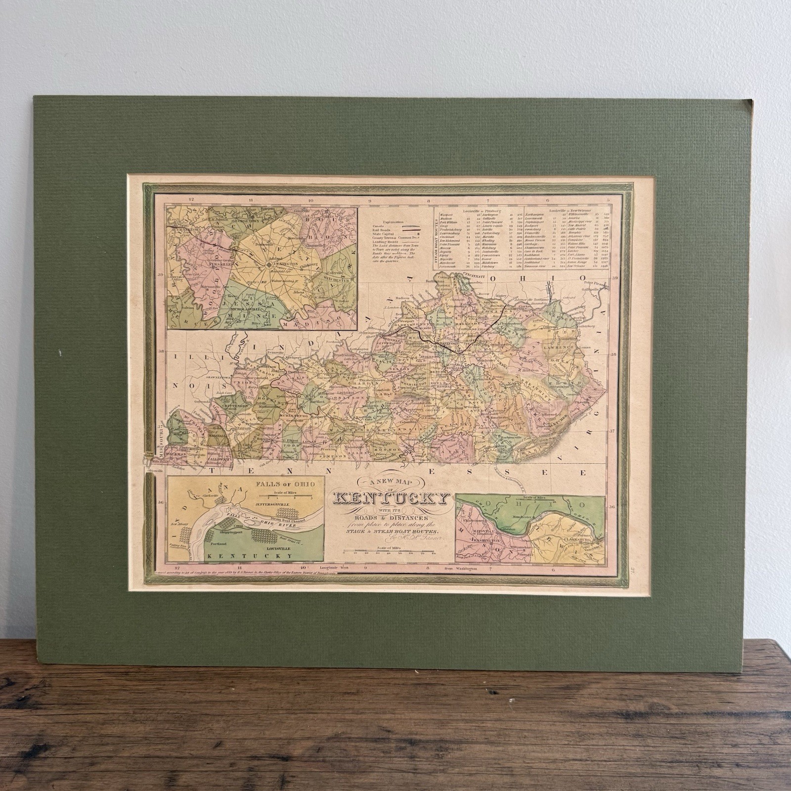
Original antique hand-colored engraved map in good to very good visible condition for its age. Displays expected age-related toning, scattered foxing and small spots. The visible map area remains bright, detailed and highly presentable with strong original coloring. No major tears or losses are visible while positioned inside the board.
The map is held loosely between a removable mat and backing board. It is not glued, taped or permanently mounted and slides freely from the enclosure. It was left inside the board for protection and photography, so the complete margins and reverse have not been closely inspected. The mat and backing board have edge, corner and surface wear. Please examine all photographs carefully.
Original 1839 hand-colored engraved map titled:
“A New Map of Kentucky with its Roads & Distances from Place to Place Along the Stage & Steam Boat Routes”
Created by noted American cartographer Henry Schenck Tanner and originally published in Philadelphia for Tanner’s 1839 New Universal Atlas.
This detailed pre-Civil War map depicts Kentucky divided into its period counties, with original hand-applied pastel coloring. It identifies towns, county seats, roads, railroads, canals, rivers, geographic features and travel distances throughout the state.
A particularly desirable feature is the large steamboat-route table in the upper-right corner. It records period travel distances along two important river routes:
• Louisville to Pittsburgh
• Louisville to New Orleans
The map also includes detailed regional insets showing:
• Falls of the Ohio
• Louisville
• Portland and Shippingport
• Jeffersonville, Clarksville and New Albany
• Lexington and the surrounding region
• Mason and Lewis counties along the Ohio River
The Falls of the Ohio inset identifies the steamboat channel, canal, river islands and early settlements surrounding Louisville. The map is surrounded by Tanner’s decorative engraved border and carries an 1839 copyright line along the lower edge.
The visible engraved map image measures approximately 13 1/2 × 11 1/4 inches. The removable green mat and backing board measure approximately 20 1/2 × 16 1/4 inches.
The map is loose inside the protective board enclosure. It is not glued, taped or dry-mounted and can be removed for professional framing. It was intentionally left in place for protection and photography.
Condition:
The visible map area shows expected age-related toning, scattered foxing and several small spots. The original hand coloring remains attractive and the engraved details are sharp. No major tears or missing sections are visible. Because the map was not completely removed from the board, its entire margins and reverse have not been closely inspected.
The green mat and backing board are included and exhibit scratches, rubbed edges, corner wear and other signs of age and storage.
Please review every photograph closely. The original antique map and removable protective board shown are the exact items the buyer will receive.
Keywords:
H S Tanner map, Henry Schenck Tanner, 1839 Kentucky map, antique Kentucky map, original hand colored map, stagecoach routes, steamboat routes, Louisville Kentucky, Falls of Ohio, Ohio River map, Louisville to New Orleans, Louisville to Pittsburgh, pre Civil War map, antebellum Kentucky, antique atlas map, historic railroad map, early American cartography, New Universal Atlas, Kentucky county map