Heat.net Store Home
|
1598 Sebastian Munster Rare Antique Map - Birds Eye View of London, England For Sale

When you click on links to various merchants on this site and make a purchase, this can result in this site earning a commission. Affiliate programs and affiliations include, but are not limited to, the eBay Partner Network.

1598 Sebastian Munster Rare Antique Map - Birds Eye View of London, England:
$1850.00
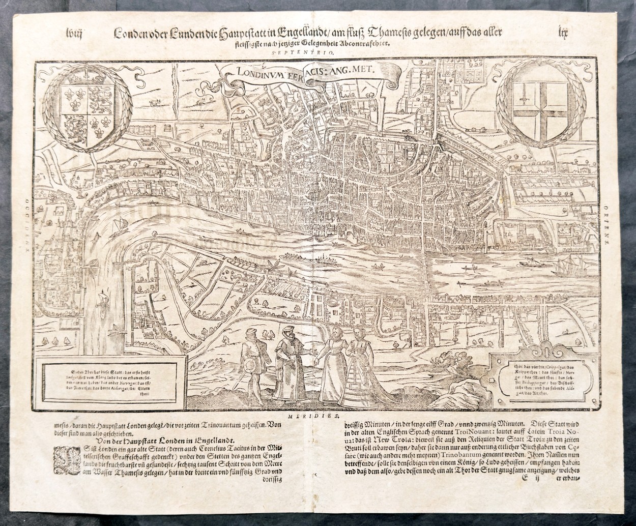
Londen oder Lunden die Hauptstatt in Engellandt / am fluß Thamesis gelegen/ auff das aller fleißsigste nach jetziger gelegenheit abcontrafehtet Cartographer : - Munster, Sebastian 1489 – 1552 - Date: - 1598
- Size: -15 1/4in x 12 1/2in (385mm x 315mm)
- Ref#: - 51012
- Condition: - (A+) Fine scarce original 1st edition antique woodcut birds eye view, is the third earliest acquirable depiction of London. Prepared in 1598, it was the only depiction of London to appear in Sebastian Munsters publication of Cosmographia, appearing in only the three last Sebastian Petri editions.
Modeled on Georg Braun and Franz Hogenberg's 1572 plan, the city here is laid out as a plan, but the buildings and surrounding landscape are presented in elevation - thus giving the impression of a bird's-eye view, even to the extent of detailing gardens and showing bustling river traffic. Also, as with the Braun and Hogenberg, the view has included four figures in the foreground: a nobleman and woman, with their attendant maid and footman (he, armed with a sword), each dressed in the styles of the period appropriate to their positions.. General Description:
Paper thickness and quality: - Heavy and stable
Paper color: -
Age of map color: -
Colors used: -
General color appearance: -
Paper size: - 15 1/4in x 12 1/2in (385mm x 315mm)
Plate size: - 15 1/4in x 12 1/2in (385mm x 315mm)
Margins: - Min 1/2in (12mm) Imperfections:
Margins: - Uniform age toning
Plate area: - Uniform age toning
Verso: - Uniform age toning Background:
Sebastian Munster's woodblock map of London is one of the earliest maps of the city available to collectors. It shows London during the lifetimes of Queen Elizabeth I and William Shakespeare. This map is a derivative of the Braun & Hogenberg's map of 1572. Munster has even arranged the costumed figures in the foreground into the same poses. Instead of the Latin descriptions found in the lower corners of the map on the Braun & Hogenberg map, Munster has instead included two panels listing the seven gates in the City wall, from west to east.
The old St Paul's Cathedral with its original pointed spire sits at the centre of the map. The spire was destroyed in a fire in 1561, but frequently appeared on later depictions of the city. The cathedral itself was burnt to the ground during the Great Fire of 1666, after which Christopher Wren designed and built the modern cathedral. To the southeast of St Paul's is the old London Bridge, the only bridge crossing over the River Thames until the 18th century.
South of the river are two circular arenas for bull and bear baiting. This was a vicious, but popular, form of entertainment in Tudor London. Shakespeare's Globe Theatre would be built in 1599 on a parcel of land to the west of these arenas.
Located outside of the City of London's jurisdiction, Southwark was a riotous pleasure ground where Londoners went to escape the strict rules north of the river.
On the far left of the map is Westminster, a separate royal enclave surrounding St James's Palace and Whitehall linked to the city by the Strand and by the river. A royal barge is shown on the river to the west of London Bridge, depicting the monarch's typical method of traveling to avoid the crowded streets of the city. The royal coat of arms is appropriately placed in the upper-left corner above Westminster, while the upper-right corner contains the coat of arms of the City of London.
Munster, Sebastian 1489 – 1552
German cartographer, cosmographer, and Hebrew scholar whose work Cosmographia (1544; Cosmography) was the earliest German description of the world and a major work in the revival of geographic thought in 16th-century Europe. It had numerous editions in different languages including Latin, French, Italian, English, and even Czech. Altogether, about 40 editions of the Cosmographia appeared between 1544 and 1628 and was one of the most successful and popular books of the 16th century. Münster was a major influence in popular thinking in Europe for the next 200 years.
This success was due not only to the level of descriptive detail but also to the fascinating full page maps & views as well as smaller woodcuts that were included in the text. Many of the woodcuts were executed by famous engravers of the time including Hans Holbein the Younger, Urs Graf, Hans Rudolph Manuel Deutsch, and David Kandel.
Aside from the well-known maps present in the Cosmographia, the text is thickly sprinkled with vigorous views: portraits of kings and princes, costumes and occupations, habits and customs, flora and fauna, monsters, wonders, and horrors about the known -- and unknown -- world, and was undoubtedly one of the most widely read books of its time.
Münster acquired the material for his book in three ways. Firstly he researched all available literary sources across Germany, Switzerland and other parts of Europe. Secondly he obtained original manuscript material from locals all over Europe for description of the countryside, cities, villages, towns, rivers and local history. Finally, he obtained further material first hand on his travels (primarily in south-west Germany, Switzerland, and Alsace). In 1588 Sebastian Petri re-released Cosomgraphia and re-issued many of Munsters maps and views in the \\\"copperplate style\\\". The maps in this release were more sophisticated than with earlier publications of Cosomgraphia and were based on the 1570 release of Abraham Ortelius monumental work Theatrum Orbis Terrarum.(Ref: Tooley; M&B)Please note all items saleed are genuine, we do not sell reproductions. A Certificate of Authenticity (COA) can be issued on request.
What is an Antique MapThe word Antique in the traditional sense refers to an item that is more than a hundred years old. In the past maps were sold in two forms, as a single sheet (broadsheet) or bound in an atlas or book. The majority of antique maps for sale today come from books or atlases and have survived due to the protection offered by the hardback covers.
When considering a purchase The first thing to determine when staring a collection or purchasing an item, is what is important to you. Most collectors prefer to build their collections around a theme. You may decide to collect maps from one region or country, charting its development through time. Similarly you could collect maps of one particular period in time, by type (i.e. sea or celestial charts) or by cartographer. The collector might also want to consider the theme of cartographical misconceptions such as California as an island or Australia as Terra Australis or the Great Southern Land.
The subject is so wide that any would-be-collector has almost endless possibilities to find his own little niche within the field, and thereby build a rewarding collection.
Starting a collection & pricingPricing is based on a number of different factors, the most important of which is regional. In any series of maps the most valuable are usually the World Map and the America/North America. The World because it is usually the most decorative and America because it has the strongest regional market. Other factors that come into play re: price is rarity, age, size, historical importance, decorative value (colour) and overall condition and quality of paper it is printed on.
As specialised dealers, we frequently work with first time map buyers who are just starting their collection. Guiding new collectors on their first antique map purchase and helping new collectors to focus their interests is one of the most rewarding aspects of being an rare map dealer. So please do not hesitate to contact us and we will be happy to help with any questions you may have.
Payment, Shipping & Return OptionsPlease click on the \"Shipping and Payments\" Tab above for shipping, payment and return details
About USClassical Images was founded 1998 and has built an excellent reputation for supplying high quality original antiquarian maps, historical atlases, antique books and prints. We carry an extensive inventory of antiquarian collectibles from the 15th to 19th century. Our collection typically includes rare books and decorative antique maps and prints by renowned cartographers, authors and engravers. Specific items not listed may be sourced on request.
Classical Images adheres to the Codes of Ethics outlined by the Antiquarian Booksellers Association of America (ABAA).
We are a primarily an online based enterprise, however our inventory may be viewed by appointment. Please call or email to arrange a viewing.
|
|
Other Related Items:
Related Items:
Antique 1598 Sebastian Munster Woodcut Map - Cosmographia Basle, Europe/Islands $750.00
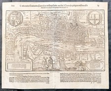
1598 Sebastian Munster Rare Antique Map - Birds Eye View of London, England $1850.00
1598 Sebastian Munster Antique Print Engravings to Text of Lucretia, Nero, Eagle $35.00
|
