When you click on links to various merchants on this site and make a purchase, this can result in this site earning a commission. Affiliate programs and affiliations include, but are not limited to, the eBay Partner Network.
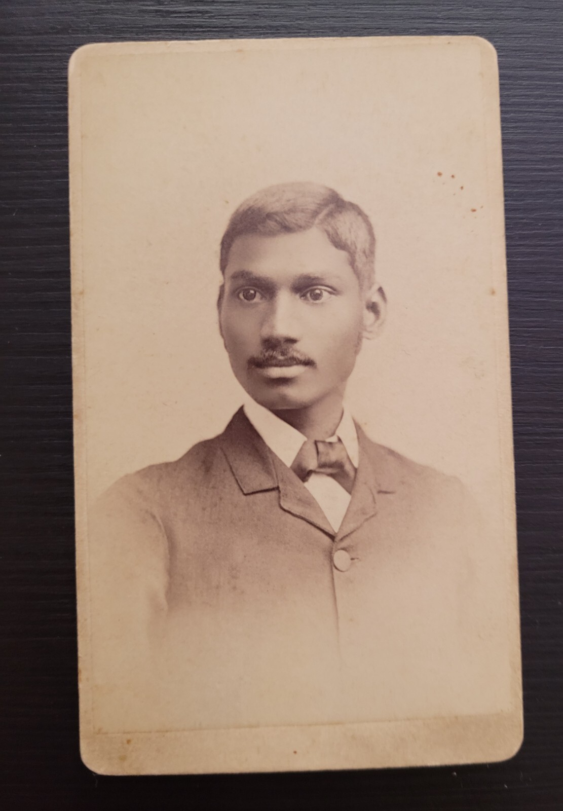
AN EXTREMELY RARE 1890S CDV
Scarce ethnic portrait of a Hindu man AUBURN NEW YORK.
Indians in the New York City metropolitan region constitute one of the largest and fastest growing ethnicities in the New York City metropolitan area of the United States. The New York City region is home to the largest Indian American population among metropolitan areas by a significant margin, enumerating 711,174 uniracial individuals by the 2013–2017 U.S. Census American Community Survey estimates.[7] The Asian Indian population also represents the second-largest metropolitan Asian national diaspora both outside of Asia and within the New York City metropolitan area, following the also rapidly growing and hemisphere-leading population of the estimated 893,697 uniracial Chinese in the New York City metropolitan area in 2017.[8] The U.S. state of New Jersey, most of whose population is situated within the New York City metropolitan region, has by a significant margin the highest proportional Indian population concentration of any U.S. state, with a Census-estimated 4.1% of New Jersey\'s population being an individual of Indian origin in 2017.[9]Contents1 History2 Demographics2.1 New York City boroughs2.2 Medium and small-sized cities, as of 2012 American Community Survey2.3 List of Little Indias2.3.1 In New Jersey2.3.1.1 Bombay, Jersey City2.3.2 In New York3 Culture3.1 Indian Independence Day Parade3.2 Arts, entertainment, and media3.2.1 News publications in English3.3 Languages3.4 Cuisine3.5 Religion3.6 Education3.6.1 Deepavali, Eid/Ramadan as school holidays3.7 Cricket4 Economic developments5 Airline connections with India and the Indian diaspora6 Notable people6.1 Business6.2 Education6.3 Entrepreneurship and technology6.4 Health6.5 Law, politics, and diplomacy6.6 Media6.7 Arts and culture7 See also8 ReferencesHistory
New India House, the home of the Indian Consulate-General in New York, on East 64th Street, in the Upper East Side Historic District of ManhattanThe first Indian to become a naturalised citizen was Bhicaji Balsara, a resident of New York.[10] However, this was after the Luce–Celler Act of 1946 that restored naturalization rights to Indian Americans in the United States.[11] A number of Indian Americans came to the U.S. via Indian communities from other countries, including the United Kingdom, Canada, South Africa, Mauritius, Malaysia, Singapore, Suriname, Guyana,[12] Trinidad and Tobago, Fiji, Kenya, Tanzania, Uganda, and Jamaica. The quota on Indian immigration was removed in the 1960s, leading to exponential growth in the number of Indian immigrants to the United States.[13] While Indians prior to this time were primarily involved in agricultural endeavors or constructing railroads in the western United States,[13] the largest number hereafter came to New York City and its affluent suburban environs, consisting largely of professionals, including physicians, engineers, financiers, scientists, entrepreneurs, and lawyers, as well as except the pink/lavender-illustrated counties compose the New York–Northern New Jersey–Long Island NY–NJ–PA Metropolitan Statistical Area, the most populous in the US: New York–Jersey City–White Plains, NY–NJ Metropolitan DivisionDutchess County–Putnam County, NY Metropolitan DivisionNassau County–Suffolk County, NY Metropolitan DivisionNewark, NJ–PA Metropolitan Division Remainder of the New York-Newark, NY–NJ–CT–PA Combined Statistical AreaThe New York-Newark-Bridgeport, NY-NJ-CT-PA Combined Statistical Area, consisting of New York City, Long Island, and adjacent areas within New York State, as well as nearby areas within the states of New Jersey (extending to Trenton), Connecticut (extending to Bridgeport), and including Pike County, Pennsylvania, was home to an estimated 711,174 Indian Americans as of the 2013–2017 American Community Survey by the U.S. Census Bureau,[7] comprising by far the largest Indian American population of any metropolitan area in the United States;[14] New York City itself also contains by far the highest Indian American population of any individual city in North America, estimated at 246,454 as of 2017.[15] At least twenty four Indian American enclaves characterized as a Little India have emerged in the New York City metropolitan area. As of December 2019, Indian airline carrier Air India as well as United States airline carrier United Airlines were offering direct flights from the New York City Metropolitan Area to and from Delhi and Mumbai. Delta Airlines inaugurated non-stop flight service from JFK International Airport to Mumbai in December 2019.
The Indian American population in the New York City metropolitan region was second in its population as an Asian ethnicity only to the approximately 893,697 uniracial Chinese New Yorkers as of 2017.[7][8] However, while the presence and growth of the Chinese population is focused on New York City and Long Island in New York State, the gravitas of the Indian population is roughly evenly split between New Jersey and New York State.[16][17]
Central New Jersey, at the geographic heart of the Northeast Megalopolis, has emerged as the largest hub for Indian immigrants to the U.S., followed closely by Queens and Nassau County on Long Island. Oak Tree Road in Edison and Iselin is known as an Indian dining and shopping destination.
Jersey City in New Jersey has the highest proportion of Asian Indians of any major U.S. city, comprising 10.9% of the overall population of Jersey City in 2010,[18] increasing to 11.4% by 2013.[19] Bergen County, New Jersey and Rockland County, New York are home to the highest concentrations of Malayalis outside of India.[20] Carteret, Middlesex County\'s Punjabi Sikh community, variously estimated at upwards of 3,000, is the largest concentration of Sikhs in New Jersey.[21] Smaller populations of Asian Indians reside in the Connecticut and Pennsylvania portions of the New York City metropolitan region. Monroe Township, Middlesex County, in central New Jersey, the geographic heart of the Northeast megalopolis, has displayed one of the fastest growth rates of its Indian population in the Western Hemisphere, increasing from 256 (0.9%) as of the 2000 Census[22] to an estimated 5,943 (13.6%) as of 2017,[23] representing a 2,221.5% (a multiple of 23) numerical increase over that period, including many affluent professionals and senior citizens. A community named Raajipo has emerged within nearby Robbinsville, in Mercer County, New Jersey, home of Swaminarayan Akshardham (Devnagari: स्वामिनारायण अक्षरधाम), inaugurated in 2014 as the world\'s largest Hindu temple.[24]
In 2014, 12,350 Indians legally immigrated to the New York-Northern New Jersey-Long Island, NY-NJ-PA core based statistical area;[25] in 2013, this number was 10,818;[26] in 2012, 10,550;[27] 11,256 in 2011;[28] and 11,388 in 2010.[29] These numbers do not include the remainder of the New York-Newark-Bridgeport, NY-NJ-CT-PA Combined Statistical Area. A study by the Pew Research Center found that in 2013, New Jersey was the only U.S. state in which immigrants born in India composed the largest foreign-born nationality, representing approximately 10% of all foreign-born residents in the state.[30]
New York City boroughsAs the city proper with the largest Asian Indian population in the United States by a wide margin, with an estimated 227,994 individuals as of the 2014 American Community Survey,[31] and as the primary destination for new Indian immigrants,[32] New York City is subdivided into official municipal boroughs, which themselves are home to significant Asian Indian and other South Asian populations. Note that this list includes neither the large Desi populations of Pakistani Americans, Bangladeshi Americans, and Sri Lankan Americans, nor Indo-Caribbean Americans, Afghan Americans, and others of South Asian origin who make their home in New York City.
Rank Borough City Indian Americans Density of Indian Americans per square mile Percentage of Indian Americans in municipality\'s population1 Queens (2014)[33] New York City 144,896 1,326.5 6.22 Brooklyn (2012) New York City 25,270 357.9 1.03 Manhattan (2012) New York City 24,359 1,060.9 1.54 The Bronx (2012) New York City 16,748 398.6 1.25 Staten Island (2012) New York City 6,646 113.6 1.4Total (2014)[31] New York City 227,994 753.4 2.7Medium and small-sized cities, as of 2012 American Community SurveyNew Jersey – (New Jersey, and Middlesex County in Central New Jersey), are home to by far the highest per capita Indian American populations of any U.S. state and U.S. county, respectively, at 3.9%[16] and 14.1%,[34] by 2013 U.S. Census estimates.
Carteret – 13.6%Cranbury CDP – 11.5%Cranbury Township – 10.5%East Windsor – 12.8%Edison – 28.3%Franklin – 14.6%Fords – 11.1%Iselin – 37.4%Monroe Township, New Jersey – 11.6% (2016)[35]North Brunswick – 18.3%Parsippany – 17.3%Piscataway – 18.3%Plainsboro – 29.5%Robbinsville CDP – 15.7%Secaucus – 11.1%South Brunswick – 27.1%West Windsor – 19.2%Woodbridge – 15.3%---
New York
Bellerose Terrace – 15.2%Garden City Park – 18.1%Herricks – 23.2%Hicksville – 11.7%Manhasset Hills – 18.3%Searingtown – 18%List of Little Indias
One of the most popular overseas branches of Saravanaa Bhavan, the world\'s largest Indian vegetarian restaurant chain, is located in Edison, Middlesex County, New Jersey.In New JerseyHudson CountyBombay, Jersey City, home of India SquareMercer CountyRobbinsville CDP (15.7% Asian Indian)[36]West Windsor (19.2% Asian Indian)[36]Middlesex County, with the highest percentage of Asian Indians of any U.S. county, at 13.9% in 2014[37]Monroe Township, with one of the fastest growth rates of its Indian population in the Western Hemisphere, increasing from 256 (0.9%) as of the 2000 Census[38] to an estimated 4,204 (10.0%) as of 2015,[39] representing a 1,542% (multiple of 16) numerical increase over that periodOak Tree Road, Edison (28.3% Asian Indian)[40]Oak Tree Road, Iselin (37.4% Asian Indian)[40]Plainsboro (29.5% Asian Indian)[36]Route 27, North Brunswick (18.3% Asian Indian)[36]Route 27, South Brunswick (27.1% Asian Indian)[36]Stelton Road, Piscataway (18.3% Asian Indian)[36]Woodbridge Township (15.3% Asian Indian)[36]Morris CountyRoute 46, Parsippany (17.3% Asian Indian)[36]Somerset CountyBridgewater, in the vicinity of a Hindu temple on the central and western parts of the townshipBombay, Jersey CityBombay,[1] in Jersey City, New Jersey, is home to the highest concentration of Asian Indians in the Western Hemisphere,[2] containing the rapidly growing Indian ethnic enclave of India Square. The neighborhood is centered on Newark Avenue, between Tonnele Avenue and JFK Boulevard, and is considered to be part of the larger Journal Square District. This area has been home to the largest outdoor Navratri festivities in New Jersey as well as several Hindu temples.[41] This portion of Newark Avenue is lined with grocery stores,[42] electronics vendors, video stores, import/export businesses, clothing stores, and restaurants, and is one of the busier pedestrian areas of this part of the city, often stopping traffic for hours. According to the 2000 census, there were nearly 13,000 Indians living in this two-block stretch of Jersey City, up from 3,000 in 1980, increasing commensurately between 2000 and 2010.[43] An annual, color-filled spring Holi festival has taken place in Jersey City since 1992, centered upon India Square and attracting significant participation and international media attention.[44][45] Although India Square continues to represent the heart of Little India in Jersey City, situated between Tonnele Avenue and John F. Kennedy Boulevard, Little India itself has been expanding further eastward along Newark Avenue, through Jersey City\'s Little Manila, to Summit Avenue and the Five Corners neighborhood.
In New YorkNassau County, Long IslandBellerose Terrace – 15.2%Broadway/Route 107, Old Country Road, Hicksville[46]Garden City Park – 18.1%Herricks – 23.2%Manhasset Hills – 18.3%Searingtown – 18%New York City With over 650,000 Indo Americans,[14] the New York City Metropolitan Area contains the largest metropolitan Asian Indian population in the Western Hemisphere.ManhattanLexington Avenue,[47] in the neighborhoods of Rose Hill and Murray Hill in Midtown Manhattan, between 25th and 30th Streets (growing preponderance of South Indian cuisine), has become known as Curry Hill,[48] developing rapidly as Manhattan\'s Indian population nearly doubled between the 2000 and 2010 Census[49] and has continued to increase, to a Census-estimated 27,289 in 2013.[50]East 6th Street,[51] in the East Village of Lower Manhattan, between 1st and 2nd Avenues, with many North Indian restaurants, and known as Curry Row.QueensFlushing, in the vicinity of the Hindu Temple Society of North AmericaHillside Avenue, Bellerose ManorHillside Avenue, Floral ParkHillside Avenue, Glen OaksHillside Avenue, Jamaica73rd and 74th Streets between Roosevelt and 37th Avenues, Jackson Heights, QueensCulture
New York City\'s annual India Day Parade, the world\'s largest Indian Independence Day parade outside India,[52] marches down Madison Avenue in Midtown Manhattan. The parade addresses controversial themes, including racism, sexism, corruption, and Bollywood.
The Hindu Temple Society of North America, representing Sri Maha Vallabha Ganapati Devasthanam is the oldest Hindu temple in the United States, in Flushing, Queens, at top. Further east on Long Island, in Melville, one of the world\'s largest BAPS temples opened in October 2016;[53]
Swaminarayan Akshardham (Devnagari: स्वामिनारायण अक्षरधाम) in Robbinsville, Mercer County, New Jersey, inaugurated in 2014 as the world\'s largest Hindu temple,[24] below.Indian Independence Day ParadeThe annual New York City India Day Parade, held on or approximately every August 15 since 1981, is the world\'s largest Indian Independence Day parade outside of India[52] and is hosted by The Federation of Indian Associations (FIA). According to the website of Baruch College of the City University of New York, \"The FIA, which came into being in 1970 is an umbrella organization meant to represent the diverse Indian population of NYC. Its mission is to promote and further the interests of its 500,000 members and to collaborate with other Indian cultural organization. The FIA acts as a mouth piece for the diverse Indian-Asian population in United States, and is focused on furthering the interests of this diverse community. The parade begins on East 38th Street and continues down Madison Avenue in Midtown Manhattan until it reaches 28th Street. At the review stand on 28th Street, the grand marshal and various celebrities greet onlookers. Throughout the parade, participants find themselves surrounded by the saffron, white and green colors of the Indian flag. They can enjoy Indian food, merchandise booths, live dancing and music present at the Parade. After the parade is over, various cultural organizations and dance schools participate in program on 23rd Street and Madison Avenue until 6PM.\"[54]
Arts, entertainment, and mediaIn September 2014, approximately 19,000 Indian Americans attended a speech delivered onstage by Indian Prime Minister Narendra Modi at Madison Square Garden in Midtown Manhattan.[55][56] This appearance was televised live worldwide and was estimated to have been watched by a billion-strong global audience of Indians in India and overseas. The annual Miss India USA pageant is headquartered in New York City and is often held in Middlesex County, New Jersey or on Long Island.[57]
News publications in EnglishIndia AbroadLittle IndiaNews India TimesThe Indian AmericanThe South Asian TimesTiranga in New JerseyLanguagesIndians in New York and New Jersey, as in the United States as a whole, are highly fluent in English. However, (Hindi (हिन्दी), Gujarati (ગુજરાતી), Marathi (मराठी),[58] Punjabi (ਪੰਜਾਬੀ), and Bengali (বাংলা)) and Tamil (தமிழ்), Telugu (తెలుగు), Malayalam (മലയാളം), and Kannada (ಕನ್ನಡ)), languages are spoken at home and with local media incorporating these languages available for viewership.[59] In Middlesex County, New Jersey, election ballots are printed in English, Spanish, Gujarati, Hindi, and Punjabi.[60]
CuisineIndian cuisine is very popular among Asian Indians in the United States. The growth in the New York City metropolitan region\'s Asian Indian populace has been accompanied by growth in the number of Indian restaurants, located both within and outside of traditional Indian enclaves, such that within New York City proper alone, there are hundreds of Indian restaurants.[61] According to David Shaftel of The New York Times in December 2014, the food at New York City\'s many chain restaurants is worthy of their flagships in India; the Midtown Manhattan neighborhood south of Murray Hill, namely Rose Hill, has been nicknamed Curry Hill, and provides an abundance of multinational India-based chains specializing in South Indian cuisine.[61]
In 1968, a family of Bengali brothers inaugurated the restaurant Shah Bag at 320 East 6th Street in the East Village of Lower Manhattan, followed by others, with the intention of \"making an Indian street\".[51] In time, this stretch of East 6th Street between First and Second Avenues evolved the nickname Curry Row, with a dense collection of North Indian restaurants.
ReligionParallelling India\'s religious constituency, most Indians in the New York City metropolitan region practice Hinduism, followed by Islam, Christianity, Sikhism, Buddhism, Jainism, Zorastrianism, Atheism, and irreligion. The Hindu Temple Society of North America in Flushing, Queens, is the oldest Hindu temple in the United States, and its canteen feeds 4,000 people a week, with as many as 10,000 during the Diwali (Deepavali) holiday.[62] Further east on Long Island, in Melville, one of the world\'s largest BAPS temples opened in October 2016.[53] Central New Jersey has large temples of Venkateswara and Guruvayurappan in Bridgewater and Morganville, respectively, and Sai Baba mandirs abound throughout the metropolitan area. BAPS also built the world\'s largest Hindu temple in Robbinsville, Mercer County, in Central New Jersey.[63] Numerous mosques, churches (geared significantly toward a Keralite membership), Sikh gurudwaras, and Jain temples are also situated in the New York City metropolitan area.
EducationIndians have been attaining school board membership positions on various boards of education in New Jersey and on Long Island.
Deepavali, Eid/Ramadan as school holidaysMomentum has been growing to recognize the Hindu holy day Deepavali (Diwali) as a holiday on school district calendars in the New York City metropolitan region.[64][65] Passaic, New Jersey established Diwali as a school holiday in 2005.[64][65] South Brunswick, New Jersey in 2010 became the first of the many school districts with large Indian student populations in Middlesex County to add Diwali to the school calendar.[65] Glen Rock, New Jersey in February 2015 became the first municipality in Bergen County, with its own burgeoning Indian population post-2010,[36][66] to recognize Diwali as an annual school holiday,[67][68] while thousands in Bergen County celebrated the first U.S. county-wide Diwali Mela festival under a unified sponsorship banner in 2016.[69] Diwali/Deepavali is also recognized by Monroe Township, New Jersey.
Efforts have been undertaken in Millburn,[64] Monroe Township, West Windsor-Plainsboro, Bernards Township, and North Brunswick, New Jersey,[65] Long Island, as well as in New York City,[70][71] among other school districts in the metropolitan region, to make Diwali a holiday on the school calendar. According to the Star-Ledger, Edison, New Jersey councilman Sudhanshu Prasad has noted parents\' engagement in making Deepavali a holiday there; while in Jersey City, the four schools with major Asian Indian populations mark the holiday by inviting parents to the school buildings for festivities.[65]
In March 2015, New York City Mayor Bill de Blasio officially declared the Muslim holy days Eid al-Fitr and Eid al-Adha holidays on the school calendar.[70] School districts in Paterson and South Brunswick, New Jersey observe Ramadan.[65]
CricketCricket is one of the fastest-growing sports in the New York City metropolitan region. In 2016, a public park was expanded in Monroe Township, Middlesex County in central New Jersey to accommodate a designated cricket pitch, among other recreational facilities.[72] There are similar facilities available in Mercer County Park in West Windsor.[73]
Economic developmentsFurther information: Tech companies in the New York metropolitan area and Biotech and pharmaceutical companies in the New York metropolitan areaIndian pharmaceutical companies are coming to New Jersey to gain a foothold in the United States.[74] Dr. Reddy\'s Laboratories, based in Hyderabad, set up its U.S. headquarters in Princeton, New Jersey.[75] Kitex Garments, based in Kerala and India\'s largest children\'s clothing manufacturer, opened its first U.S. office in Montvale, New Jersey in October 2015.[76] Pharmaceutical company Aurobindo, also headquartered in Hyderabad, has established its U.S. headquarters in the Dayton section of South Brunswick, Middlesex County, New Jersey, and is implementing a multimillion-dollar expansion of these Central New Jersey operations.[77]
Airline connections with India and the Indian diasporaA majority of Indian Americans in the New York region are recent immigrants or children of such from India. In that context, travel between the United States and India has developed strong cultural connections, and, in more recent years, business traffic for expatriates. Air India operates nonstop flights from New York JFK to Delhi and Newark Liberty International Airport to Mumbai. United Airlines also operates a nonstop flight from Newark to Mumbai.[78] Meanwhile, Singapore Airlines flies to Singapore, where Tamil is one of the official state languages, both from Newark (with one of the longest non-stop flights in the world[79][80]) and from New York JFK. In May 2019, Delta Air Lines announced non-stop flight service between JFK and Mumbai, to begin on December 22, 2019.[81]
Notable people
Aziz AnsariRavinder BhallaPreet BhararaSant Singh ChatwalUpendra ChivukulaDeepak ChopraNina DavuluriRhona FoxVin GopalGurbir GrewalRohit GuptaNikki HaleyPoorna JagannathanAnshu JainMindy KalingAshok KondaboluHari KondaboluPadma LakshmiSandeep MathraniSiddhartha MukherjeeIndra NooyiVikram PanditKal PennRachel RoyRakesh SatyalReshma SaujaniRaj ShahRuchir SharmaSimran Jeet SinghHari SreenivasanSreenath SreenivasanHimanshu SuriRoopa UnnikrishnanAli VelshiRohit Vyas
Indian New Yorkers and New JerseyansBusinessLakshman Achuthan – co-founder, Economic Cycle Research Institute[82]Anu Aiyengar – global co-head of North American mergers and acquisitions at JPMorgan Chase & Co[83]Anirvan Banerji – co-founder, Economic Cycle Research Institute,[82] columnist and director of research, Bloomberg News[84]Ajaypal Singh Banga – CEO, MasterCard, Purchase, Westchester County, New YorkSant Singh Chatwal – founder of numerous hotel brands including The Chatwal, Dream Hotels, and Time Hotels.Arvind Krishna – CEO, IBM, Armonk, New YorkSandeep Mathrani – CEO, WeWorkRaghavan Mayur – president, TechnoMetrica Market Intelligence, Ramsey, Bergen County, New Jersey[85]Laxman Narasimhan – CEO of Reckitt Benckiser, in Greenwich, ConnecticutIndra Nooyi – CEO of PepsiCo, Purchase, New YorkVikram Pandit – former CEO of CitigroupAjit Jain – president, Berkshire Hathaway Reinsurance Group[86][87]Anshu Jain – business executive who formerly served as the Co-CEO of Deutsche Bank from 2012 until 2015 and is currently serving as president at Cantor FitzgeraldSavita Subramanian – head of United States equity and quantitative strategy, Bank of America Merrill Lynch[88]Rahul Merchant – CIO of TIAA[89]Ruchir Sharma – economist, chief global strategist of asset management and emerging markets equity, Morgan Stanley Investment ManagementEducationMeena Bose – director of the Peter S. Kalikow Center for the Study of the American Presidency at Hofstra University, Nassau County, Long Island[90]Srinivas Dhulipala – member, Board of Education, Alpine, Bergen County, New Jersey, elected in November 2017[91]Sanjiv Ohri – trustee and vice president, Board of Education, Glen Rock, Bergen County, New Jersey[67][68]Falguni Patel – member, Board of Education, Edison, Middlesex County, New Jersey, elected in November 2017[92]Katepalli Sreenivasan – academic dean of New York University Tandon School of EngineeringRaghu Sundaram – Dean of New York University Stern School of BusinessEntrepreneurship and technologyPayal Kadakia – CEO and co-founder of ClassPass[93]Dhairya Dand – inventor, artist, and designer[94]Vikram Joshi – CTO and co-founder of Pulsd[95][96]Roopa Unnikrishnan – innovation consultantHealthDeepak Chopra – physician, alternative medicine advocate, public speaker, author[97]Usha George, RN, MS – president, Indian Nurses Association of New York, 2013–2014[98]Siddhartha Mukherjee – hematologist and oncologist, scientist, and Pulitzer Prize winner for General Non-FictionSamin K. Sharma – interventional cardiologist at Mount Sinai Hospital in Manhattan, holding the American record for the highest number of complex coronary interventions performed annually, along with the highest angioplasty success rate in New York State[99]Prabhjot Singh Dhadialla – MD, PhD – director, Arnhold Global Health Institute, Mount Sinai Hospital[100]Law, politics, and diplomacySyed Akbaruddin – Permanent Representative of India to the United Nations[101]Harjinder S. Bahia – councilman, Carteret, Middlesex County, New Jersey[102]Ravinder Bhalla – mayor, Hoboken, Hudson County, New Jersey, the first turban-wearing Sikh American mayor in the United States to be elected by a municipality\'s residents, in November 2017[103]Preet Bharara – U.S. Attorney for the Southern District of New York, from 2009 to 2017Bhicaji Balsara – the first Indian to become a naturalized U.S. citizen, in 1909[10]Saikat Chakrabarti – chief of staff to Alexandria Ocasio-Cortez, the U.S. Representative from New York\'s 14th congressional district representing parts of the Bronx and Queens in New York CityUpendra J. Chivukula – Commissioner, New Jersey Board of Public Utilities since 2014; first Indian American elected to the New Jersey General Assembly in 2001, representing the 17th Legislative District straddling Middlesex and Somerset countiesVin Gopal – elected to the New Jersey Senate, representing the 11th Legislative District covering portions of Monmouth County, New Jersey in November 2017Gurbir Grewal – New Jersey\'s 61st State Attorney General and former Bergen County, New Jersey prosecutor and the first Sikh American county prosecutor in the U.S., sworn into office in 2016[104]Nikki Haley – 29th United States Ambassador to the United NationsReema Harrysingh-Carmona – economist and the 5th First Lady of Trinidad and TobagoSamip Joshi – township councilman, Edison, New Jersey, elected November 2017[92]Arati Kreibich – neurobiology researcher and the first Indian American to be elected to the Glen Rock, Bergen County, New Jersey borough council, in November 2017Hemant Marathe – electrical engineer and the first Indian American to be elected mayor of West Windsor, Mercer County, New Jersey, in November 2017[105]Raj Mukherji – Assemblyman from New Jersey\'s 33rd legislative district, spanning portions of Hudson County, elected in 2013Shanti Narra – first Indian American member, Board of Chosen Freeholders, Middlesex County, New Jersey, appointed in October 2016[106] and then elected in November 2017[92]Sudhanshu Prasad – councilman, Edison, New Jersey in 2015, and former chairman of the Department of Medicine, JFK Hospital, Edison[107]Reshma Saujani – attorney and politician, founder of the tech organization Girls Who CodeKapil Shah – councilman, Piscataway, Middlesex County, New Jersey[102]Raj Shah – White House Deputy Press Secretary, assumed office September 12, 2017Jaswinder Singh – councilman, Carteret, New Jersey[102]MediaSee also: New Yorkers in journalism and Media in New York CityJai Agnish – journalist, NorthJersey.com, part of the USA TODAY network[108]Vikas Bajaj – journalist, The New York Times[109]Shunondo Basu – meteorologist, gas analyst, Bloomberg News[110]Niraj Chokshi – business journalist, The New York Times[111]Jay Dabhi – radio disc jockey[112][113]Aswath Damodaran – economic journalist and professor at New York University Stern School of BusinessNina Davuluri – Miss America 2014, public advocate for STEM fields and cultural diversityRajeev Dhir – multimedia journalist[114]Chhavi Dublish – BBCRhona Fox – founder, soca music record label Fox FuseMeera Jagannathan – journalist, New York Daily News[115]Sukanya Krishnan – news anchor, WNYW Fox 5Devika Krishna Kumar – journalist, energy and commodities markets reporter, Thomson Reuters[116]Padma Lakshmi – television host, cookbook author, actress, and modelSapna Maheshwari – business journalist, The New York Times[117]Apoorva Mandavilli – health and science journalist, The New York Times;[118] and founding editor-in-chief of the autism news site SpectrumManish Mehta – journalist, New York Daily News[119]Seema Mody – journalist, CNBC[120]Vinita Nair – television journalistSridhar Natarajan – journalist, Bloomberg News[121]Kesal Patel – head of video, Dow Jones & Company[122]Anushka Patil – social strategies editor, The New York Times[123]Neha Prakash – journalist, Mashable[124]Nidhi Prakash – journalist, BuzzFeed News[125]Anita Raghavan – journalist, The New York Times; author, The Billionaire\'s Apprentice[126]Shalini Ramachandran – journalist, The Wall Street Journal[127]Vandana Rambaran – journalist, Fox News[128][129]Reena Roy – journalist, WCBS-TV[130]Somini Sengupta – United Nations bureau chief, The New York Times[131]Anjali Singhvi – graphics and multimedia editor, The New York Times[132]Simran Jeet Singh – journalist, Religion News ServiceRavi Somaiya – journalist, The New York Times[133]Hari Sreenivasan – journalist, anchor, PBS NewsHour WeekendSreenath Sreenivasan – technology journalistAarthi Swaminathan – Yahoo! Finance[134]Arun Venugopal – reporter, WNYC, and journalist, The New York Times[135]Shivani Vora – journalist, The New York Times[62]Ali Velshi – journalist, MSNBCRohit Vyas – journalistFareed Zakaria – journalist, author, and television host, CNNArts and cultureWaris Ahluwalia – fashion designer, actor, and model[136]Aziz Ansari – actor, comedianBala Devi Chandrashekar – Bharatanatyam dancerTerry Gajraj – singerRohit Gupta – filmmakerHasan Minhaj – actor, comedianPoorna Jagannathan – actress[137]Norah Jones (Geetali Norah Jones Shankar)[138] – singer-songwriter, musician, and actressMindy Kaling (Vera Mindy Chokalingam) – actress, comedian, writer, and producerVikas Khanna – Michelin Star Chef, Restaurateur, author, Filmmaker and Humanitarian.Rajika Puri – dance-theater artist & curator[139]Ashok Kondabolu – internet personalityHari Kondabolu – comedianRachel Roy – fashion designerRakesh Satyal – novelistEmily Shah – Miss New Jersey USA 2014Suraj Sharma – actorHimanshu Suri – rapperChhavi Verg – Miss New Jersey USA 2017[140]Utsav Lal – pianist,composer, educatorSee alsoflag New York City portalflag India portalAsian Americans in New York CityChinese people in New York CityBangladeshis in New York CityDemographics of New York CityFilipinos in the New York metropolitan areaFuzhounese in New York CityJapanese in New York CityKoreans in New York CityRussians in New York CityTaiwanese people in New York CityBrooklyn (/ˈbrʊklɪn/) is a borough of New York City, coterminous with Kings County, in the U.S. state of New York. It is the most-populous county in the state, the second-most densely populated county in the United States,[5] and New York City\'s most populous borough, with an estimated 2,648,403 residents in 2020.[6] Named after the Dutch village of Breukelen, it shares a land border with the borough of Queens at the western end of Long Island. Brooklyn has several bridge and tunnel connections to the borough of Manhattan across the East River, and the Verrazzano-Narrows Bridge connects it with Staten Island.
With a land area of 70.82 square miles (183.4 km2) and water area of 26 square miles (67 km2), Kings County is New York state\'s fourth-smallest county by land area and third-smallest by total area, though it is the second-largest among the city\'s five boroughs in terms of area and largest in terms of population.[7] If each borough were ranked as a city, Brooklyn would rank as the third-most populous in the U.S., after Los Angeles and Chicago.
Brooklyn was an independent incorporated city (and previously an authorized village and town within the provisions of the New York State Constitution) until January 1, 1898, when, after a long political campaign and public relations battle during the 1890s, according to the new Municipal Charter of \"Greater New York\", Brooklyn was consolidated with other cities, towns, and counties to form the modern City of New York, surrounding the Upper New York Bay with five constituent boroughs. The borough continues, however, to maintain a distinct culture. Many Brooklyn neighborhoods are ethnic enclaves. Brooklyn\'s official motto, displayed on the Borough seal and flag, is Eendraght Maeckt Maght, which translates from early modern Dutch as \"Unity makes strength\".
In the first decades of the 21st century, Brooklyn has experienced a renaissance as an avant-garde destination for hipsters,[8] with concomitant gentrification, dramatic house price increases and a decrease in housing affordability.[9] Since the 2010s, Brooklyn has evolved into a thriving hub of entrepreneurship, high technology startup firms,[10][11] postmodern art[12] and design.[11]Contents1 Etymology2 History2.1 Colonial era2.2 Post-colonial era2.3 New York City borough3 Geography3.1 Boroughscape3.2 Climate4 Demographics4.1 2010 Census4.2 2018 estimates4.3 Languages5 Neighborhoods5.1 Community diversity6 Government and politics6.1 Federal representation7 Economy8 Culture8.1 Cultural venues8.2 Media8.3 Events9 Parks and other attractions9.1 Sports10 Transportation10.1 Public transport10.2 Roadways10.3 Waterways11 Education11.1 Higher education12 Brooklyn Public Library13 Partnerships with districts of foreign cities14 Hospitals and healthcare15 See also15.1 General links15.2 History of neighborhoods15.3 General history16 Notes17 References18 Further reading18.1 Published 1950–present18.2 Published until 194919 External links19.1 HistoryNew York City\'s five boroughsvteJurisdiction Population Gross Domestic Product Land area DensityBorough County Estimate(2019)[13] billions(2012 US$)[14] per capita(US$) squaremiles squarekm persons /sq. mi persons /km2The BronxBronx1,418,207 42.695 30,100 42.10 109.04 33,867 13,006BrooklynKings2,559,903 91.559 35,800 70.82 183.42 36,147 13,957ManhattanNew York1,628,706 600.244 368,500 22.83 59.13 71,341 27,544QueensQueens2,253,858 93.310 41,400 108.53 281.09 20,767 8,018Staten IslandRichmond476,143 14.514 30,500 58.37 151.18 8,157 3,150City of New York8,336,817 842.343 101,000 302.64 783.83 27,547 10,636State of New York19,453,561 1,731.910 89,000 47,126.40 122,056.82 412 159Sources:[15] and see individual borough articlesEtymologyThe name Brooklyn is derived from the original Dutch colonial name Breuckelen. The oldest mention of the settlement in the Netherlands, is in a charter of 953 of Holy Roman Emperor Otto I, namely Broecklede.[16] This is a composition of the two words broeck, meaning bog or marshland and lede, meaning small (dug) water stream specifically in peat areas.[17] Breuckelen in the American continent is established in 1646, the name first appeared in print in 1663.[18] The Dutch colonists named it after the scenic town of Breukelen, Netherlands.[19][20] Over the past two millennia, the name of the ancient town in Holland has been Bracola, Broccke, Brocckede, Broiclede, Brocklandia, Broekclen, Broikelen, Breuckelen and finally Breukelen.[21] The New Amsterdam settlement of Breuckelen also went through many spelling variations, including Breucklyn, Breuckland, Brucklyn, Broucklyn, Brookland, Brockland, Brocklin, and Brookline/Brook-line. There have been so many variations of the name that its origin has been debated; some have claimed breuckelen means \"broken land\".[22] The final name of Brooklyn, however, is the most accurate to its meaning.[23][24]
HistoryPart of a series of articles onLong cultureRecreationLaw CountySuffolk CountyMunicipalitiesNorth ShoreSouth ShoreNorth ForkSouth ForkLong Island SoundBarrier islandsvteNew Netherland series
Brooklyn Museum – Hooker\'s Map of the Village of BrooklynSee also: Timeline of BrooklynThe history of European settlement in Brooklyn spans more than 350 years. The settlement began in the 17th century as the small Dutch-founded town of \"Breuckelen\" on the East River shore of Long Island, grew to be a sizeable city in the 19th century, and was consolidated in 1898 with New York City (then confined to Manhattan and part of the Bronx), the remaining rural areas of Kings County, and the largely rural areas of Queens and Staten Island, to form the modern City of New York.
Colonial eraSix Dutch townsThe Dutch were the first Europeans to settle Long Island\'s western edge, which was then largely inhabited by the Lenape, an Algonquian-speaking American Indian tribe often referred to in colonial documents by a variation of the place name \"Canarsie\". Bands were associated with place names, but the colonists thought their names represented different tribes. The Breuckelen settlement was named after Breukelen in the Netherlands; it was part of New Netherland. The Dutch West India Company lost little time in chartering the six original parishes (listed here by their later English town names):[25]
Gravesend: in 1645, settled under Dutch patent by English followers of Anabaptist Deborah Moody, named for \'s-Gravenzande, Netherlands, or Gravesend, EnglandBrooklyn Heights: as Breuckelen in 1646, after the town now spelled Breukelen, Netherlands. Breuckelen was along Fulton Street (now Fulton Mall) between Hoyt Street and Smith Street (according to H. Stiles and P. Ross). Brooklyn Heights, or Clover Hill, is where the village of Brooklyn was founded in 1816.Flatlands: as Nieuw Amersfoort in 1647Flatbush: as Midwout in 1652Nieuw Utrecht: in 1657, after the city of Utrecht, NetherlandsBushwick: as Boswijck in 1661
A typical dining table in the Dutch village of Brooklyn, c. 1664, from The Brooklyn Museum.The colony\'s capital of New Amsterdam, across the East River, obtained its charter in 1653. The neighborhood of Marine Park was home to North America\'s first tide mill. It was built by the Dutch, and the foundation can be seen today. But the area was not formally settled as a town. Many incidents and documents relating to this period are in Gabriel Furman\'s 1824 compilation.[26]
Six townships in an English province
Village of Brooklyn and environs, 1766What is now Brooklyn today left Dutch hands after the final English conquest of New Netherland in 1664, a prelude to the Second Anglo-Dutch War. New Netherland was taken in a naval action, and the conquerors renamed their prize for the overall English naval commander, James, Duke of York, brother of the then monarch King Charles II of England and future king himself as King James II of England and James VII of Scotland; Brooklyn became a part of the new English and later British colony, the Province of New York.
The English reorganized the six old Dutch towns on southwestern Long Island as Kings County on November 1, 1683,[27] one of the \"original twelve counties\" then established in New York Province. This tract of land was recognized as a political entity for the first time, and the municipal groundwork was laid for a later expansive idea of Brooklyn identity.
Lacking the patroon and tenant farmer system established along the Hudson River Valley, this agricultural county unusually came to have one of the highest percentages of slavery among the population in the \"Original Thirteen Colonies\" along the Atlantic Ocean eastern coast of North America.[28]
Revolutionary WarFurther information: Battle of Long Island and New York and New Jersey campaign
The Battle of Long Island was fought across Kings County.On August 27, 1776, was fought the Battle of Long Island (also known as the \'Battle of Brooklyn\'), the first major engagement fought in the American Revolutionary War after independence was declared, and the largest of the entire conflict. British troops forced Continental Army troops under George Washington off the heights near the modern sites of Green-Wood Cemetery, Prospect Park, and Grand Army Plaza.[29]
Washington, viewing particularly fierce fighting at the Gowanus Creek from atop a hill near the west end of present-day Atlantic Avenue, was famously reported to have emotionally exclaimed: \"What brave men I must this day lose!\".[29]
The fortified American positions at Brooklyn Heights consequently became untenable and were evacuated a few days later, leaving the British in control of New York Harbor. While Washington\'s defeat on the battlefield cast early doubts on his ability as the commander, the tactical withdrawal of all his troops and supplies across the East River in a single night is now seen by historians as one of his most brilliant triumphs.[29]
The British controlled the surrounding region for the duration of the war, as New York City was soon occupied and became their military and political base of operations in North America for the remainder of the conflict. The British generally enjoyed a dominant Loyalist sentiment from the residents in Kings County who did not evacuate, though the region was also the center of the fledgling—and largely successful—American intelligence network, headed by Washington himself.
The British set up a system of notorious prison ships off the coast of Brooklyn in Wallabout Bay, where more American patriots died of intentional neglect than died in combat on all the battlefields of the American Revolutionary War, combined. One result of the Treaty of Paris in 1783 was the evacuation of the British from New York City, celebrated by residents into the 20th century.
Post-colonial eraUrbanization
A preindustrial Winter Scene in Brooklyn, c. 1819–20, by Francis Guy (Brooklyn Museum).The first half of the 19th century saw the beginning of the development of urban areas on the economically strategic East River shore of Kings County, facing the adolescent City of New York confined to Manhattan Island. The New York Navy Yard operated in Wallabout Bay (border between Brooklyn and Williamsburgh) during the 19th century and two-thirds of the 20th century.
The first center of urbanization sprang up in the Town of Brooklyn, directly across from Lower Manhattan, which saw the incorporation of the Village of Brooklyn in 1817. Reliable steam ferry service across the East River to Fulton Landing converted Brooklyn Heights into a commuter town for Wall Street. Ferry Road to Jamaica Pass became Fulton Street to East New York. Town and Village were combined to form the first, kernel incarnation of the City of Brooklyn in 1834.
In a parallel development, the Town of Bushwick, farther up the river, saw the incorporation of the Village of Williamsburgh in 1827, which separated as the Town of Williamsburgh in 1840 and formed the short-lived City of Williamsburgh in 1851. Industrial deconcentration in the mid-century was bringing shipbuilding and other manufacturing to the northern part of the county. Each of the two cities and six towns in Kings County remained independent municipalities and purposely created non-aligning street grids with different naming systems.
However, the East River shore was growing too fast for the three-year-old infant City of Williamsburgh; it, along with its Town of Bushwick hinterland, was subsumed within a greater City of Brooklyn in 1854.
By 1841, with the appearance of The Brooklyn Eagle, and Kings County Democrat published by Alfred G. Stevens, the growing city across the East River from Manhattan was producing its own prominent newspaper.[30] It later became the most popular and highest circulation afternoon paper in America. The publisher changed to L. Van Anden on April 19, 1842,[31] and the paper was renamed The Brooklyn Daily Eagle and Kings County Democrat on June 1, 1846.[32] On May 14, 1849, the name was shortened to The Brooklyn Daily Eagle;[33] on September 5, 1938, it was further shortened to Brooklyn Eagle.[34] The establishment of the paper in the 1840s helped develop a separate identity for Brooklynites over the next century. The borough\'s soon-to-be-famous National League baseball team, the Brooklyn Dodgers, also assisted with this. Both major institutions were lost in the 1950s: the paper closed in 1955 after unsuccessful attempts at a sale following a reporters\' strike, and the baseball team decamped for Los Angeles in a realignment of major league baseball in 1957.
Agitation against Southern slavery was stronger in Brooklyn than in New York,[35] and under Republican leadership, the city was fervent in the Union cause in the Civil War. After the war the Henry Ward Beecher Monument was built downtown to honor a famous local abolitionist. A great victory arch was built at what was then the south end of town to celebrate the armed forces; this place is now called Grand Army Plaza.
The number of people living in Brooklyn grew rapidly early in the 19th century. There were 4,402 by 1810, 7,175 in 1830 and 15,396 by 1830.[36] The city\'s population was 25,000 in 1834, but the police department comprised only 12 men on the day shift and another 12 on the night shift. Every time a rash of burglaries broke out, officials blamed burglars from New York City. Finally, in 1855, a modern police force was created, employing 150 men. Voters complained of inadequate protection and excessive costs. In 1857, the state legislature merged the Brooklyn force with that of New York City.[37]
Civil War
\"Any Thing for Me, if You Please?\" Post Office, 1864Fervent in the Union cause, the city of Brooklyn played a major role in supplying troops and materiel for the American Civil War. The most well-known regiment to be sent off to war from the city was the 14th Brooklyn \"Red Legged Devils\". They fought from 1861 to 1864, wore red the entire war, and were the only regiment named after a city. President Lincoln called them into service, making them part of a handful of three-year enlisted soldiers in April 1861. Unlike other regiments during the American Civil War, the 14th wore a uniform inspired by the French Chasseurs, a light infantry used for quick assaults.
As a seaport and a manufacturing center, Brooklyn was well prepared to contribute to the Union\'s strengths in shipping and manufacturing. The two combined in shipbuilding; the ironclad Monitor was built in Brooklyn.
Twin cityBrooklyn is referred to as the twin city of New York in the 1883 poem, \"The New Colossus\" by Emma Lazarus, which appears on a plaque inside the Statue of Liberty. The poem calls New York Harbor \"the air-bridged harbor that twin cities frame\". As a twin city to New York, it played a role in national affairs that was later overshadowed by its century-old submergence into its old partner and rival.
Economic growth continued, propelled by immigration and industrialization, and Brooklyn established itself as the third-most populous American city for much of the 19th century. The waterfront from Gowanus Bay to Greenpoint was developed with piers and factories. Industrial access to the waterfront was improved by the Gowanus Canal and the canalized Newtown Creek. USS Monitor was the most famous product of the large and growing shipbuilding industry of Williamsburg. After the Civil War, trolley lines and other transport brought urban sprawl beyond Prospect Park and into the center of the county.Brooklyn Bridge in 1883, by Currier and IvesThe rapidly growing population needed more water, so the City built centralized waterworks including the Ridgewood Reservoir. The municipal Police Department, however, was abolished in 1854 in favor of a Metropolitan force covering also New York and Westchester Counties. In 1865 the Brooklyn Fire Department (BFD) also gave way to the new Metropolitan Fire District.
Throughout this period the peripheral towns of Kings County, far from Manhattan and even from urban Brooklyn, maintained their rustic independence. The only municipal change seen was the secession of the eastern section of the Town of Flatbush as the Town of New Lots in 1852. The building of rail links such as the Brighton Beach Line in 1878 heralded the end of this isolation.Borough of Brooklyn wards, 1900Sports became big business, and the Brooklyn Bridegrooms played professional baseball at Washington Park in the convenient suburb of Park Slope and elsewhere. Early in the next century, under their new name of Brooklyn Dodgers, they brought baseball to Ebbets Field, beyond Prospect Park. Racetracks, amusement parks, and beach resorts opened in Brighton Beach, Coney Island, and elsewhere in the southern part of the county.Currier and Ives print of Brooklyn, 1886.Toward the end of the 19th century, the City of Brooklyn experienced its final, explosive growth spurt. Railroads and industrialization spread to Bay Ridge and Sunset Park. Within a decade, the city had annexed the Town of New Lots in 1886, the Town of Flatbush, the Town of Gravesend, the Town of New Utrecht in 1894, and the Town of Flatlands in 1896. Brooklyn had reached its natural municipal boundaries at the ends of Kings County.
Mayors of the City of BrooklynSee also: List of mayors of New York City and Brooklyn borough presidentsBrooklyn elected a mayor from 1834 until consolidation in 1898 into the City of Greater New York, whose own second mayor (1902–1903), Seth Low, had been Mayor of Brooklyn from 1882 to 1885. Since 1898, Brooklyn has, in place of a separate mayor, elected a Borough President.
Mayors of the City of Brooklyn[38]Mayor Party Start year End yearGeorge Hall Democratic-Republican 1834 1834Jonathan Trotter Democratic 1835 1836Jeremiah Johnson Whig 1837 1838Cyrus P. Smith Whig 1839 1841Henry C. Murphy Democratic 1842 1842Joseph Sprague Democratic 1843 1844Thomas G. Talmage Democratic 1845 1845Francis B. Stryker Whig 1846 1848Edward Copland Whig 1849 1849Samuel Smith Democratic 1850 1850Conklin Brush Whig 1851 1852Edward A. Lambert Democratic 1853 1854George Hall Know Nothing 1855 1856Samuel S. Powell Democratic 1857 1860Martin Kalbfleisch Democratic 1861 1863Alfred M. Wood Republican 1864 1865Samuel Booth Republican 1866 1867Martin Kalbfleisch Democratic 1868 1871Samuel S. Powell Democratic 1872 1873John W. Hunter Democratic 1874 1875Frederick A. Schroeder Republican 1876 1877James Howell Democratic 1878 1881Seth Low Republican 1882 1885Daniel D. Whitney Democratic 1886 1887Alfred C. Chapin Democratic 1888 1891David A. Boody Democratic 1892 1893Charles A. Schieren Republican 1894 1895Frederick W. Wurster Republican 1896 1897New York City boroughFurther information: History of New York City (1898–1945)
Brooklyn in 1897In 1883, the Brooklyn Bridge was completed, transportation to Manhattan was no longer by water only, and the City of Brooklyn\'s ties to the City of New York were strengthened.
The question became whether Brooklyn was prepared to engage in the still-grander process of consolidation then developing throughout the region, whether to join with the county of New York, the county of Richmond and the western portion of Queens County to form the five boroughs of a united City of New York. Andrew Haskell Green and other progressives said Yes, and eventually, they prevailed against the Daily Eagle and other conservative forces. In 1894, residents of Brooklyn and the other counties voted by a slight majority to merge, effective in 1898.[39]
Kings County retained its status as one of New York State\'s counties, but the loss of Brooklyn\'s separate identity as a city was met with consternation by some residents at the time. Many newspapers of the day called the merger the \"Great Mistake of 1898\", and the phrase still denotes Brooklyn pride among old-time of Brooklyn (red) within New York City (remainder white)Brooklyn is 97 square miles (250 km2) in area, of which 71 square miles (180 km2) is land (73%), and 26 square miles (67 km2) is water (27%); the borough is the second-largest inland area among the New York City\'s boroughs. However, Kings County, coterminous with Brooklyn, is New York State\'s fourth-smallest county by land area and third-smallest by total area.[7] Brooklyn lies at the southwestern end of Long Island, and the borough\'s western border constitutes the island\'s western tip.
Brooklyn\'s water borders are extensive and varied, including Jamaica Bay; the Atlantic Ocean; The Narrows, separating Brooklyn from the borough of Staten Island in New York City and crossed by the Verrazzano-Narrows Bridge; Upper New York Bay, separating Brooklyn from Jersey City and Bayonne in the U.S. state of New Jersey; and the East River, separating Brooklyn from the borough of Manhattan in New York City and traversed by the Brooklyn-Battery Tunnel, the Brooklyn Bridge, the Manhattan Bridge, the Williamsburg Bridge, and numerous routes of the New York City Subway. To the east of Brooklyn lies the borough of Queens, which contains John F. Kennedy International Airport in that borough\'s Jamaica neighborhood, approximately two miles from the border of Brooklyn\'s East New York neighborhood.
Boroughscape
The Downtown Brooklyn skyline, the Manhattan Bridge (far left), and the Brooklyn Bridge (near left) are seen across the East River from Lower Manhattan at sunset in 2013.ClimateUnder the Köppen climate classification, using the 32 °F (0 °C) coldest month (January) isotherm, Brooklyn experiences a humid subtropical climate (Cfa),[41] with partial shielding from the Appalachian Mountains and moderating influences from the Atlantic Ocean. Brooklyn receives plentiful precipitation all year round, with nearly 50 in (1,300 mm) yearly. The area averages 234 days with at least some sunshine annually, and averages 57% of possible sunshine annually, accumulating 2,535 hours of sunshine per annum.[42] Brooklyn lies in the USDA 7b plant hardiness zone.[43]
Climate data for JFK Airport, New York (1981–2010 normals,[44] extremes 1948–present)DemographicsMain article: Demographics of Brooklyn
Brooklyn has been New York City\'s most populous borough since the mid-1920s. (Key: Each borough\'s historical population in millions. The Bronx, Brooklyn, Manhattan, Queens, Staten Island)Historical populationYear Pop. ±%1731 2,150 — 1756 2,707 +25.9%1771 3,623 +33.8%1786 3,966 +9.5%1790 4,549 +14.7%1800 5,740 +26.2%1810 8,303 +44.7%1820 11,187 +34.7%1830 20,535 +83.6%1840 47,613 +131.9%1850 138,822 +191.6%1860 279,122 +101.1%1870 419,921 +50.4%1880 599,495 +42.8%1890 838,547 +39.9%1900 1,166,582 +39.1%1910 1,634,351 +40.1%1920 2,018,356 +23.5%1930 2,560,401 +26.9%1940 2,698,285 +5.4%1950 2,738,175 +1.5%1960 2,627,319 −4.0%1970 2,602,012 −1.0%1980 2,230,936 −14.3%1990 2,300,664 +3.1%2000 2,465,326 +7.2%2010 2,504,700 +1.6%2019 2,559,903 +2.2%1731–1786[48]U.S. Decennial Census[49]1790–1960[50] 1900–1990[51]1990–2000[52] 2010 and 2018[53]Source:U.S. Decennial Census[54]Ancestry in Brooklyn Borough (2014-2018)[55][56][57]Origin percentAfrican American (Does not include West Indian or African) 16.4%West Indian American (Except Hispanic Groups) 11.5%East Asian American (Includes Chinese, Japanese, Vietnamese, etc.) 8.4%English American (Includes \"American\" ancestry) 7.2%Puerto Rican American 5.7%Italian American 4.8%Russian and Eastern European (Includes Russian, Ukrainian, Soviet Union, etc.) 4.3%Central European (Includes Slovakian, Slovenian, Slavic, Czech, etc.) 4.2%Mexican American 4.1%Irish American 3.8%Dominican American 3.5%German American 2.8%South Asian American 2.4%South American (Includes Peruvian, Ecuadorian, Argentinian, etc.) 2.3%Sub-Saharan African (Includes Ethiopian, Nigerian, etc.) 2%Central American (Includes Honduran, Salvadoran, Costa Rican, etc.) 1.9%Other[a] 14.7%The United States Census Bureau has estimated Brooklyn\'s population has increased 2.2% to 2,559,903 between 2010 and 2019. Brooklyn\'s estimated population represented 30.7% of New York City\'s estimated population of 8,336,817; 33.5% of Long Island\'s population of 7,701,172; and 13.2% of New York State\'s population of 19,542,209.[58]Haredim Jewish residents in Brooklyn, home to the largest Jewish community in the United States, with approximately 600,000 individuals. About 23% of the borough\'s population in 2011 was Jewish.[59]2010 CensusAccording to the 2010 United States Census, Brooklyn\'s population was 42.8% White, including 35.7% non-Hispanic White; 34.3% Black, including 31.9% non-Hispanic black; 10.5% Asian; 0.5% Native American; 0.0% (rounded) Pacific Islander; 3.0% Multiracial American; and 8.8% from Other races. Hispanics and Latinos made up 19.8% of Brooklyn\'s population.[60]Celebrating Chinese New Year in \"Little Fuzhou\", one of several Chinatowns in Brooklyn, in Sunset Park. Brooklyn\'s rapidly growing Chinese American population was estimated to have surpassed 200,000 in 2014.[61]In 2010, Brooklyn had some neighborhoods segregated based on race, ethnicity, and religion. Overall, the southwest half of Brooklyn is racially mixed although it contains few black residents; the northeast section is mostly black and Hispanic/Latino.[62]
2018 estimatesAccording to the 2018 U.S. Census Bureau estimates, there are 2,582,830 people (up from 2.3 million in 1990), and 994,650 households, with 2.75 persons per household. The population density was 35,369/square mile. There are 1,053,767 housing units, with an owner-occupancy rate of 30.0%, and a median value of $623,900.[58]
In Brooklyn, the population was spread out to 7.2% under 5, 15.6% between 6–18, 63.3% 19–64, and 13.9% 65 and older. 52.6% of the population is female. 36.9% of the population are foreign born. Brooklyn\'s lesbian community is the largest out of all of the New York City boroughs.[58][63]
The median per capita income was $29,928, and the median household income was $52,782. 19.8% of the population lives below the poverty line. 606,738 people were employed.[58]
Racial composition 2018[64] 2010[65] 1990[66] 1950[66] 1900[66]White 49.5% 42.8% 46.9% 92.2% 98.3%—Non-Hispanic 36.4% 35.7% 40.1% n/a n/aBlack or African American 34.1% 34.3% 37.9% 7.6% 1.6%Hispanic or Latino (of any race) 19.1% 19.8% 20.1% n/a n/aAsian 12.7% 10.5% 4.8% 0.1% 0.1%LanguagesBrooklyn has a high degree of linguistic diversity. As of 2010, 54.1% (1,240,416) of Brooklyn residents ages 5 and older spoke English at home as a primary language, while 17.2% (393,340) spoke Spanish, 6.5% (148,012) Chinese, 5.3% (121,607) Russian, 3.5% (79,469) Yiddish, 2.8% (63,019) French Creole, 1.4% (31,004) Italian, 1.2% (27,440) Hebrew, 1.0% (23,207) Polish, 1.0% (22,763) French, 1.0% (21,773) Arabic, 0.9% (19,388) various Indic languages, 0.7% (15,936) Urdu, and African languages were spoken as a main language by 0.5% (12,305) of the population over the age of five. In total, 45.9% (1,051,456) of Brooklyn\'s population ages 5 and older spoke a mother language other than English.[67]
NeighborhoodsSee also: List of Brooklyn neighborhoods and New York City ethnic enclaves
Landmark 19th-century rowhouses on tree-lined Kent Street in Greenpoint Historic District
Park Slope
150–159 Willow Street, three original red-brick early 19th-century Federal Style houses in Brooklyn Heights
Middagh Street, Brooklyn HeightsBrooklyn\'s neighborhoods are dynamic in ethnic composition. For example, during the early to mid-20th century, Brownsville had a majority of Jewish residents; since the 1970s it has been majority African American. Midwood during the early 20th century was filled with ethnic Irish, then filled with Jewish residents for nearly 50 years, and is slowly becoming a Pakistani enclave. Brooklyn\'s most populous racial group, white, declined from 97.2% in 1930 to 46.9% by 1990.[66]
The borough attracts people previously living in other cities in the United States. Of these, most come from Chicago, Detroit, San Francisco, Washington, D.C., Baltimore, Philadelphia, Boston, Cincinnati, and diversityGiven New York City\'s role as a crossroads for immigration from around the world, Brooklyn has evolved a globally cosmopolitan ambiance of its own, demonstrating a robust and growing demographic and cultural diversity with respect to metrics including nationality, religion, race, and domiciliary partnership. In 2010, 51.6% of the population was counted as members of religious congregations.[75] In 2014, there were 914 religious organizations in Brooklyn, the 10th most of all counties in the nation.[76] Brooklyn contains dozens of distinct neighborhoods representing many of the major culturally identified groups found within New York City. Among the most prominent are listed below:
Jewish AmericanMain article: Jews in New York CityOver 600,000 Jews, particularly Orthodox and Hasidic Jews, have become concentrated in Borough Park, Williamsburg, and Midwood, where there are many yeshivas, synagogues, and kosher restaurants, as well as many other Jewish businesses. Other notable religious Jewish neighborhoods are Kensington, Canarsie, Sea Gate, and Crown Heights (home to the Chabad world headquarters). Many hospitals in Brooklyn were started by Jewish charities, including Maimonides Medical Center in Borough Park and Brookdale Hospital in Brownsville.[77][78] Many non-Orthodox Jews (ranging from observant members of various denominations to atheists of Jewish cultural heritage) are concentrated in Ditmas Park and Park Slope, with smaller observant and culturally Jewish populations in Brooklyn Heights, Cobble Hill, Brighton Beach, and Coney Island.
Chinese AmericanMain articles: Chinatowns in Brooklyn and Chinese Americans in New York CityOver 200,000 Chinese Americans live throughout the southern parts of Brooklyn, in Sunset Park, Bensonhurst, Gravesend, and Homecrest. The largest concentration is in Sunset Park along 8th Avenue, known for its Chinese culture. It is called \"Brooklyn\'s Chinatown\" and its Chinese population is composed in majority by Fuzhounese Americans, rendering this Chinatown with the nicknames \"Fuzhou Town (福州埠), Brooklyn\" or the \"Little Fuzhou (小福州)\" of Brooklyn. Many Chinese restaurants can be found throughout Sunset Park, and the area hosts a popular Chinese New Year celebration.
Caribbean and African AmericanMain article: Caribbeans in New York CityBrooklyn\'s African American and Caribbean communities are spread throughout much of Brooklyn. Brooklyn\'s West Indian community is concentrated in the Crown Heights, Flatbush, East Flatbush, Kensington, and Canarsie neighborhoods in central Brooklyn. Brooklyn is home to the largest community of West Indians outside of the Caribbean. Although the largest West Indian groups in Brooklyn are Jamaicans, Guyanese, and Haitians, there are West Indian immigrants from nearly every part of the Caribbean. Crown Heights and Flatbush are home to many of Brooklyn\'s West Indian restaurants and bakeries. Brooklyn has an annual, celebrated Carnival in the tradition of pre-Lenten celebrations in the islands.[79] Started by natives of Trinidad and Tobago, the West Indian Labor Day Parade takes place every Labor Day on Eastern Parkway. The Brooklyn Academy of Music also holds the DanceAfrica festival in late May, featuring street vendors and dance performances showcasing food and culture from all parts of Africa.[80][81] Bedford-Stuyvesant is home to one of the most famous African American communities in the city, along with Brownsville, East New York, and Coney Island.
Latino AmericanFurther information: Puerto Rican migration to New York City and NuyoricanBushwick is the largest hub of Brooklyn\'s Latino American community. Like other Latino neighborhoods in New York City, Bushwick has an established Puerto Rican presence, along with an influx of many Dominicans, South Americans, Central Americans, Mexicans, as well as a more recent influx of Puerto Ricans. As nearly 80% of Bushwick\'s population is Latino, its residents have created many businesses to support their various national and distinct traditions in food and other items. Sunset Park\'s population is 42% Latino, made up of these various ethnic groups. Brooklyn\'s main Latino groups are Puerto Ricans, Mexicans, Dominicans, and Panamanians; they are spread out throughout the borough. Puerto Ricans and Dominicans are predominant in Bushwick, Williamsburg\'s South Side and East New York. Mexicans now predominate alongside Chinese immigrants in Sunset Park, although remnants of the neighborhood\'s once-substantial postwar Puerto Rican and Dominican communities continue to reside below 39th Street. A Panamanian enclave exists in Crown Heights.
Russian and Ukrainian AmericanMain article: Russian Americans in New York CityBrooklyn is also home to many Russians and Ukrainians, who are mainly concentrated in the areas of Brighton Beach and Sheepshead Bay. Brighton Beach features many Russian and Ukrainian businesses and has been nicknamed Little Russia and Little Odessa, respectively. Originally these communities were mostly Jewish; however, in more recent years, the non-Jewish Russian and Ukrainian communities of Brighton Beach have grown, and the area now reflects diverse aspects of Russian and Ukrainian culture. Smaller concentrations of Russian and Ukrainian Americans are scattered elsewhere in southern Brooklyn, including Bay Ridge, Bensonhurst, Coney Island and Mill Basin.
Polish AmericanBrooklyn\'s Polish are historically concentrated in Greenpoint, home to Little Poland. Other longstanding settlements in Borough Park and Sunset Park have endured, while more recent immigrants are scattered throughout the southern parts of Brooklyn alongside the Russian American community.
Italian AmericanMain article: Italians in New York CityDespite widespread migration to Staten Island and more suburban areas in metropolitan New York throughout the postwar era, smaller concentrations of Italian Americans continue to reside in the neighborhoods of Bensonhurst, Dyker Heights, Bay Ridge, Bath Beach and Gravesend. Less perceptible remnants of older communities have persisted in Cobble Hill and Carroll Gardens, where the homes of the remaining Italian Americans can often be contrasted with more recent upper middle class residents through the display of small Madonna statues, the retention of plastic-metal stoop awnings and the use of Formstone in house cladding. All of the aforementioned neighborhoods have retained Italian restaurants, bakeries, delicatessens, pizzerias, cafes and social clubs.
Muslim AmericanToday, Arab Americans and Pakistani Americans along with other Muslim communities have moved into the southwest portion of Brooklyn, particularly to Bay Ridge, where there are many Middle Eastern restaurants, hookah lounges, halal shops, Islamic shops, and mosques. Elsewhere, Coney Island Avenue is home to Little Pakistan, while Church Avenue is the center of a Bangladeshi community. Pakistani Independence Day is celebrated every year with parades and parties on Coney Island Avenue. Earlier, the area was known predominantly for its Irish, Norwegian, and Scottish populations. Beginning in the early 20th century, Syrian and Lebanese businesses, mosques, and restaurants were concentrated on Atlantic Avenue west of Flatbush Avenue in Boerum Hill; more recently, this area has evolved into a Yemeni commercial district.
Irish AmericanThird-, fourth- and fifth-generation Irish Americans can be found throughout Brooklyn, with moderate concentrations[clarification needed] enduring in the neighborhoods of Windsor Terrace, Park Slope, Bay Ridge, Marine Park and Gerritsen Beach. Historical communities also existed in Vinegar Hill and other waterfront industrial neighborhoods, such as Greenpoint and Sunset Park. Paralleling the Italian American community, many moved to Staten Island and suburban areas in the postwar era. Those that stayed engendered close-knit, stable working-to-middle class communities through employment in the civil service (especially in law enforcement, transportation, and the New York City Fire Department) and the building and construction trades, while others were subsumed by the professional-managerial class and largely shed the Irish American community\'s distinct cultural traditions (including continued worship in the Catholic Church and other social activities, such as Irish stepdance and frequenting Irish American bars).[citation needed]
Greek AmericanBrooklyn\'s Greek Americans live throughout the borough, especially in Bay Ridge and adjacent areas where there is a noticeable cluster of Hellenic-focused schools and cultural institutions, with many businesses concentrated there and in Downtown Brooklyn near Atlantic Avenue. Greek-owned diners are also found throughout the borough.
LGBTQ communityBrooklyn is home to a large and growing number of same-sex couples. Same-sex marriages in New York were legalized on June 24, 2011 and were authorized to take place beginning 30 days thereafter.[82] The Park Slope neighborhood spearheaded the popularity of Brooklyn among lesbians, and Prospect Heights has an LGBT residential presence.[83] Numerous neighborhoods have since become home to LGBT communities. Brooklyn Liberation March, the largest transgender-rights demonstration in LGBTQ history, took place on June 14, 2020 stretching from Grand Army Plaza to Fort Greene, focused on supporting Black transgender lives, drawing an estimated 15,000 to 20,000 became a preferred site for artists and hipsters to set up live/work spaces after being priced out of the same types of living arrangements in Manhattan. Various neighborhoods in Brooklyn, including Williamsburg, DUMBO, Red Hook, and Park Slope evolved as popular neighborhoods for artists-in-residence. However, rents and costs of living have since increased dramatically in these same neighborhoods, forcing artists to move to somewhat less expensive neighborhoods in Brooklyn or across Upper New York Bay to locales in New Jersey, such as Jersey City or Hoboken.[86]
Government and politicsSee also: Government and politics in Brooklyn
Brooklyn Borough HallSince consolidation with New York City in 1898, Brooklyn has been governed by the New York City Charter that provides for a \"strong\" mayor–council system. The centralized government of New York City is responsible for public education, correctional institutions, public safety, recreational facilities, sanitation, water supply, and welfare services. On the other hand, the Brooklyn Public Library is an independent nonprofit organization partially funded by the government of New York City, but also by the government of New York State, the U.S. federal government, and private donors.
The office of Borough President was created in the consolidation of 1898 to balance centralization with the local authority. Each borough president had a powerful administrative role derived from having a vote on the New York City Board of Estimate, which was responsible for creating and approving the city\'s budget and proposals for land use. In 1989, the Supreme Court of the United States declared the Board of Estimate unconstitutional because Brooklyn, the most populous borough, had no greater effective representation on the Board than Staten Island, the least populous borough; it was a violation of the high court\'s 1964 \"one man, one vote\" reading of the Fourteenth Amendment.[87]
Since 1990, the Borough President has acted as an advocate for the borough at the mayoral agencies, the City Council, the New York state government, and corporations. Brooklyn\'s current Borough President is Eric Adams, elected as a Democrat in November 2013 with 90.8% of the vote. Adams replaced popular Borough President Marty Markowitz, also a Democrat, who partially used his office to promote tourism and new development for Brooklyn.
Democrats hold most public offices, and the borough is very liberal. As of November 2017, 89.1% of registered voters in Brooklyn were Democrats.[88] Party platforms center on affordable housing, education and economic development. Pockets of Republican influence exist in Gravesend, Bensonhurst, Bay Ridge, Dyker Heights and Midwood.
Each of the city\'s five counties (coterminous with each borough) has its own criminal court system and District Attorney, the chief public prosecutor who is directly elected by popular vote. The District Attorney of Kings County is Eric Gonzalez, who replaced Democrat Kenneth P. Thompson following his death in October 2016.[89] Brooklyn has 16 City Council members, the largest number of any of the five boroughs. Brooklyn has 18 of the city\'s 59 community districts, each served by an unpaid Community Board with advisory powers under the city\'s Uniform Land Use Review Procedure. Each board has a paid district manager who acts as an interlocutor with city agencies.
Federal representationAs is the case with sister boroughs Manhattan and the Bronx, Brooklyn has not voted for a Republican in a national presidential election since Calvin Coolidge in 1924. In the 2008 presidential election, Democrat Barack Obama received 79.4% of the vote in Brooklyn while Republican John McCain received 20.0%. In 2012, Barack Obama increased his Democratic margin of victory in the borough, dominating Brooklyn with 82.0% of the vote to Republican Mitt Romney\'s 16.9%.
In 2019, five Democrats represented Brooklyn in the United States House of Representatives. One congressional district lies entirely within the borough.[90]
Nydia Velázquez (first elected in 1992) represents New York\'s 7th congressional district, which includes the central-west Brooklyn neighborhoods of Brooklyn Heights, Boerum Hill, Bushwick, Carroll Gardens, Cobble Hill, Dumbo, East New York, East Williamsburg, Greenpoint, Gowanus, Red Hook, Sunset Park, and Williamsburg. The district also covers a small portion of Queens.[90]Hakeem Jeffries (first elected in 2012) represents New York\'s 8th congressional district, which includes the southern Brooklyn neighborhoods of Bedford-Stuyvesant, Bergen Beach, Brighton Beach, Brownsville, Brighton Beach, Canarsie, Clinton Hill, Coney Island, East Flatbush, East New York, Fort Greene, Gerritsen Beach, Marine Park, Mill Basin, Ocean Hill, Sheepshead Bay, and Spring Creek. The district also covers a small portion of Queens.[90]Yvette Clarke (first elected in 2006) represents New York\'s 9th congressional district, which includes the central and southern Brooklyn neighborhoods of Crown Heights, East Flatbush, Flatbush, Midwood, Park Slope, Prospect Heights, Prospect Lefferts Gardens, and Windsor Terrace.[90]Jerrold Nadler (first elected in 1992) represents New York\'s 10th congressional district, which includes the southwestern Brooklyn neighborhoods of Midwood, Red Hook, Sunset Park, Bensonhurst, Borough Park, Gravesend, Kensington, and Mapleton. The district also covers the West Side of Manhattan.[90]Max Rose (first elected in 2018) represents New York\'s 11th congressional district, which includes the southwestern Brooklyn neighborhoods of Bensonhurst, Gravesend, Bath Beach, Bay Ridge, and Dyker Heights. The district also covers all of Staten Island.[90]EconomySee also: Economy of New York CityAmbox current red Americas.svgThis section needs to be updated. Please update this article to reflect recent events or newly available information. (September 2020)
The USS North Carolina, launched at Brooklyn Navy Yard, June 1940
Newer buildings near East River State ParkBrooklyn\'s job market is driven by three main factors: the performance of the national and city economy, population flows and the borough\'s position as a convenient back office for New York\'s businesses.[91]
Forty-four percent of Brooklyn\'s employed population, or 410,000 people, work in the borough; more than half of the borough\'s residents work outside its boundaries. As a result, economic conditions in Manhattan are important to the borough\'s jobseekers. Strong international immigration to Brooklyn generates jobs in services, retailing and construction.[91]
Since the late 20th century, Brooklyn has benefited from a steady influx of financial back office operations from Manhattan, the rapid growth of a high-tech and entertainment economy in DUMBO, and strong growth in support services such as accounting, personal supply agencies, and computer services firms.[91]
Jobs in the borough have traditionally been concentrated in manufacturing, but since 1975, Brooklyn has shifted from a manufacturing-based to a service-based economy. In 2004, 215,000 Brooklyn residents worked in the services sector, while 27,500 worked in manufacturing. Although manufacturing has declined, a substantial base has remained in apparel and niche manufacturing concerns such as furniture, fabricated metals, and food products.[92] The pharmaceutical company Pfizer was founded in Brooklyn in 1869 and had a manufacturing plant in the borough for many years that employed thousands of workers, but the plant shut down in 2008. However, new light-manufacturing concerns packaging organic and high-end food have sprung up in the old plant.[93]
First established as a shipbuilding facility in 1801, the Brooklyn Navy Yard employed 70,000 people at its peak during World War II and was then the largest employer in the borough. The Missouri, the ship on which the Japanese formally surrendered, was built there, as was the Maine, whose sinking off Havana led to the start of the Spanish–American War. The iron-sided Civil War vessel the Monitor was built in Greenpoint. From 1968–1979 Seatrain Shipbuilding was the major employer.[94] Later tenants include industrial design firms, food processing businesses, artisans, and the film and television production industry. About 230 private-sector firms providing 4,000 jobs are at the Yard.
Construction and services are the fastest growing sectors.[95] Most employers in Brooklyn are small businesses. In 2000, 91% of the approximately 38,704 business establishments in Brooklyn had fewer than 20 employees.[96] As of August 2008, the borough\'s unemployment rate was 5.9%.[97]
Brooklyn is also home to many banks and credit unions. According to the Federal Deposit Insurance Corporation, there were 37 banks and 26 credit unions operating in the borough in 2010.[98][99]
The rezoning of Downtown Brooklyn has generated over US$10 billion of private investment and $300 million in public improvements since 2004. Brooklyn is also attracting numerous high technology start-up companies, as Silicon Alley, the metonym for New York City\'s entrepreneurship ecosystem, has expanded from Lower Manhattan into Brooklyn.[100]
CultureSee also: Culture of New York City and Media of New York City
The Brooklyn Museum on Eastern Parkway
Brooklyn Botanic Garden
The Soldiers\' and Sailors\' Arch at Grand Army PlazaMain article: Culture of BrooklynBrooklyn has played a major role in various aspects of American culture including literature, cinema, and theater. The Brooklyn accent has often been portrayed as the \"typical New York accent\" in American media, although this accent and stereotype are supposedly fading out.[101] Brooklyn\'s official colors are blue and gold.[102]
Cultural venuesBrooklyn hosts the world-renowned Brooklyn Academy of Music, the Brooklyn Philharmonic, and the second-largest public art collection in the United States, housed in the Brooklyn Museum.
The Brooklyn Museum, opened in 1897, is New York City\'s second-largest public art museum. It has in its permanent collection more than 1.5 a million objects, from ancient Egyptian masterpieces to contemporary art. The Brooklyn Children\'s Museum, the world\'s first museum dedicated to children, opened in December 1899. The only such New York State institution accredited by the American Alliance of Museums, it is one of the few globally to have a permanent collection – over 30,000 cultural objects and natural history specimens.
The Brooklyn Academy of Music (BAM) includes a 2,109-seat opera house, an 874-seat theater, and the art-house BAM Rose Cinemas. Bargemusic and St. Ann\'s Warehouse are on the other side of Downtown Brooklyn in the DUMBO arts district. Brooklyn Technical High School has the second-largest auditorium in New York City (after Radio City Music Hall), with a seating capacity of over 3,000.[103]
MediaLocal periodicalsBrooklyn has several local newspapers: The Brooklyn Daily Eagle, Bay Currents (Oceanfront Brooklyn), Brooklyn View, The Brooklyn Paper, and Courier-Life Publications. Courier-Life Publications, owned by Rupert Murdoch\'s News Corporation, is Brooklyn\'s largest chain of newspapers. Brooklyn is also served by the major New York dailies, including The New York Times, the New York Daily News, and the New York Post.
The borough is home to the arts and politics monthly Brooklyn Rail, as well as the arts and cultural quarterly Cabinet. Hello Mr. is also published in Brooklyn.
Brooklyn Magazine is one of the few glossy magazines about Brooklyn. Several others are now defunct, including BKLYN Magazine (a bimonthly lifestyle book owned by Joseph McCarthy, that saw itself as a vehicle for high-end advertisers in Manhattan and was mailed to 80,000 high-income households), Brooklyn Bridge Magazine, The Brooklynite (a free, glossy quarterly edited by Daniel Treiman), and NRG (edited by Gail Johnson and originally marketed as a local periodical for Clinton Hill and Fort Greene, but expanded in scope to become the self-proclaimed \"Pulse of Brooklyn\" and then the \"Pulse of New York\").[104]
Ethnic pressBrooklyn has a thriving ethnic press. El Diario La Prensa, the largest and oldest Spanish-language daily newspaper in the United States, maintains its corporate headquarters at 1 MetroTech Center in downtown Brooklyn.[105] Major ethnic publications include the Brooklyn-Queens Catholic paper The Tablet, Hamodia, an Orthodox Jewish daily and The Jewish Press, an Orthodox Jewish weekly. Many nationally distributed ethnic newspapers are based in Brooklyn. Over 60 ethnic groups, writing in 42 languages, publish some 300 non-English language magazines and newspapers in New York City. Among them is the quarterly \"L\'Idea\", a bilingual magazine printed in Italian and English since 1974. In addition, many newspapers published abroad, such as The Daily Gleaner and The Star of Jamaica, are available in Brooklyn.[citation needed] Our Time Press published weekly by DBG Media covers the Village of Brooklyn with a motto of \"The Local paper with the Global-View\".
TelevisionThe City of New York has an official television station, run by NYC Media, which features programming based in Brooklyn. Brooklyn Community Access Television is the borough\'s public access channel.[106] Its studios are at the BRIC Arts Media venue, called BRIC House, located on Fulton Street in the Fort Greene section of the borough.[107]
EventsThe annual Coney Island Mermaid Parade (mid-to-late June) is a costume-and-float parade.[108]Coney Island also hosts the annual Nathan\'s Hot Dog Eating Contest (July 4).[108]The annual Labor Day Carnival (also known as the Labor Day Parade or West Indian Day Parade) takes place along Eastern Parkway in Crown Heights.The Art of Brooklyn Film Festival runs annually around the second week of June.[109]Parks and other attractionsSee also: Tourism in New York City
Kwanzan Cherries in bloom at Brooklyn Botanic Garden.
Astroland in Coney Island.Brooklyn Botanic Garden: adjacent to Prospect Park is the 52-acre (21 ha) botanical garden, which includes a cherry tree esplanade, a one-acre (0.4 ha) rose garden, a Japanese hill, and pond garden, a fragrance garden, a water lily pond esplanade, several conservatories, a rock garden, a native flora garden, a bonsai tree collection, and children\'s gardens and discovery exhibits.Coney Island developed as a playground for the rich in the early 1900s, but it grew as one of America\'s first amusement grounds and attracted crowds from all over New York. The Cyclone rollercoaster, built-in 1927, is on the National Register of Historic Places. The 1920 Wonder Wheel and other rides are still operational. Coney Island went into decline in the 1970s but has undergone a renaissance.[110]Floyd Bennett Field: the first municipal airport in New York City and long-closed for operations, is now part of the National Park System. Many of the historic hangars and runways are still extant. Nature trails and diverse habitats are found within the park, including salt marsh and a restored area of shortgrass prairie that was once widespread on the Hempstead Plains.Green-Wood Cemetery, founded by the social reformer Henry Evelyn Pierrepont in 1838, is an early Rural cemetery. It is the burial ground of many notable New Yorkers.Jamaica Bay Wildlife Refuge: a unique Federal wildlife refuge straddling the Brooklyn-Queens border, part of Gateway National Recreation AreaNew York Transit Museum displays historical artifacts of Greater New York\'s subway, commuter rail, and bus systems; it is at Court Street, a former Independent Subway System station in Brooklyn Heights on the Fulton Street Line.Prospect Park is a public park in central Brooklyn encompassing 585 acres (2.37 km2).[111] The park was designed by Frederick Law Olmsted and Calvert Vaux, who created Manhattan\'s Central Park. Attractions include the Long Meadow, a 90-acre (36 ha) meadow, the Picnic House, which houses offices and a hall that can accommodate parties with up to 175 guests; Litchfield Villa, Prospect Park Zoo, the Boathouse, housing a visitors center and the first urban Audubon Center;[112] Brooklyn\'s only lake, covering 60 acres (24 ha); the Prospect Park Bandshell that hosts free outdoor concerts in the summertime; and various sports and fitness activities including seven baseball fields. Prospect Park hosts a popular annual Halloween Parade.Fort Greene Park is a public park in the Fort Greene Neighborhood. The park contains the Prison Ship Martyrs\' Monument, a monument to American prisoners during the revolutionary war.SportsMain article: Sports in Brooklyn
Barclays Center in Pacific Park within Prospect Heights, home of the Nets and Liberty.Brooklyn\'s major professional sports team is the NBA\'s Brooklyn Nets. The Nets moved into the borough in 2012, and play their home games at Barclays Center in Prospect Heights. Previously, the Nets had played in Uniondale, New York and in New Jersey. In April 2020, the New York Liberty of the WNBA were sold to the Nets\' owners and moved their home venue from Madison Square Garden to the Barclays Center.
Barclays Center was also the home arena for the NHL\'s New York Islanders full-time from 2015 to 2018, then part-time from 2018 to 2020 (alternating with Nassau Coliseum in Uniondale). The Islanders had originally played at Nassau Coliseum full-time since their inception until 2015, when their lease at the venue expired and the team moved to Barclays Center. In 2020, the team will return to Nassau Coliseum full-time for one season before moving to their new permanent home at Belmont Park in 2021.
Brooklyn also has a storied sports history. It has been home to many famous sports figures such as Joe Paterno, Vince Lombardi, Mike Tyson, Joe Torre, Sandy Koufax, Billy Cunningham and Vitas Gerulaitis. Basketball legend Michael Jordan was born in Brooklyn though he grew up in Wilmington, North Carolina.
In the earliest days of organized baseball, Brooklyn teams dominated the new game. The second recorded game of baseball was played near what is today Fort Greene Park on October 24, 1845. Brooklyn\'s Excelsiors, Atlantics and Eckfords were the leading teams from the mid-1850s through the Civil War, and there were dozens of local teams with neighborhood league play, such as at Mapleton Oval.[113] During this \"Brooklyn era\", baseball evolved into the modern game: the first fastball, first changeup, first batting average, first triple play, first pro baseball player, first enclosed ballpark, first scorecard, first known African-American team, first black championship game, first road trip, first gambling scandal, and first eight pennant winners were all in or from Brooklyn.[114]
Brooklyn\'s most famous historical team, the Brooklyn Dodgers, named for \"trolley dodgers\" played at Ebbets Field.[115] In 1947 Jackie Robinson was hired by the Dodgers as the first African-American player in Major League Baseball in the modern era. In 1955, the Dodgers, perennial National League pennant winners, won the only World Series for Brooklyn against their rival New York Yankees. The event was marked by mass euphoria and celebrations. Just two years later, the Dodgers moved to Los Angeles. Walter O\'Malley, the team\'s owner at the time, is still vilified, even by Brooklynites too young to remember the Dodgers as Brooklyn\'s ball club.
After a 43-year hiatus, professional baseball returned to the borough in 2001 with the Brooklyn Cyclones, a minor league team that plays in MCU Park in Coney Island. They are an affiliate of the New York Mets. The New York Cosmos of the NASL began playing at MCU Park in 2017.[116]
Brooklyn once had a National Football League team named the Brooklyn Lions in 1926, who played at Ebbets Field.[117]
Rugby United New York joined Major League Rugby in 2019, and play their home games at MCU Park.
Brooklyn has one of the most active recreational fishing fleets in the United States. In addition to a large private fleet along Jamaica Bay, there is a substantial public fleet within Sheepshead Bay. Species caught include Black Fish, Porgy, Striped Bass, Black Sea Bass, Fluke, and transportSee also: Transportation in New York CityAbout 57 percent of all households in Brooklyn were households without automobiles. The citywide rate is 55 percent in New York City.[121]Coney Island – Stillwell Avenue subway station
Atlantic Terminal is a major hub in BrooklynBrooklyn features extensive public transit. Nineteen New York City Subway services, including the Franklin Avenue Shuttle, traverse the borough. Approximately 92.8% of Brooklyn residents traveling to Manhattan use the subway, despite the fact some neighborhoods like Flatlands and Marine Park are poorly served by subway service. Major stations, out of the 170 currently in Brooklyn, include:
Atlantic Avenue – Barclays CenterBroadway JunctionDeKalb AvenueJay Street – MetroTechConey Island – Stillwell Avenue[122]Proposed New York City Subway lines never built include a line along Nostrand or Utica Avenues to Marine Park,[123] as well as a subway line to Spring Creek.[124][125]
Brooklyn was once served by an extensive network of streetcars, but many were replaced by the public bus network that covers the entire borough. There is also daily express bus service into Manhattan.[126] New York\'s famous yellow cabs also provide transportation in Brooklyn, although they are less numerous in the borough. There are three commuter rail stations in Brooklyn: East New York, Nostrand Avenue, and Atlantic Terminal, the terminus of the Atlantic Branch of the Long Island Rail Road. The terminal is near the Atlantic Avenue – Barclays Center subway station, with ten connecting subway services.
In February 2015, Mayor Bill de Blasio announced that the city government would begin a citywide ferry service called NYC Ferry to extend ferry transportation to communities in the city that have been traditionally underserved by public transit.[127][128] The ferry opened in May 2017,[129][130] with the Bay Ridge ferry serving southwestern Brooklyn and the East River Ferry serving northwestern Brooklyn. A third route, the Rockaway ferry, makes one stop in the borough at Brooklyn Army Terminal.[131]
A streetcar line, the Brooklyn–Queens Connector, was proposed by the city in February 2016,[132] with the planned timeline calling for service to begin around 2024.[133]
RoadwaysSee also: Brooklyn streets and List of lettered Brooklyn avenues
View of Eastern Parkway looking toward the Brooklyn Museum, cellulose nitrate negative photograph by Eugene Wemlinger c. 1903–1910 Brooklyn Museum
The Marine Parkway Bridge
Williamsburg Bridge, as seen from Wallabout Bay with Greenpoint and Long Island City in backgroundMost of the limited-access expressways and parkways are in the western and southern sections of Brooklyn, where the borough\'s two interstate highways are located; Interstate 278, which uses the Gowanus Expressway and the Brooklyn-Queens Expressway, traverses Sunset Park and Brooklyn Heights, while Interstate 478 is an unsigned route designation for the Brooklyn–Battery Tunnel, which connects to Manhattan.[134] Other prominent roadways are the Prospect Expressway (New York State Route 27), the Belt Parkway, and the Jackie Robinson Parkway (formerly the Interborough Parkway). Planned expressways that were never built include the Bushwick Expressway, an extension of I-78[135] and the Cross-Brooklyn Expressway, I-878.[136] Major thoroughfares include Atlantic Avenue, Fourth Avenue, 86th Street, Kings Highway, Bay Parkway, Ocean Parkway, Eastern Parkway, Linden Boulevard, McGuinness Boulevard, Flatbush Avenue, Pennsylvania Avenue, and Nostrand Avenue.
Much of Brooklyn has only named streets, but Park Slope, Bay Ridge, Sunset Park, Bensonhurst, and Borough Park and the other western sections have numbered streets running approximately northwest to southeast, and numbered avenues going approximately northeast to southwest. East of Dahill Road, lettered avenues (like Avenue M) run east and west, and numbered streets have the prefix \"East\". South of Avenue O, related numbered streets west of Dahill Road use the \"West\" designation. This set of numbered streets ranges from West 37th Street to East 108 Street, and the avenues range from A–Z with names substituted for some of them in some neighborhoods (notably Albemarle, Beverley, Cortelyou, Dorchester, Ditmas, Foster, Farragut, Glenwood, Quentin). Numbered streets prefixed by \"North\" and \"South\" in Williamsburg, and \"Bay\", \"Beach\", \"Brighton\", \"Plumb\", \"Paerdegat\" or \"Flatlands\" along the southern and southwestern waterfront are loosely based on the old grids of the original towns of Kings County that eventually consolidated to form Brooklyn. These names often reflect the bodies of water or beaches around them, such as Plumb Beach or Paerdegat Basin.
Brooklyn is connected to Manhattan by three bridges, the Brooklyn, Manhattan, and Williamsburg Bridges; a vehicular tunnel, the Brooklyn–Battery Tunnel (also known as the Hugh L. Carey Tunnel); and several subway tunnels. The Verrazzano-Narrows Bridge links Brooklyn with the more suburban borough of Staten Island. Though much of its border is on land, Brooklyn shares several water crossings with Queens, including the Pulaski Bridge, the Greenpoint Avenue Bridge, the Kosciuszko Bridge (part of the Brooklyn-Queens Expressway), and the Grand Street Bridge, all of which carry traffic over Newtown Creek, and the Marine Parkway Bridge connecting Brooklyn to the Rockaway Peninsula.
WaterwaysBrooklyn was long a major shipping port, especially at the Brooklyn Army Terminal and Bush Terminal in Sunset Park. Most container ship cargo operations have shifted to the New Jersey side of New York Harbor, while the Brooklyn Cruise Terminal in Red Hook is a focal point for New York\'s growing cruise industry. The Queen Mary 2, one of the world\'s largest ocean liners, was designed specifically to fit under the Verrazzano-Narrows Bridge, the longest suspension bridge in the United States. She makes regular ports of call at the Red Hook terminal on her transatlantic crossings from Southampton, England.[131]
In February 2015, Mayor Bill de Blasio announced that the city government would begin NYC Ferry to extend ferry transportation to traditionally underserved communities in the city.[127][128] The ferry opened in May 2017,[129][130] offering commuter services from the western shore of Brooklyn to Manhattan via three routes. The East River Ferry serves points in Lower Manhattan, Midtown, Long Island City, and northwestern Brooklyn via its East River route. The South Brooklyn and Rockaway routes serve southwestern Brooklyn before terminating in lower Manhattan. Ferries to Coney Island are also planned.[131] NY Waterway offers tours and charters. SeaStreak also offers a weekday ferry service between the Brooklyn Army Terminal and the Manhattan ferry slips at Pier 11/Wall Street downtown and East 34th Street Ferry Landing in midtown. A Cross-Harbor Rail Tunnel, originally proposed in the 1920s as a core project for the then-new Port Authority of New York is again being studied and discussed as a way to ease freight movements across a large swath of the metropolitan area.
Manhattan BridgeManhattan Bridge seen from Brooklyn Bridge Park.EducationSee also: Education in New York City and List of high schools in New York City
Brooklyn Tech as seen from Ashland Place in Fort Greene
The Brooklyn College library, part of the original campus laid out by Randolph Evans, now known as \"East Quad\"
Brooklyn Law School\'s 1994 new classical \"Fell Hall\" tower, by architect Robert A. M. Stern
NYU Tandon Wunsch Building
St. Francis College Administration BuildingEducation in Brooklyn is provided by a vast number of public and private institutions. Public schools in the borough are managed by the New York City Department of Education, the largest public school system.
Brooklyn Technical High School (commonly called Brooklyn Tech), a New York City public high school, is the largest specialized high school for science, mathematics, and technology in the United States.[137] Brooklyn Tech opened in 1922. Brooklyn Tech is across the street from Fort Greene Park. This high school was built from 1930 to 1933 at a cost of about $6 million and is 12 stories high. It covers about half of a city block.[138] Brooklyn Tech is noted for its famous alumni[139] (including two Nobel Laureates), its academics, and a large number of graduates attending prestigious universities.
Higher educationPublic collegesBrooklyn College is a senior college of the City University of New York, and was the first public coeducational liberal arts college in New York City. The College ranked in the top 10 nationally for the second consecutive year in Princeton Review’s 2006 guidebook, America’s Best Value Colleges. Many of its students are first and second-generation Americans. Founded in 1970, Medgar Evers College is a senior college of the City University of New York, with a mission to develop and maintain high quality, professional, career-oriented undergraduate degree programs in the context of a liberal arts education. The college offers programs at the baccalaureate and associate degree levels, as well as adult and continuing education classes for central Brooklyn residents, corporations, government agencies, and community organizations. Medgar Evers College is a few blocks east of Prospect Park in Crown Heights.
CUNY\'s New York City College of Technology (City Tech) of The City University of New York (CUNY) (Downtown Brooklyn/Brooklyn Heights) is the largest public college of technology in New York State and a national model for technological education. Established in 1946, City Tech can trace its roots to 1881 when the Technical Schools of the Metropolitan Museum of Art were renamed the New York Trade School. That institution—which became the Voorhees Technical Institute many decades later—was soon a model for the development of technical and vocational schools worldwide. In 1971, Voorhees was incorporated into City Tech.
SUNY Downstate College of Medicine, founded as the Long Island College Hospital in 1860, is the oldest hospital-based medical school in the United States. The Medical Center comprises the College of Medicine, College of Health Related Professions, College of Nursing, School of Public Health, School of Graduate Studies, and University Hospital of Brooklyn. The Nobel Prize winner Robert F. Furchgott was a member of its faculty. Half of the Medical Center\'s students are minorities or immigrants. The College of Medicine has the highest percentage of minority students of any medical school in New York State.
Private collegesBrooklyn Law School was founded in 1901 and is notable for its diverse student body. Women and African Americans were enrolled in 1909. According to the Leiter Report, a compendium of law school rankings published by Brian Leiter, Brooklyn Law School places 31st nationally for the quality of students.[140]
Long Island University is a private university headquartered in Brookville on Long Island, with a campus in Downtown Brooklyn with 6,417 undergraduate students. The Brooklyn campus has a strong science and medical technology programs, at the graduate and undergraduate levels.
Pratt Institute, in Clinton Hill, is a private college founded in 1887 with programs in engineering, architecture, and the arts. Some buildings in the school\'s Brooklyn campus are official landmarks. Pratt has over 4700 students, with most at its Brooklyn campus. Graduate programs include a library and information science, architecture, and urban planning. Undergraduate programs include architecture, construction management, writing, critical and visual studies, industrial design and fine arts, totaling over 25 programs in all.
The New York University Tandon School of Engineering, the United States\' second oldest private institute of technology, founded in 1854, has its main campus in Downtown\'s MetroTech Center, a commercial, civic and educational redevelopment project of which it was a key sponsor. NYU-Tandon is one of the 18 schools and colleges that comprise New York University (NYU).[141][142][143][144]
St. Francis College is a Catholic college in Brooklyn Heights founded in 1859 by Franciscan friars. Today, over 2,400 students attend the small liberal arts college. St. Francis is considered by The New York Times as one of the more diverse colleges, and was ranked one of the best baccalaureate colleges by Forbes magazine and U.S. News & World Report.[145][146][147]
Brooklyn also has smaller liberal arts institutions, such as Saint Joseph\'s College in Clinton Hill and Boricua College in Williamsburg.
Community collegesKingsborough Community College is a junior college in the City University of New York system in Manhattan Beach.
Brooklyn Public Library
The Central Library at Grand Army Plaza.As an independent system, separate from the New York and Queens public library systems, the Brooklyn Public Library[148] offers thousands of public programs, millions of books, and use of more than 850 free Internet-accessible computers. It also has books and periodicals in all the major languages spoken in Brooklyn, including English, Russian, Chinese, Spanish, Hebrew, and Haitian Creole, as well as French, Yiddish, Hindi, Bengali, Polish, Italian, and Arabic. The Central Library is a landmarked building facing Grand Army Plaza.
There are 58 library branches, placing one within a half-mile of each Brooklyn resident. In addition to its specialized Business Library in Brooklyn Heights, the Library is preparing to construct its new Visual & Performing Arts Library (VPA) in the BAM Cultural District, which will focus on the link between new and emerging arts and technology and house traditional and digital collections. It will provide access and training to arts applications and technologies not widely available to the public. The collections will include the subjects of art, theater, dance, music, film, photography, and architecture. A special archive will house the records and history of Brooklyn\'s arts communities.
Partnerships with districts of foreign citiesSee also: New York City § Sister citiesAnzio, Lazio, Italy (since 1990)Huế, VietnamGdynia, Poland (since 1991)[149]Beşiktaş, Istanbul Province, Turkey (since 2005)[150]Leopoldstadt, Vienna, Austria (since 2007)[151][152][153]London Borough of Lambeth, United Kingdom[154]Bnei Brak, Israel[155]Konak, İzmir, Turkey (since 2010)[156]Chaoyang District, Beijing, China (since 2014)[157]Yiwu, China (since 2014)[157]Üsküdar, Istanbul, Turkey (since 2015)[158]Hospitals and healthcareMain article: List of hospitals in BrooklynBrookdale University Hospital and Medical Center [159]Kings County Hospital CenterNYC Health + Hospitals/Kings CountyThe Farm Security Administration (FSA) was a New Deal agency created in 1937 to combat rural poverty during the Great Depression in the United States. It succeeded the Resettlement Administration (1935–1937).[1]
The FSA is famous for its small but highly influential photography program, 1935–44, that portrayed the challenges of rural poverty. The photographs in the FSA/Office of War Information Photograph Collection form an extensive pictorial record of American life between 1935 and 1944. This U.S. government photography project was headed for most of its existence by Roy Stryker, who guided the effort in a succession of government agencies: the Resettlement Administration (1935–1937), the Farm Security Administration (1937–1942), and the Office of War Information (1942–1944). The collection also includes photographs acquired from other governmental and nongovernmental sources, including the News Bureau at the Offices of Emergency Management (OEM), various branches of the military, and industrial corporations.[2]
In total, the black-and-white portion of the collection consists of about 175,000 black-and-white film negatives, encompassing both negatives that were printed for FSA-OWI use and those that were not printed at the time. Color transparencies also made by the FSA/OWI are available in a separate section of the catalog: FSA/OWI Color Photographs.[2]
The FSA stressed \"rural rehabilitation\" efforts to improve the lifestyle of very poor landowning farmers, and a program to purchase submarginal land owned by poor farmers and resettle them in group farms on land more suitable for efficient farming.
Reactionary critics, including the Farm Bureau, strongly opposed the FSA as an alleged experiment in collectivizing agriculture—that is, in bringing farmers together to work on large government-owned farms using modern techniques under the supervision of experts. After the Conservative coalition took control of Congress, it transformed the FSA into a program to help poor farmers buy land, and that program continues to operate in the 21st century as the Farmers Home Administration.
Origins
Walker Evans portrait of Allie Mae Burroughs (1936)
Arthur Rothstein photograph \"Dust Bowl Cimarron County, Oklahoma\" of a farmer and two sons during a dust storm in Cimarron County, Oklahoma (1936)
Dorothea Lange photograph of an Arkansas squatter of three years near Bakersfield, California (1935)The projects that were combined in 1935 to form the Resettlement Administration (RA) started in 1933 as an assortment of programs tried out by the Federal Emergency Relief Administration. The RA was headed by Rexford Tugwell, an economic advisor to President Franklin D. Roosevelt.[3] However, Tugwell\'s goal moving 650,000 people into 100,000,000 acres (400,000 km2) of exhausted, worn-out land was unpopular among the majority in Congress.[3] This goal seemed socialistic to some and threatened to deprive powerful farm proprietors of their tenant workforce.[3] The RA was thus left with only enough resources to relocate a few thousand people from 9 million acres (36,000 km2) and build several greenbelt cities,[3] which planners admired as models for a cooperative future that never arrived.[3]
The main focus of the RA was to now build relief camps in California for migratory workers, especially refugees from the drought-stricken Dust Bowl of the Southwest.[3] This move was resisted by a large share of Californians, who did not want destitute migrants to settle in their midst.[3] The RA managed to construct 95 camps that gave migrants unaccustomed clean quarters with running water and other amenities,[3] but the 75,000 people who had the benefit of these camps were a small share of those in need and could only stay temporarily.[3] After facing enormous criticism for his poor management of the RA, Tugwell resigned in 1936.[3] On January 1, 1937,[4] with hopes of making the RA more effective, the RA was transferred to the Department of Agriculture through executive order 7530.[4]
On July 22, 1937,[5] Congress passed the Bankhead-Jones Farm Tenant Act.[5] This law authorized a modest credit program to assist tenant farmers to purchase land,[5] and it was the culmination of a long effort to secure legislation for their benefit.[5] Following the passage of the act, Congress passed the Farm Security Act into law. The Farm Security Act officially transformed the RA into the Farm Security Administration (FSA).[3] The FSA expanded through funds given by the Bankhead-Jones Farm Tenant Act.[3]
Relief workOne of the activities performed by the RA and FSA was the buying out of small farms that were not economically viable, and the setting up of 34 subsistence homestead communities, in which groups of farmers lived together under the guidance of government experts and worked a common area. They were not allowed to purchase their farms for fear that they would fall back into inefficient practices not guided by RA and FSA experts.[6]
The Dust Bowl in the Great Plains displaced thousands of tenant farmers, sharecroppers, and laborers, many of whom (known as \"Okies\" or \"Arkies\") moved on to California. The FSA operated camps for them, such as Weedpatch Camp as depicted in The Grapes of Wrath.
The RA and the FSA gave educational aid to 455,000 farm families during the period 1936-1943. In June, 1936, Roosevelt wrote: \"You are right about the farmers who suffer through their own fault... I wish you would have a talk with Tugwell about what he is doing to educate this type of farmer to become self-sustaining. During the past year, his organization has made 104,000 farm families practically self-sustaining by supervision and education along practical lines. That is a pretty good record!\"[7]
The FSA\'s primary mission was not to aid farm production or prices. Roosevelt\'s agricultural policy had, in fact, been to try to decrease agricultural production to increase prices. When production was discouraged, though, the tenant farmers and small holders suffered most by not being able to ship enough to market to pay rents. Many renters wanted money to buy farms, but the Agriculture Department realized there already were too many farmers, and did not have a program for farm purchases. Instead, they used education to help the poor stretch their money further. Congress, however, demanded that the FSA help tenant farmers purchase farms, and purchase loans of $191 million were made, which were eventually repaid. A much larger program was $778 million in loans (at effective rates of about 1% interest) to 950,000 tenant farmers. The goal was to make the farmer more efficient so the loans were used for new machinery, trucks, or animals, or to repay old debts. At all times, the borrower was closely advised by a government agent. Family needs were on the agenda, as the FSA set up a health insurance program and taught farm wives how to cook and raise children. Upward of a third of the amount was never repaid, as the tenants moved to much better opportunities in the cities.[8]
The FSA was also one of the authorities administering relief efforts in the U.S. Virgin Islands and Puerto Rico during the Great Depression. Between 1938 and 1945, under the Puerto Rico Reconstruction Administration, it oversaw the purchase of 590 farms with the intent of distributing land to working and middle-class Puerto Ricans.[9]
ModernizationThe FSA resettlement communities appear in the literature as efforts to ameliorate the wretched condition of southern sharecroppers and tenants, but those evicted to make way for the new settlers are virtually invisible in the historic record. The resettlement projects were part of larger efforts to modernize rural America. The removal of former tenants and their replacement by FSA clients in the lower Mississippi alluvial plain—the Delta—reveals core elements of New Deal modernizing policies. The key concepts that guided the FSA\'s tenant removals were: the definition of rural poverty as rooted in the problem of tenancy; the belief that economic success entailed particular cultural practices and social forms; and the commitment by those with political power to gain local support. These assumptions undergirded acceptance of racial segregation and the criteria used to select new settlers. Alternatives could only become visible through political or legal action—capacities sharecroppers seldom had. In succeeding decades, though, these modernizing assumptions created conditions for Delta African Americans on resettlement projects to challenge white supremacy.[10]
FSA and its contribution to societyThe documentary photography genre describes photographs that would work as a time capsule for evidence in the future or a certain method that a person can use for a frame of reference. Facts presented in a photograph can speak for themselves after the viewer gets time to analyze it. The motto of the FSA was simply, as Beaumont Newhall insists, \"not to inform us, but to move us.\"[citation needed] Those photographers wanted the government to move and give a hand to the people, as they were completely neglected and overlooked, thus they decided to start taking photographs in a style that we today call \"documentary photography.\" The FSA photography has been influential due to its realist point of view, and because it works as a frame of reference and an educational tool from which later generations could learn. Society has benefited and will benefit from it for more years to come, as this photography can unveil the ambiguous and question the conditions that are taking place.[11]
Photography programThe RA and FSA are well known for the influence of their photography program, 1935–1944. Photographers and writers were hired to report and document the plight of poor farmers. The Information Division (ID) of the FSA was responsible for providing educational materials and press information to the public. Under Roy Stryker, the ID of the FSA adopted a goal of \"introducing America to Americans.\" Many of the most famous Depression-era photographers were fostered by the FSA project. Walker Evans, Dorothea Lange, and Gordon Parks were three of the most famous FSA alumni.[12] The FSA was also cited in Gordon Parks\' autobiographical novel, A Choice of Weapons.
The FSA\'s photography was one of the first large-scale visual documentations of the lives of African-Americans.[13] These images were widely disseminated through the Twelve Million Black Voices collection, published in October 1941, which combined FSA photographs selected by Edwin Rosskam and text by author and poet Richard Wright.
PhotographersFifteen photographers (ordered by year of hire) would produce the bulk of work on this project. Their diverse, visual documentation elevated government\'s mission from the \"relocation\" tactics of a Resettlement Administration to strategic solutions which would depend on America recognizing rural and already poor Americans, facing death by depression and dust. FSA photographers: Arthur Rothstein (1935), Theodor Jung (1935), Ben Shahn (1935), Walker Evans (1935), Dorothea Lange (1935), Carl Mydans (1935), Russell Lee (1936), Marion Post Wolcott (1936), John Vachon (1936, photo assignments began in 1938), Jack Delano (1940), John Collier (1941), Marjory Collins (1941), Louise Rosskam (1941), Gordon Parks (1942) and Esther Bubley (1942).
With America\'s entry into World War II, FSA would focus on a different kind of relocation as orders were issued for internment of Japanese Americans. FSA photographers would be transferred to the Office of War Information during the last years of the war and completely disbanded at the war\'s end. Photographers like Howard R. Hollem, Alfred T. Palmer, Arthur Siegel and OWI\'s Chief of Photographers John Rous were working in OWI before FSA\'s reorganization there. As a result of both teams coming under one unit name, these other individuals are sometimes associated with RA-FSA\'s pre-war images of American life. Though collectively credited with thousands of Library of Congress images, military ordered, positive-spin assignments like these four received starting in 1942, should be separately considered from pre-war, depression triggered imagery. FSA photographers were able to take time to study local circumstances and discuss editorial approaches with each other before capturing that first image. Each one talented in her or his own right, equal credit belongs to Roy Stryker who recognized, hired and empowered that talent.
John Collier Jr.John Collier Jr.
Jack DelanoJack Delano
Walker EvansWalker Evans
Dorothea LangeDorothea Lange
Russell LeeRussell Lee
Carl MydansCarl Mydans
Gordon ParksGordon Parks
Arthur RothsteinArthur Rothstein
John VachonJohn Vachon
Marion Post WolcottMarion Post Wolcott
These 15 photographers, some shown above, all played a significant role, not only in producing images for this project, but also in molding the resulting images in the final project through conversations held between the group members. The photographers produced images that breathed a humanistic social visual catalyst of the sort found in novels, theatrical productions, and music of the time. Their images are now regarded as a \"national treasure\" in the United States, which is why this project is regarded as a work of art.[14]Photograph of Chicago\'s rail yards by Jack Delano, circa 1943Together with John Steinbeck\'s The Grapes of Wrath (not a government project) and documentary prose (for example Walker Evans and James Agee\'s Let Us Now Praise Famous Men), the FSA photography project is most responsible for creating the image of the Depression in the United States. Many of the images appeared in popular magazines. The photographers were under instruction from Washington, DC, as to what overall impression the New Deal wanted to portray. Stryker\'s agenda focused on his faith in social engineering, the poor conditions among tenant cotton farmers, and the very poor conditions among migrant farm workers; above all, he was committed to social reform through New Deal intervention in people\'s lives. Stryker demanded photographs that \"related people to the land and vice versa\" because these photographs reinforced the RA\'s position that poverty could be controlled by \"changing land practices.\" Though Stryker did not dictate to his photographers how they should compose the shots, he did send them lists of desirable themes, for example, \"church\", \"court day\", and \"barns\". Stryker sought photographs of migratory workers that would tell a story about how they lived day-to-day. He asked Dorothea Lange to emphasize cooking, sleeping, praying, and socializing.[15] RA-FSA made 250,000 images of rural poverty. Fewer than half of those images survive and are housed in the Prints and Photographs Division of the Library of Congress. The library has placed all 164,000 developed negatives online.[16] From these, some 77,000 different finished photographic prints were originally made for the press, plus 644 color images, from 1600 negatives.
Documentary filmsThe RA also funded two documentary films by Pare Lorentz: The Plow That Broke the Plains, about the creation of the Dust Bowl, and The River, about the importance of the Mississippi River. The films were deemed \"culturally significant\" by the United States Library of Congress and selected for preservation in the National Film Registry.
World War II activitiesDuring World War II, the FSA was assigned to work under the purview of the Wartime Civil Control Administration, a subagency of the War Relocation Authority. These agencies were responsible for relocating Japanese Americans from their homes on the West Coast to Internment camps. The FSA controlled the agricultural part of the evacuation. Starting in March 1942 they were responsible for transferring the farms owned and operated by Japanese Americans to alternate operators. They were given the dual mandate of ensuring fair compensation for Japanese Americans, and for maintaining correct use of the agricultural land. During this period, Lawrence Hewes Jr was the regional director and in charge of these activities.[17]
Reformers ousted; Farmers Home AdministrationAfter the war started and millions of factory jobs in the cities were unfilled, no need for FSA remained.[citation needed] In late 1942, Roosevelt moved the housing programs to the National Housing Agency, and in 1943, Congress greatly reduced FSA\'s activities. The photographic unit was subsumed by the Office of War Information for one year, then disbanded. Finally in 1946, all the social reformers had left and FSA was replaced by a new agency, the Farmers Home Administration, which had the goal of helping finance farm purchases by tenants—and especially by war veterans—with no personal oversight by experts. It became part of Lyndon Johnson\'s war on poverty in the 1960s, with a greatly expanded budget to facilitate loans to low-income rural families and cooperatives, injecting $4.2 billion into rural America.[18]
The Great DepressionThe Great Depression began in August 1929, when the United States economy first went into an economic recession. Although the country spent two months with declining GDP, the effects of a declining economy were not felt until the Wall Street Crash in October 1929, and a major worldwide economic downturn ensued.
Although its causes are still uncertain and controversial, the net effect was a sudden and general loss of confidence in the economic future and a reduction in living standards for most ordinary Americans. The market crash highlighted a decade of high unemployment, poverty, low profits for industrial firms, deflation, plunging farm incomes, and lost opportunities for economic growth.[19]
Auburn is a city in Cayuga County, New York, United States. Located at the north end of Owasco Lake, one of the Finger Lakes in Central New York, the city had a population of 26,866 at the 2020 census.[3] It is the largest city of Cayuga County, the county seat,[4] and the site of the maximum-security Auburn Correctional Facility, as well as the William H. Seward House Museum and the house of abolitionist Harriet Tubman.
History
Auburn, New York (1909), by William Bruce (1861–1911)
The Auburn Works in 1907
State Street in 1910The region around Auburn had been Haudenosaunee territory for centuries before European contact and historical records.
Auburn was founded in 1793, during the post-Revolutionary period of settlement of western New York. The founder, John L. Hardenbergh, was a veteran of the Sullivan-Clinton campaign against the Iroquois during the American Revolution. Members of the Haudenosaunee allied with the British during the American Revolution, and the Sullivan Campaign, ordered by the American military general George Washington, aimed to crush Haudenosaunee forces in the area.[5] According to historian Robin Bernstein, the Sullivan Campaign and its soldiers destroyed \"at least forty Native communities.\"[6] After the war, Hardenbergh was granted a tract of land, Military Tract 47, from the very territory he fought to remove the Haudenosaunee from.[7] Hardenbergh settled in the vicinity of the Owasco River on Military Tract 47 with his infant daughter and two enslaved African-Americans, Harry and Kate Freeman. After his death in 1806, Hardenbergh was buried in Auburn\'s North Street Cemetery, and was re-interred in 1852 in Fort Hill Cemetery – the first burial in the city\'s newly opened burial ground. The community grew up around Hardenbergh\'s gristmill and sawmill.[8] Harry and Kate Freeman were eventually released by the Hardenbergh family, with Kate freed in 1805 before John Hardenbergh\'s death, and Harry seven months later by Hardenbergh\'s heirs.[9]
Originally known as Hardenbergh\'s Corners in the town of Aurelius, the settlement was renamed Auburn in 1805 when it became the county seat.[10] It became an incorporated village in 1815, and was chartered as a city in 1848. It was only a few miles from the Erie Canal, which opened in 1825 and allowed local factories to inexpensively ship goods north or south. In 1871, the Southern Central Railroad, financed by the Lehigh Valley Railroad, completed a line primarily to carry anthracite coal from Athens, Pennsylvania through Auburn to wharves on Lake Ontario at Fair Haven.[11]
From 1818 to 1939, Auburn was home to Auburn Theological Seminary, one of the preeminent theological seminaries in the United States. In 1939, facing financial difficulties as a result of the Great Depression, the seminary moved to the campus of Union Theological Seminary in New York City. The only building from the Auburn Theological Seminary that stands today is Willard Memorial Chapel and the adjacent Welch Memorial Hall on Nelson Street, designed by Andrew Jackson Warner of Rochester, with stained-glass windows and interior decoration by Louis Comfort Tiffany. It is the only complete and unaltered Tiffany chapel interior known to exist.
In 1816, Auburn Prison (now the Auburn Correctional Facility) was founded as a model for the contemporary ideas about treating prisoners, known now as the Auburn system. Visitors were charged a fee for viewing the facility and its inmates. On August 6, 1890, the first execution by the electric chair was carried out at Auburn Prison. In 1901 Leon Czolgosz, assassin of President William McKinley, was executed there. Although the ideas of the Auburn System have been abandoned, the prison continues to serve as a maximum security facility, and is one of the most secure prisons in the continental United States.
GeographyAuburn is located at 42.9317° N, 76.5661° W at the north end of Owasco Lake, one of the Finger Lakes, which is drained by the Owasco Outlet – also known as the Owasco River – which runs north through the city on its way to the Seneca River. A dam, owned and operated by the city, controls the outflow of the lake, which is used for drinking water and recreation. The city is required to keep a sufficient amount of water in the river to deal with the effluent from its waste disposal treatment facility.[12]
According to the United States Census Bureau, the city has a total area of 8.4 square miles (21.8 km2), of which 8.3 square miles (21.6 km2) is land and 0.08 square miles (0.2 km2), or 0.89%, is water.[13]
US 20 is an important east-west highway passing through the city, and New York State Route 34 and New York State Route 38 are north-south highways that intersect US-20 in Auburn. Seneca Falls is 15 miles (24 km) west on US 20, and Syracuse is 26 miles (42 km) to the northeast via New York State Route 5.
ClimateThis climatic region is typified by large seasonal temperature differences, with warm to hot (and often humid) summers and cold (sometimes severely cold) winters. According to the Köppen Climate Classification system, Auburn has a humid continental climate, abbreviated \"Dfb\" on climate maps.[14]
Climate data for Auburn, New York (1991–2020 normals, extremes 1897–present)
Auburn Correctional FacilityDemographics
Auburn Memorial City Hall in 2012Historical populationCensus Pop. Note %±1810 500 —1820 2,333 366.6%1830 4,486 92.3%1840 5,626 25.4%1850 9,548 69.7%1860 10,986 15.1%1870 17,225 56.8%1880 21,924 27.3%1890 25,858 17.9%1900 30,345 17.4%1910 34,668 14.2%1920 36,192 4.4%1930 36,652 1.3%1940 35,753 −2.5%1950 36,722 2.7%1960 35,249 −4.0%1970 34,599 −1.8%1980 32,548 −5.9%1990 31,258 −4.0%2000 28,574 −8.6%2010 27,687 −3.1%2020 26,866 −3.0%U.S. Decennial Census[17]As of the census[18] of 2000, there were 28,574 people, 11,411 households, and 6,538 families residing in the city. The population density was 3,405.3 inhabitants per square mile (1,314.8/km2). There were 12,637 housing units at an average density of 1,506.0 per square mile (581.5/km2). The racial makeup of the city was 88.57% White, 7.59% African American, 0.29% Native American, 0.57% Asian, 0.02% Pacific Islander, 1.41% from other races, and 1.55% from two or more races. Hispanic or Latino people of any race were 2.82% of the population.
There were 11,411 households, out of which 28.1% had children under the age of 18 living with them, 37.3% were married couples living together, 14.7% had a female householder with no partner present, and 42.7% were non-families. 36.3% of all households were made up of individuals, and 16.6% had someone living alone who was 65 years of age or older. The average household size was 2.27 and the average family size was 2.98.
In the city, the population was spread out, with 22.8% under the age of 18, 9.3% from 18 to 24, 30.3% from 25 to 44, 19.8% from 45 to 64, and 17.8% who were 65 years of age or older. The median age was 37 years. For every 100 females, there were 99.0 males. For every 100 females age 18 and over, there were 97.8 males.
The median income for a household in the city was $30,281, and the median income for a family was $41,169. Males had a median income of $32,349 versus $23,330 for females. The per capita income for the city was $17,083. About 12.5% of families and 16.5% of the population were below the poverty line, including 23.9% of those under age 18 and 10.2% of those age 65 or over.
EducationThe Auburn Enlarged City School District is the public school system serving Auburn. It currently operates seven schools covering grades K–12. West Middle School was closed over the summer of 2011 to save funds, with the student population merged into East Middle School.
The only college in Auburn is Cayuga Community College, a two-year school. C.C.C., as it is known locally, is located on Franklin Street. The city had been the home of Auburn Theological Seminary, a Presbyterian institution established in 1818, which relocated to New York City in 1939.[19]
Sports
An Auburn Doubledays game (2012)Professional baseballAuburn has had a long association with professional baseball. The Auburn Cayugas and other early Auburn teams played as members of the League Alliance (1877), Central New York League (1888), New York State League (1889, 1897–1899), Empire State League (1906–1907), Canadian–American League (1938, 1940) and Border League (1946–1951). Auburn was an affiliate of the Boston Red Sox (1948).[20]
Today, Auburn is home to the Auburn Doubledays, members of the collegiate wooden bat Perfect Game Collegiate Baseball League.[20]
National Association of Professional Baseball LeaguesIn late 1901, Auburn became the headquarters of the National Association of Professional Baseball Leagues (NAPBL), which is now known simply as Minor League Baseball and based in St. Petersburg, Florida. John H. Farrell, who served as secretary-treasurer of the league for many years, was a local resident, and the league\'s offices remained in the city while he remained in that role.
Auburn Community BaseballAuburn Community Baseball, which is owned by the City of Auburn, is the parent organization of the Auburn Doubledays and its predecessor Auburn entries in the Class A short-season New York–Penn League dating back to 1958. The team plays its home games at Leo Pinckney Field at Falcon Park. Until 2020 they were members of the New York-Penn League.
The Great RaceSince 1978, on the second Sunday of every August, Auburn has hosted \"The Great Race\", a three- or four-person relay race involving running, cycling, and canoeing (or kayaking). The race begins and ends in the area of Owasco Lake on the southern outskirts of Auburn. With between 2,000 and 2,500 people participating in an average year, it is one of the largest relay races in the United States.[21]
MediaMain article: The Citizen (Auburn)The daily newspaper published in Auburn is The Citizen, which dates back to 1816, and had previously been published as The Daily Advertiser and The Citizen-Advertiser. It serves Auburn and Cayuga County, as well as other parts of Central New York. A morning paper, published seven days a week, it has a circulation of 10,000 for the daily and Saturday editions, and 12,000 on Sunday. It is owned by Lee Enterprises.
Notable people
William H. Seward
William H. Seward House (2012)
Harriet Tubman
Harriet Tubman House (2007)
Cayuga County Court House
Old Post Office and Federal Courthouse
Willard Memorial Chapel
Case Memorial-Seymour Library
Schines Auburn Theatre
Saints Peter and John Episcopal Church
Cayuga Museum of History and ArtPossibly the two best-known historical figures associated with Auburn are Harriet Tubman and William H. Seward.
Seward, who served as a New York state senator, the governor of New York, a U.S. senator, a presidential candidate, and then Secretary of State under presidents Abraham Lincoln and Andrew Johnson, in which role he negotiated the 1867 purchase from Russia of Alaska, which became known as \"Seward\'s Folly\" – lived in Auburn from 1823 until his death in 1872, and was opposed to slavery. Seward\'s wife, Frances Adeline Seward, was deeply committed to the abolitionist movement, which was strongly supported in Auburn. In the 1850s, the Seward family opened their Auburn home as a safehouse to fugitive slaves on the Underground Railroad. In 1859 Seward sold a plot of land to abolitionist Tubman, who used it to create a safe haven for her family and friends and other black Americans seeking a better life in the north.[22] Seward\'s house is now a historical museum, and both it and Tubman\'s house are on the National Register of Historic Places.
Business and inventorsWillard Bundy, invented the first time clockTheodore Case, developed the first commercially successful system of recording sound on filmJerome H. Holland, the first African-American board member of the American Stock ExchangeBirdsill Holly, supposed inventor of the fire hydrantPhil Romano, restaurateur, founder of Fuddruckers and Romano\'s Macaroni GrillGovernment, politics, and lawHarry Elmer Barnes, historian, scholar and social scientistJohn Beardsley (1783–1857), judge, assemblyman, state senator and warden of Auburn state prisonSamuel Blatchford, Associate Justice of the United States Supreme CourtWilliam H. Carpenter, U.S. Consul to Fuzhou, China, 1861–1865Lisa Colella, Founder, Healing Household 6, the first family violence organization for military families, 2019 Medal of Honor Community Service Hero Honoree, Family Advisor for Department of Veterans Affairs Intimate Partner Violence Assistance ProgramWilliam Miller Collier, diplomat, attorney, president of George Washington University, author of Collier on BankruptcyAlfred Conkling Coxe Sr., federal judgeAmy Dacey, Democratic National Committee, CEOUlysses F. Doubleday, congressman, father of Abner DoubledayEleanor Lansing Dulles, diplomatNathaniel B. Eldredge, congressmanWilliam Fulton, author, urban planner, 52nd mayor of Ventura, CaliforniaMilo Goodrich, congressmanJerome Holland, first African American ambassador to a European nation (Sweden, 1972); president of Hampton UniversityThomas Y. Howe, Jr., mayor and congressman[23]James Lockhart, congressman from Indiana[23]Virginia V. Lyons, politicianClinton D. MacDougall, congressmanTruman A. Merriman, congressman[23]Lithgow Osborne, diplomat, first American ambassador to Norway after World War IIThomas Mott Osborne, prison reformerSereno E. Payne, first House Majority LeaderTheodore Pomeroy, speaker of the house and mayorFrederick W. Seward, assistant secretary of stateWilliam G. Stahlnecker, congressmanJohn Taber, congressmanEnos T. Throop, 10th Governor of New YorkFloyd K. Whittlemore, Illinois state treasurerMartha Coffin Wright, feminist and participant in the Seneca Falls conventionSheila Saft Tucker, historian, author, reporter, and teacherMilitaryAbner Doubleday, general; for many years credited as the creator of baseballLeonard E. Rea, major general in the Marine Corps during World War IIWilliam H. Seward Jr., brevet brigadier generalWilliam J. Sharkey, naval officerVincent Speranza, private during World War II and hero of the siege of Bastogne[24]Robert F. Stryker, Vietnam War Medal of Honor recipientSports, arts, and entertainmentEric Adams (real name Louis Marullo), Manowar singerSamuel Hopkins Adams, authorKelly Brannigan, model (Deal or No Deal)John Chester Buttre, artist and publisher of The American Portrait Gallery[23]Scott Columbus, Manowar drummerEarl Conrad (birth name Eli Cohen), journalist, authorRichard and John Contiguglia, twin pianistsJoey DeMaio, Manowar bassistGreg Downing, lacrosse playerCharles Loring Elliott, portrait painterJoey Foster Ellis, artistBuddy Hardeman, football running backRaymond Hitchcock, actorMark Jindrak, ex-WWE wrestlerJoe Kehoskie, baseball agentBucky Lawless, boxer (real name Thomas Lawless)Tim Locastro, Major League Baseball playerJohn, Mike, and Tom Mansell, major league baseball playersMarijane Meaker, award-winning author of young adult fiction (as \"M.E. Kerr\")Pete Mendillo, Musician, drummerT. J. Middleton, tennis playerJeremy Morin, NHL playerBob Mosher, TV and film writerJerry O\'Neil, NASCAR driverJane Peyton, actress wife of Samuel Hopkins AdamsKevin Polcovich, Major League Baseball playerGreg Sankey, commissioner, Southeastern ConferenceJulius Schweinfurth, architectStanley Shakespeare, NFL playerSir James Jebusa Shannon, artistAlexander Theobald Van Laer, painterJohn Walsh, host of America\'s Most Wanted and The Hunt with John WalshThommie Walsh, dancer, choreographer and directorOtherAvery Robert Dulles, cardinal and theologianWilliam Kemmler, Auburn Prison inmate, first person executed by electric chairMichael Lynch (born 1951), geneticistA. T. Mann, astrologer, architect and graphic artistHarriet Mann Miller (1831–1918), writer, ornithologistPaul Douglas Parkman (1932-2024), one of the developers of the rubella vaccineIrene Sargent (1852–1932), American art historianFrederick Starr, professor and anthropologistAnnie Edson Taylor, the first person to survive a trip over Niagara Falls in a barrelBusiness and economyAuburn Bearing & Manufacturing (1898), designer and manufacturer of ball and roller thrust bearingsPlaces of historic interestA number of properties in Auburn are listed on the National Register of Historic Places, including the Auburn Button Works and Logan Silk Mills, the Belt-Gaskin House, Case Memorial-Seymour Library, the Cayuga County Courthouse and Clerk\'s Office, the Harriet Tubman Home for the Aged, William and Mary Hosmer House, St. Peter\'s Episcopal Church Complex, Sand Beach Church, Schines Auburn Theatre, Thompson AME Zion Church, Harriet Tubman Grave, Harriet Tubman House, the Old Post Office and Courthouse, Fort Hill Cemetery, Wall Street Methodist Episcopal Church, and Dr. Sylvester Willard Mansion. The William H. Seward House and Willard Memorial Chapel-Welch Memorial Hall are National Historic Landmarks, and the South Street Area Historic District is a national historic district.[25]
In 2018, the NYS Equal Rights Heritage Center opened to the public, serving as a visitors\' center and permanent exhibition promoting the region\'s history and culture. The center guides visitors to the variety of historical sites in the region connected to the struggle for equal rights.[26]
See alsoflag New York (state) portal