When you click on links to various merchants on this site and make a purchase, this can result in this site earning a commission. Affiliate programs and affiliations include, but are not limited to, the eBay Partner Network.
Civil War Atlas 1895 Official Records Union Confederate Armies 2 Vol Maps
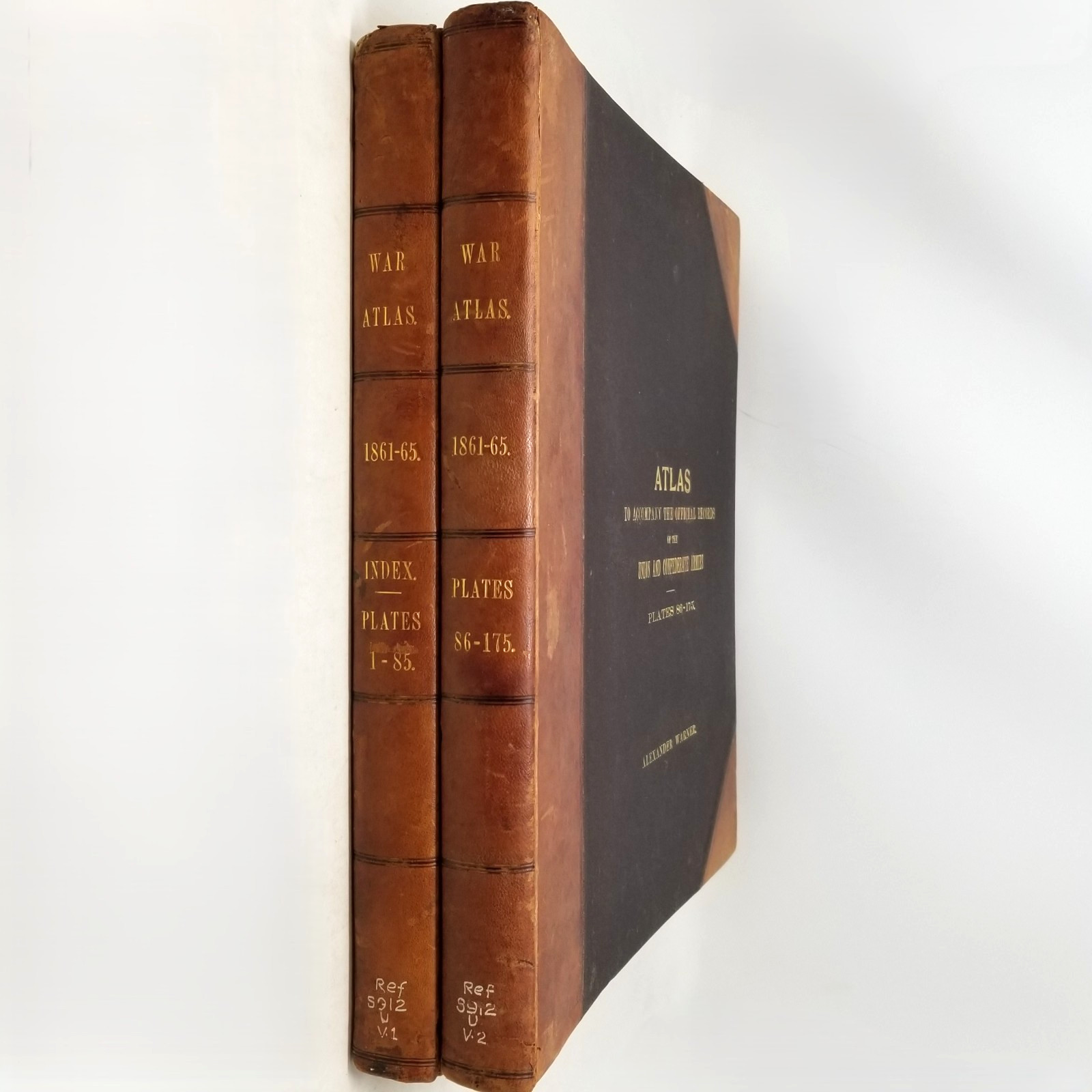
2-Volume Complete Atlas • 175 Maps & Plates • Leather & Cloth Binding
Atlas to Accompany the Official Records of the Union and Confederate Armies is the monumental visual companion to the United States Government’s official documentary record of the Civil War. Published in Washington by the Government Printing Office in 1895, this complete two-volume elephant folio set brings together the maps, battlefield plans, military diagrams, photographs, views, uniforms, insignia, and other visual records used to document Union and Confederate operations from 1861–1865.
Issued as the atlas component of The War of the Rebellion: A Compilation of the Official Records of the Union and Confederate Armies, the work was prepared under the direction of the U.S. War Department and published under Secretaries of War Redfield Proctor, Stephen B. Elkins, and Daniel S. Lamont. The Board of Publication included Major George B. Davis, Leslie J. Perry, and Joseph W. Kirkley, with Capt. Calvin D. Cowles responsible for the atlas compilation.
The two enormous volumes contain 175 numbered plates. Volume I includes the index and Plates 1–85; Volume II contains Plates 86–175. The material ranges from detailed campaign and battlefield maps to fortifications, troop positions, military installations, wartime and immediate postwar photographs, engineering drawings, and striking illustrated plates documenting uniforms, rank insignia, equipment, and military organization. Many maps retain printed color distinguishing Union and Confederate positions and movements.
Among the subjects represented are major campaigns and theaters of the war, including Gettysburg and numerous other engagements, along with maps showing military departments, geographic divisions, transportation routes, defensive works, and troop movements. Photographic plates preserve views such as the Confederate Capitol at Richmond and military hospitals and installations photographed during and immediately after the conflict. Together, the two volumes form an extraordinary primary-source visual record of the Civil War as assembled by the federal government from the official military archives.
Good condition. This substantial 1895 two-volume atlas set retains the honest signs of more than a century of preservation and institutional use. Both elephant folio volumes remain complete and solidly bound despite their considerable size and weight. The original leather-and-cloth bindings show rubbing, surface wear, soiling, and wear to the leather corners and edges. Leather spines remain present with gilt titling intact and show age-related rubbing, handling wear, and old reference markings near the feet. Volume 1 has a small spine tear at the foot.
The first several pages show some closed tears, creasing, and staining. The set is ex-library, with institutional markings including spine notation and stamps to the pastedowns. Pencil check marks appear beside map entries in the Table of Contents of Volume I. Beyond these library and reference markings, no significant additional annotation was noted.
Interior plates remain highly presentable overall. Maps, plans, photographs, illustrated military plates, and printed-color material retain strong visual clarity. Bindings remain sound with no major structural instability noted. Please review all photographs carefully, particularly the bindings, preliminary leaves, library markings, and representative maps and plates.
Title: Atlas to Accompany the Official Records of the Union and Confederate Armies
Compiler: Capt. Calvin D. Cowles
Publisher: Government Printing Office
Location Published: Washington
Year: 1895
Edition: First Edition
Binding: Hardcover; leather spines and corners over textured black cloth boards
Dust Jacket: No dust jackets
Volumes: Two volumes, complete
Plates: 175 numbered plates; Volume I, Plates 1–85; Volume II, Plates 86–175
Size: Elephant folio, approximately 15\" x 18\"
Subject: American Civil War, Military History, Historical Cartography
Topic: Union Army, Confederate Army, Battlefield Maps, Campaign Plans, Military Engineering, Civil War Photography, Uniforms & Insignia, Official Records
Provenance: From the Oddfellow’s Collection; former institutional/reference copy
Notable Details: Complete first-edition two-volume atlas companion to the Official Records of the Union and Confederate Armies; 175 numbered plates encompassing battlefield and campaign maps, military plans, fortifications, photographs, uniforms, insignia, and other official visual documentation of the Civil War; many maps include printed color distinguishing military positions and geographic divisions.
Civil War Atlas, Official Records Union Confederate Armies, War Of The Rebellion Atlas, Government Printing Office 1895, Civil War Maps, Union Army Maps, Confederate Army Maps, Gettysburg Maps, Battlefield Plans, Military Atlas, Antique Maps, Civil War Photography, Military Uniforms, Civil War Insignia, Elephant Folio, 2 Volume Civil War Atlas, Official Records Atlas
📦 All books are carefully wrapped and shipped with tracking. Combined shipping is available.
📸 Please review all photos carefully for condition and content details, and feel free to reach out with any questions.